

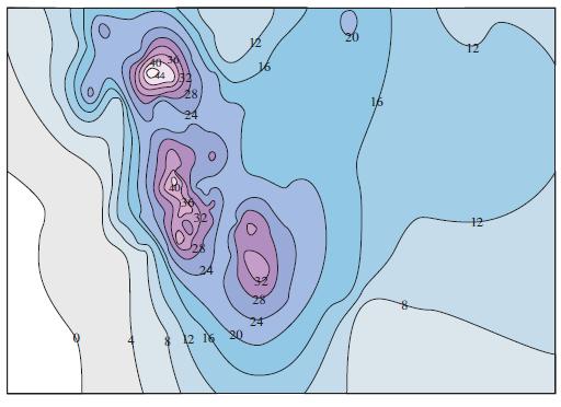
The contour map in Figure 12 shows the snowfall, in inches, that fell on the state of
Question:
The contour map in Figure 12 shows the snowfall, in inches, that fell on the state of Colorado on December 20 and 21, 2006. (The state is in the shape of a rectangle that measures 388 mi west to east and 276 mi south to north.) Use the contour map to estimate the average snowfall for the entire state of Colorado on those days.
Figure 12
Fantastic news! We've Found the answer you've been seeking!
Step by Step Answer:
Lets place the origin at the southwest corner of the sta...View the full answer

Answered By
Pushpinder Singh
Currently, I am PhD scholar with Indian Statistical problem, working in applied statistics and real life data problems. I have done several projects in Statistics especially Time Series data analysis, Regression Techniques.
I am Master in Statistics from Indian Institute of Technology, Kanpur.
I have been teaching students for various University entrance exams and passing grades in Graduation and Post-Graduation.I have expertise in solving problems in Statistics for more than 2 years now.I am a subject expert in Statistics with Assignmentpedia.com.
3+ Reviews
10+ Question Solved
Related Book For 

Question Posted:
