Before Gerardus Mercator designed his map of the world in 1569, sailors who traveled in a fixed
Question:
Before Gerardus Mercator designed his map of the world in 1569, sailors who traveled in a fixed compass direction could follow a straight line on a map only over short distances. Over long distances, such a course would be a curve on existing maps, which tried to make area on the map proportional to the actual area. Mercator’s map greatly simplified navigation: Even over long distances, straight lines on the map corresponded to fixed compass bearings. This was accomplished by distorting distances. On Mercator’s map, the distance of an object from the equator to a parallel at latitude u is given by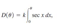
where k is a constant of proportionality. Calculus had not yet been discovered when Mercator designed his map; he approximated the distance between parallels of latitude by hand.
(a) Verify that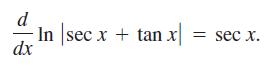
(b) Verify that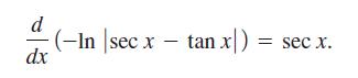
(c) Los Angeles has a latitude of 34°03′N. (The 03′ represents 3 minutes of latitude. Each minute of latitude is 1/60 of a degree.) If Los Angeles is to be 7 in. from the equator on a Mercator map, how far from the equator should we place New York City, which has a latitude of 40°45′N?
(d) Repeat part (d) for Miami, which has a latitude of 25°46′N.
Step by Step Answer:
a b c Since D3403 7 New York City should be placed ...View the full answer