

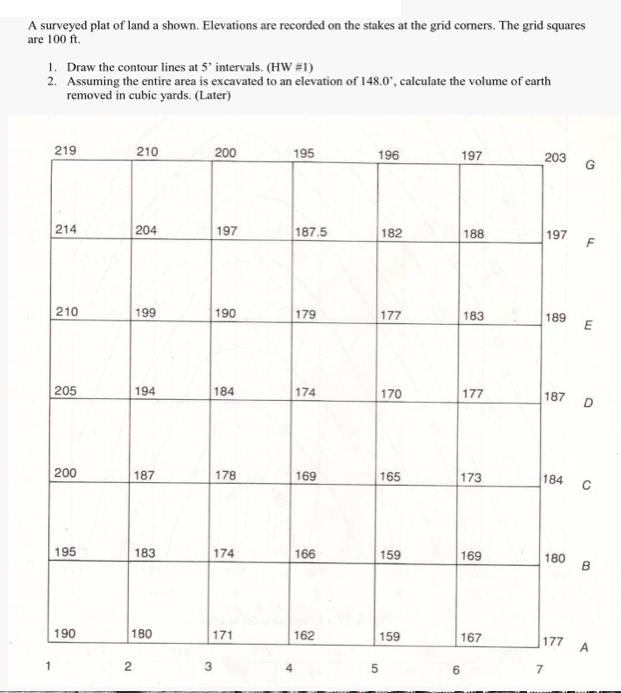
A surveyed plat of land a shown. Elevations are recorded on the stakes at the grid...
Fantastic news! We've Found the answer you've been seeking!
Question:
Transcribed Image Text:
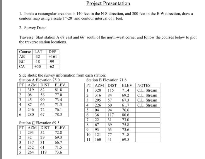
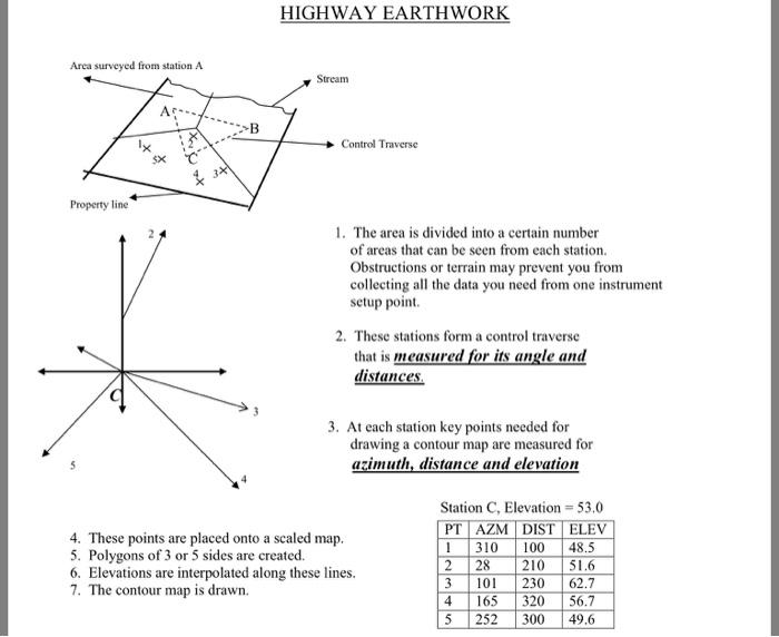
A surveyed plat of land a shown. Elevations are recorded on the stakes at the grid corners. The grid squares are 100 ft. 1. Draw the contour lines at 5' intervals. (HW #1) 2. Assuming the entire area is excavated to an elevation of 148.0", calculate the volume of earth removed in cubic yards. (Later) 219 214 210 205 200 195 190 210 2 204 199 194 187 183 180 200 197 190 3 184 178 174 171 195 187.5 179 174 169 166 162 196 182 5 177 170 165 159 159 197 6 188 183 177 173 169 167 203 197 189 187 180 7 E 184 с D B 177 A Project Presentation 1. Inside a rectangular area that is 140 feet in the N-S direction, and 300 feet in the E-W direction, draw a contour map using a scale 1"-20' and contour interval of 1 feet. 2. Survey Data: Traverse: Start station A 68'east and 66° south of the north-west corner and follow the courses below to plot the traverse station locations. Course LAT DEP -32 +161 -18 -99 +50 -62 AB BC CA Side shots: the survey information from each station: Station A Elevation 75.0 PT AZM DIST 1 319 82 08 56 23456 45 90 2345 87 66 72 246 280 67 ELEV. 81.8 77.0 73.4 71.3 Station C Elevation 69.5 PT AZM DIST ELEV. 1 293 32 137 252 264 52 29 31 61 76.1 78.3 72.8 69.3 66.7 71.5 119 73.6 Station B Elevation 71.8 PT AZM DIST 1 328 115 2 316 84 3 295 57 226 60 04 94 36 117 22 31 4 5 6 7 8 9 67 69 93 63 77 41 10 121 11 160 ELEV. 71.4 69.2 67.3 61.7 76.6 80.6 73.0 75.8 73.6 71.8 69.5 NOTES C.L. Stream C.L. Stream C.L. Stream C.L. Stream Arca surveyed from station A Property line 341 HIGHWAY EARTHWORK Stream Control Traverse 1. The area is divided into a certain number of areas that can be seen from each station. Obstructions or terrain may prevent you from collecting all the data you need from one instrument setup point. 2. These stations form a control traverse that is measured for its angle and distances. 3. At each station key points needed for drawing a contour map are measured for azimuth, distance and elevation 4. These points are placed onto a scaled map. 5. Polygons of 3 or 5 sides are created. 6. Elevations are interpolated along these lines. 7. The contour map is drawn. Station C, Elevation = 53.0 PT AZM DIST ELEV 1 310 100 2 28 210 3 101 230 165 320 252 300 45 48.5 51.6 62.7 56.7 49.6 A surveyed plat of land a shown. Elevations are recorded on the stakes at the grid corners. The grid squares are 100 ft. 1. Draw the contour lines at 5' intervals. (HW #1) 2. Assuming the entire area is excavated to an elevation of 148.0", calculate the volume of earth removed in cubic yards. (Later) 219 214 210 205 200 195 190 210 2 204 199 194 187 183 180 200 197 190 3 184 178 174 171 195 187.5 179 174 169 166 162 196 182 5 177 170 165 159 159 197 6 188 183 177 173 169 167 203 197 189 187 180 7 E 184 с D B 177 A Project Presentation 1. Inside a rectangular area that is 140 feet in the N-S direction, and 300 feet in the E-W direction, draw a contour map using a scale 1"-20' and contour interval of 1 feet. 2. Survey Data: Traverse: Start station A 68'east and 66° south of the north-west corner and follow the courses below to plot the traverse station locations. Course LAT DEP -32 +161 -18 -99 +50 -62 AB BC CA Side shots: the survey information from each station: Station A Elevation 75.0 PT AZM DIST 1 319 82 08 56 23456 45 90 2345 87 66 72 246 280 67 ELEV. 81.8 77.0 73.4 71.3 Station C Elevation 69.5 PT AZM DIST ELEV. 1 293 32 137 252 264 52 29 31 61 76.1 78.3 72.8 69.3 66.7 71.5 119 73.6 Station B Elevation 71.8 PT AZM DIST 1 328 115 2 316 84 3 295 57 226 60 04 94 36 117 22 31 4 5 6 7 8 9 67 69 93 63 77 41 10 121 11 160 ELEV. 71.4 69.2 67.3 61.7 76.6 80.6 73.0 75.8 73.6 71.8 69.5 NOTES C.L. Stream C.L. Stream C.L. Stream C.L. Stream Arca surveyed from station A Property line 341 HIGHWAY EARTHWORK Stream Control Traverse 1. The area is divided into a certain number of areas that can be seen from each station. Obstructions or terrain may prevent you from collecting all the data you need from one instrument setup point. 2. These stations form a control traverse that is measured for its angle and distances. 3. At each station key points needed for drawing a contour map are measured for azimuth, distance and elevation 4. These points are placed onto a scaled map. 5. Polygons of 3 or 5 sides are created. 6. Elevations are interpolated along these lines. 7. The contour map is drawn. Station C, Elevation = 53.0 PT AZM DIST ELEV 1 310 100 2 28 210 3 101 230 165 320 252 300 45 48.5 51.6 62.7 56.7 49.6
Expert Answer:

Related Book For 

Systems Analysis And Design
ISBN: 9781118897843
6th Edition
Authors: Alan Dennis, Barbara Haley Wixom, Roberta M. Roth
Posted Date:
Students also viewed these accounting questions
-
J. Fairweather is the managing director of a security company in Jamaica. As part of his management duties, he monitors the news to assess the impact of environmental changes on his operations. His...
-
A cantilever beam is subjected to load P at mid-span and counterclockwise moment M at B (see figure). (a) Find an expression for moment M in terms of the load P so that the reaction moment MA at A is...
-
Goddard Company has used the FIFO method of inventory valuation since it began operations in 2015. Goddard decided to change to the average cost method for determining inventory costs at the...
-
Spade and Thress are forming a partnership, Vintage Leather Goods, to import merchandise from Ireland. Spade is especially artistic and will travel to Ireland to buy the merchandise. Thress is a...
-
Compute the pseudo inverse of A. A = -1
-
On December 14, 2011, appellant Aaron Olson contracted to receive telephone service from respondent CenturyLink and also applied for reduced-rate service that CenturyLink provides through Minnesotas...
-
After the success of the companys first two months, Santana Rey continues to operate Business Solutions. The November 30, 2011, unadjusted trial balance of Business Solutions (reflecting its...
-
A world without ERP software would be mostly inefficient because a lot of financial processes would be inefficient. ERP software helps make a lot of financial processes like expense tracking, ledger...
-
Table, from a General Social Survey, relates responses on R = religious service attendance (1 = at most a few times a year, 2 = at least several times a year), P = political views (1 = liberal, 2 =...
-
Rearrange the following lines of code to read two integers until two different input values are entered. How to use this tool Unused valid = True second = int (input()) while not valid : valid print...
-
What are the main differences between the user-kernel threads models? Which one of these models is likely to trash the system if used without any constraints?
-
Each school-week night John can play video games, talk on the phone, or watch a movie. He has a total of five hours to spend on one of these three things. Using the information, fill out the marginal...
-
What is a project manager? What skills, knowledge, and abilities are required for a project manager? What leads to a project manager's success? What is more important to a project's success; project...
-
Write 400 - 600 words that respond to the following questions with your thoughts, ideas, and comments. This will be the foundation for future discussions by your classmates. Be substantive and clear,...
-
A well, which consists of a 15.25 cm diameter cylindrical pipe placed in the ground, has 31.15 m of water in it. How many gallons of water are in the well?
-
Please help with these, thank you!! Vector a has components ax= -4.00 m/s and ay= +4.60 m/s. What is the magnitude of the vector a ? m/s
-
Interview managers at three companies in your area about their use of ERP. How have their experiences been similar? What accounts for the similarities and differences?
-
John is a systems analyst on the Holiday Travel Vehicle project team (see minicase 4, this chapter). The team is currently developing the systems user interface design. John has been given the task...
-
Frank, the IS department manager at the Kelso Company was brought in to the firm with a mandate to get the IS department shaped up. Kelso management was dissatisfied with a number of aspects of the...
-
In the new system for Jones Legal Investigation Services, a client-attorney provides information about a case and requests that a case-investigation be conducted. The cases that this firm specializes...
-
Santinis new contract for 2019 indicates the following compensation and benefits: Santini is 54 years old at the end of 2019. He is single and has no dependents. Assume that the employer matches $1...
-
In 2019, Nina contributes 10 percent of her $100,000 annual salary to her 401(k) account. She expects to earn a 7 percent before-tax rate of return. Assuming she leaves this (and any employer...
-
In 2019, Nitai (age 40) contributes 10 percent of his $100,000 annual salary to a Roth 401(k) account sponsored by his employer, AY Inc. AY Inc. matches employee contributions to the employees...

Study smarter with the SolutionInn App