

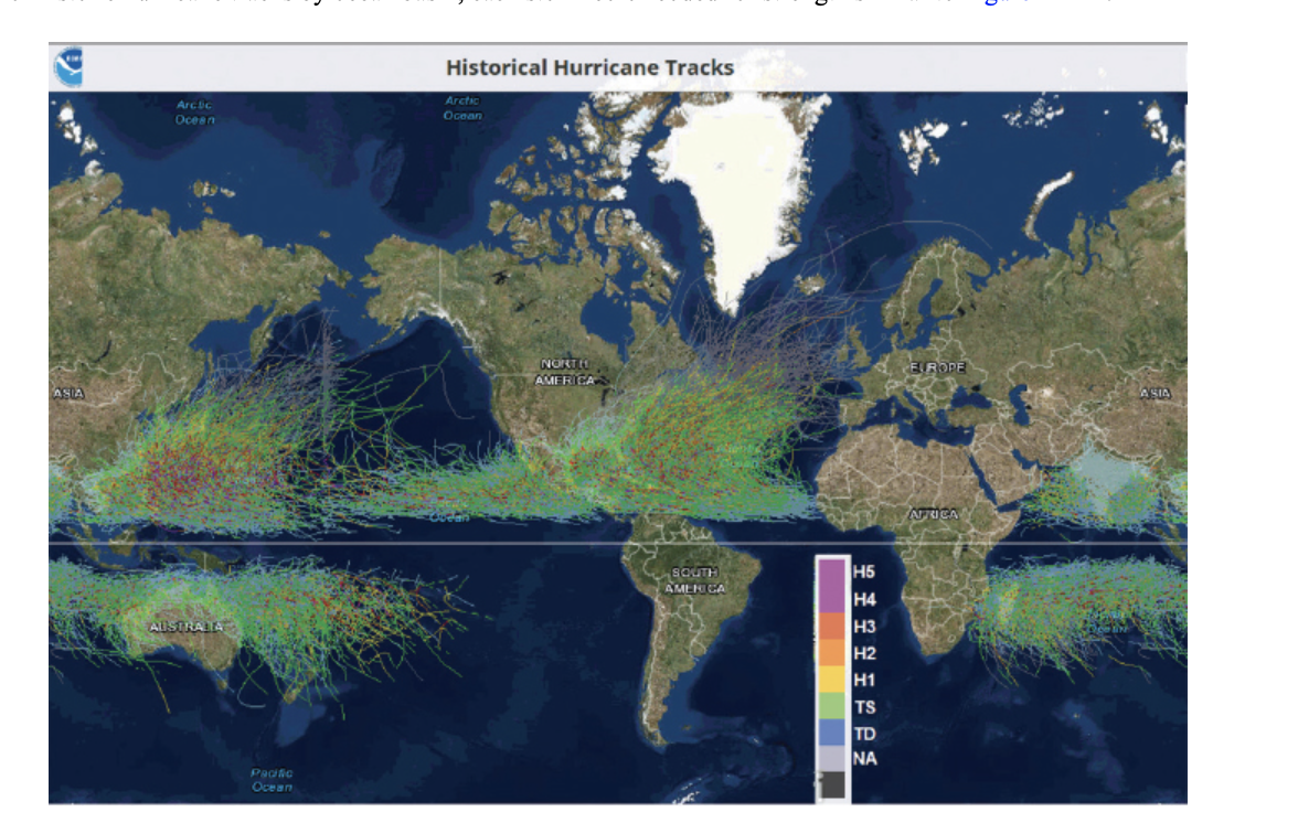
ASIA Arclic Ocean AUSTRALIA Pacific Ocean Historical Hurricane Tracks Arctic Ocean NORTEL AMERICA SOUTH AMENICA ....
Fantastic news! We've Found the answer you've been seeking!
Question:
Transcribed Image Text:
ASIA Arclic Ocean AUSTRALIA Pacific Ocean Historical Hurricane Tracks Arctic Ocean NORTEL AMERICA SOUTH AMENICA ▬▬▬▬▬▬▬▬. H5 H4 H3 H2 H1 TS TD ΝΑ EUROPE AFRICA ASIA 7. According to Figure 12A-2, tropical storms formed in either the Northern or Southern Hemispheres in Figure 12A-2.) a. do b. do not 8. This absence of tropical cyclone activity at the equator a. is b. is not a. western North Pacific b. eastern South Pacific c. South Atlantic cross the equator from one hemisphere to the other. (The equator is the white horizontal line due to the absence of the Coriolis Effect, which is essential in producing circulation during storm formation. 9. According to Figure 12A-2, tropical cyclones track through many ocean basins, and especially the Ocean. In 2018, Typhoon Jebi was the costliest typhoon to strike Japan in 25 years, causing multiple fatalities and billions of dollars in damage. In 2020, they were threatened by Typhoon Haishen, which was the third deadly typhoon in a 2-week period. The frequency of storms in this location is correlated with the large expanse of year-round warm waters. ho path on the map. 10. Click on data and view the category status of the hurricane throughout its path. You can also scroll along on the map to see the changing category, wind speeds, and pressure. The highest category rank Isaias became was a with maximum sustained winds at 75 kts (86 mph). a. H1 or category 1 b. H2 or category 2 c. H3 or category 3 For information on Atlantic and Eastern Pacific cyclones, go to the National Hurricane Center's webpage (Link 12A-4). On the menu under Archives, track maps and individual storm reports for past years can be found. Another valuable item under Educational Resources is a list of "Frequent Questions." Tropical cyclones in the mid-Pacific can be followed from the Central Pacific Hurricane Center (Link 12A-5) and those of the western Pacific at the Joint Typhoon Warning Center (Link 12A-6). Storm Surge A storm surge is a dome of ocean water topped by high waves and driven on shore by storm winds. The greatest potential for coastal flooding and beach erosion occurs along a shallow sloping shoreline when a storm surge coincides with high tide. Go to the National Hurricane Center's (NHC) main page (Link 12A-4) and scroll over Educational Resources on the top menu to open a list of life-saving information. Click on "Storm Surge" for animations of storm surge, often the most deadly aspect of hurricanes, and photographs of the damage they cause. 11. The Surge Vulnerability Facts at the bottom of the same Storm Surge Overview page states a strong hurricane with a 23-ft. storm surge coming ashore along the Gulf Coast could flood 57% of arterial roads, almost half of rail miles, 29 airports, and virtually all ports in the area. It would also risk the inundation of of interstate highways. Such input is crucial for emergency planners to order evacuations and prepare for possible destruction. In 2005 Hurricane Katrina produced a 24- to 28-ft. storm surge over a 20-mi. stretch of the Mississippi coast. a. 27% b. 49% c. 67% A weakening cyclone does not guarantee a smaller storm surge, and all precautions must be taken within the predicted landing area. p. 208 ASIA Arclic Ocean AUSTRALIA Pacific Ocean Historical Hurricane Tracks Arctic Ocean NORTEL AMERICA SOUTH AMENICA ▬▬▬▬▬▬▬▬. H5 H4 H3 H2 H1 TS TD ΝΑ EUROPE AFRICA ASIA 7. According to Figure 12A-2, tropical storms formed in either the Northern or Southern Hemispheres in Figure 12A-2.) a. do b. do not 8. This absence of tropical cyclone activity at the equator a. is b. is not a. western North Pacific b. eastern South Pacific c. South Atlantic cross the equator from one hemisphere to the other. (The equator is the white horizontal line due to the absence of the Coriolis Effect, which is essential in producing circulation during storm formation. 9. According to Figure 12A-2, tropical cyclones track through many ocean basins, and especially the Ocean. In 2018, Typhoon Jebi was the costliest typhoon to strike Japan in 25 years, causing multiple fatalities and billions of dollars in damage. In 2020, they were threatened by Typhoon Haishen, which was the third deadly typhoon in a 2-week period. The frequency of storms in this location is correlated with the large expanse of year-round warm waters. ho path on the map. 10. Click on data and view the category status of the hurricane throughout its path. You can also scroll along on the map to see the changing category, wind speeds, and pressure. The highest category rank Isaias became was a with maximum sustained winds at 75 kts (86 mph). a. H1 or category 1 b. H2 or category 2 c. H3 or category 3 For information on Atlantic and Eastern Pacific cyclones, go to the National Hurricane Center's webpage (Link 12A-4). On the menu under Archives, track maps and individual storm reports for past years can be found. Another valuable item under Educational Resources is a list of "Frequent Questions." Tropical cyclones in the mid-Pacific can be followed from the Central Pacific Hurricane Center (Link 12A-5) and those of the western Pacific at the Joint Typhoon Warning Center (Link 12A-6). Storm Surge A storm surge is a dome of ocean water topped by high waves and driven on shore by storm winds. The greatest potential for coastal flooding and beach erosion occurs along a shallow sloping shoreline when a storm surge coincides with high tide. Go to the National Hurricane Center's (NHC) main page (Link 12A-4) and scroll over Educational Resources on the top menu to open a list of life-saving information. Click on "Storm Surge" for animations of storm surge, often the most deadly aspect of hurricanes, and photographs of the damage they cause. 11. The Surge Vulnerability Facts at the bottom of the same Storm Surge Overview page states a strong hurricane with a 23-ft. storm surge coming ashore along the Gulf Coast could flood 57% of arterial roads, almost half of rail miles, 29 airports, and virtually all ports in the area. It would also risk the inundation of of interstate highways. Such input is crucial for emergency planners to order evacuations and prepare for possible destruction. In 2005 Hurricane Katrina produced a 24- to 28-ft. storm surge over a 20-mi. stretch of the Mississippi coast. a. 27% b. 49% c. 67% A weakening cyclone does not guarantee a smaller storm surge, and all precautions must be taken within the predicted landing area. p. 208
Expert Answer:
Answer rating: 100% (QA)
Ans 7 Do not Tropical storm form in one hemisphere do not cross the equator ... View the full answer

Related Book For 

Posted Date:
Students also viewed these law questions
-
Southern Atlantic Distributors began operations in January 2018 and purchased a delivery truck for $40,000. Southern Atlantic plans to use straight-line depreciation over a four-year expected useful...
-
Ocean Traders of North America is a firm based in Mobile, Alabama, that specializes in seafood exports and commonly uses letters of credit (L/Cs) to ensure payment. It recently experienced a problem,...
-
Northern Track is developing a special vehicle for Arctic exploration. The development requires investments of $60 000, $50 000, and $40 000 for the next 3 years, respectively. Net returns beginning...
-
Which of the following statements represent(s) how expenses affect equity? If expenses increase, then total equity decreases. If expenses decrease, then equity will decrease. Higher expenses result...
-
Why is it important for managers to try to reduce manifest conflict and create a good conflict aftermath?
-
Ralston Sports Corporation completed the following selected transactions during 2014: Jan 6 Declared a cash dividend on the 10,000 $2.25 preferred shares outstanding. Declared a $0.20 per share...
-
Pop and Mom Ltd bought 120,000 of the 200,000 issued ordinary 1 shares of Sonny Ltd for 300,000 on 31 July 2004. Sonny Ltd financial statements are drawn up annually to 31 December. The balance sheet...
-
You have just been hired by SecuriDoor Corporation, the manufacturer of a revolutionary new garage door opening device. The president has asked that you review the companys costing system and do what...
-
Paisios Ltd paid a $4.00 dividend per share recently. Paisiosnormally pays dividends once a year. Analyst estimates that Paisioswill increase its dividends 10% per year indefinitely. The currentmar 2...
-
Craig Fisher started a lawn service called Craigs Quick Cut to earn money over the summer months. Fisher has decided to use the following accounts for recording transactions: Assets Revenue Cash Lawn...
-
Consider search keys that are distinct integers. If the hash function is h(key) = key modulo 5 and separate chaining resolves collisions, where in the hash table do the following search keys appear...
-
Discuss the relative impact of international business on your daily lives.
-
Try to identify the brands of each product that are made by domestic firms. Follow up by meeting with a small group of your classmates and completing these activities,
-
Using the example from Exercise 6.3: a) What two values of X (the count) would encompass the middle 50% of the results? b) 75% of the counts would be less than ______. c) 95% of the counts would be...
-
Give an example of a continuous variable that we routinely treat as if it were discrete.
-
Much before the dairy cooperative movement took roots in the country, the trail to milk revolution was set ablaze by Babasaheb Chitale .The journey began in 1939, in the small town of Bhilwadi which...
-
W1 Discussion Question 2: How Do We Explain Health Recovery? Purpose: discussion post, you are asked to reflect and report on your own experience with illness and recovery of health. By investigating...
-
The manager for retail customers, Katie White, wants to hear your opinion regarding one business offer she has received from an entrepreneur who is starting a mobile phone app called Easy Money. The...
-
Find the area of each geometric figure. If the figure is a circle, give an exact area and then use the given approximation for p to approximate the area. 1. 2. 3. Use 3.14 for Ï. -25 cm- 12 cm...
-
For each food described, find the percent of total calories from fat. If necessary, round to the nearest tenth percent. Nutrition Facts Serving Size cup (33g) Servings Per Container About 9 Amount...
-
Find two other ways of naming each angle. 1. y 2. ABE (just name one other way) 15 50 45
-
Describe the factors that affect personal financial decisions.
-
List eight strategies for achieving financial goals.
-
Explain opportunity costs and how they might affect your personal financial decisions.

Study smarter with the SolutionInn App