

Continental glaciation advanced and retreated over North America and Europe producing many erosional and depositional features (e.g.,
Question:
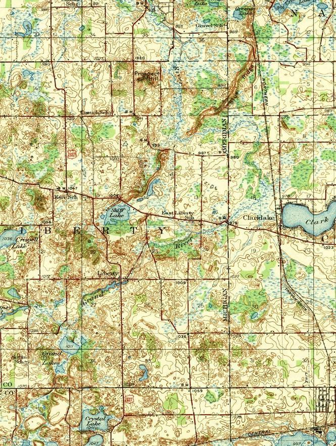
Continental glaciation advanced and retreated over North America and Europe producing many erosional and depositional features (e.g., till plain, drumlin and esker). Many relatively flat plains of unsorted coarse till are formed behind terminal moraines. These till plains generally have low, rolling relief, deranged drainage patterns, and depositional features. Drumlins, smooth hills made of till shaped by the ice, are oriented in the direction of the movement. Eskers are curving, narrow deposits of sand and coarse gravel left by meltwater stream deposits in tunnels beneath the ice. Kettles are depressions left by melting blocks of ice that were buried in the drift and are found in both ground moraines and in outwash plains.
1. Eskers are frequently excavated for construction because they are made up of highly porous sand and gravel. Locate and identify by name a prominent esker the up portion of the map on Page 15.
_________________________.
How long is this esker in km? ______________. You will measure its length in Google Earth Pro.
With the kmz layers checked, you will measure the esker’s length using the ruler tool. Click on the Show ruler icon. Make sure the Path tab is activated. Change the measurement unit to Kilometers. Click on one end of the esker to start the line. Keep clicking to follow the course of the esker until reaching another end of the esker. Its length is shown beside the unit.
Uncheck the kmz layer, zoom in further to see more details in the image. You may be able to see 3-D terrain if you checked Terrain data. Do you see the esker clearly in the image? Describe what you saw from Google Earth. Had there been any changes between 1935 and the imaging date (please identify it from Google Earth)? If so, what might have caused the changes?
2.. Sometimes an isolated block of ice, perhaps more than a kilometer across, persists in a till plain, an outwash plain, or valley floor after a glacier retreats. It may take 20 to 30 years for the ice to melt. When the block finally melts, it leaves behind a kettle lake with a steep-sided hole frequently filled with water. Locate several named kettles that are ponds or lakes on this map and identify their general location.
Expert Answer:
Given Data Esker also spelled estare ore eschare a long navcrow winding rudge composed of ... View the full answer

