

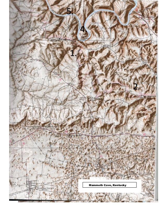
7. 1. Mammoth Cave Quadrangle, Kentucky 2. 3. 4. 5. southern half. Thus, the southem half...
Fantastic news! We've Found the answer you've been seeking!
Question:
Transcribed Image Text:
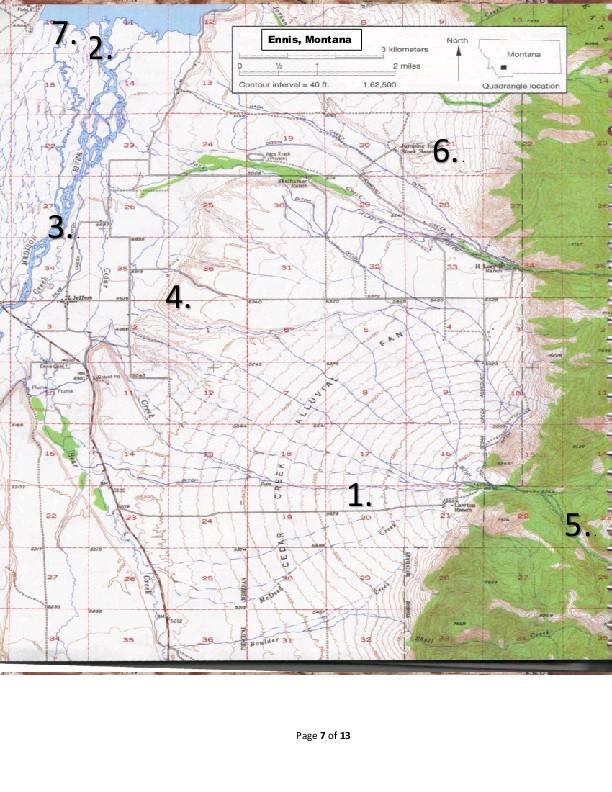
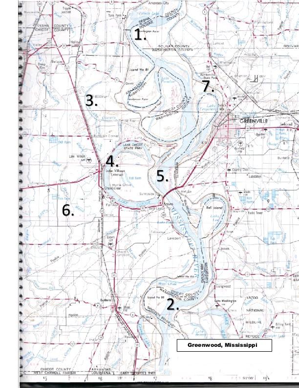
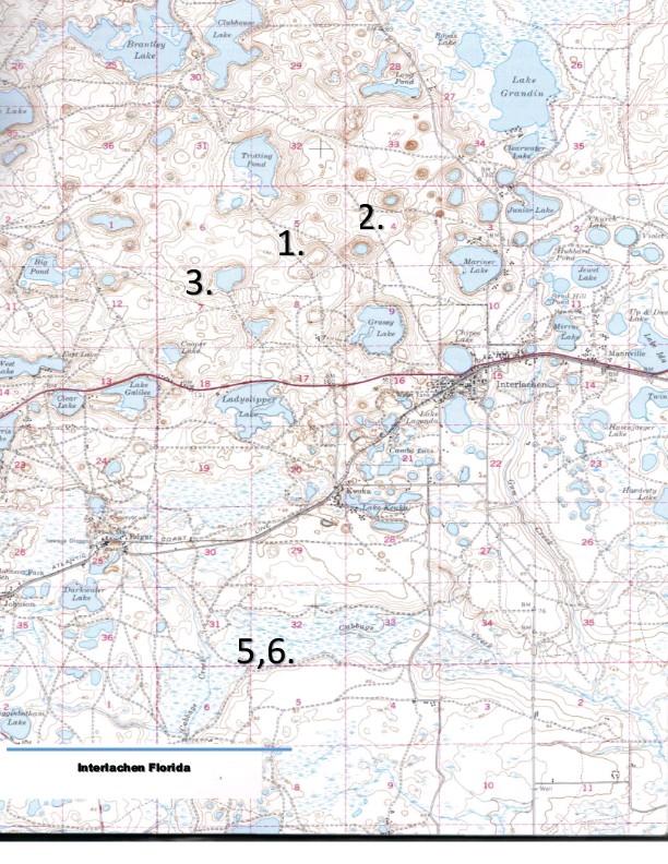
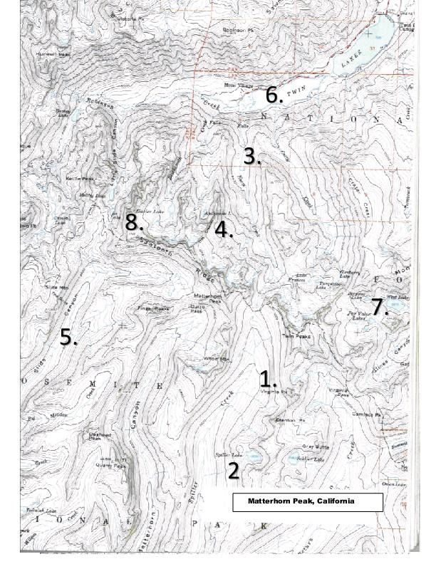
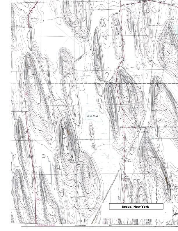
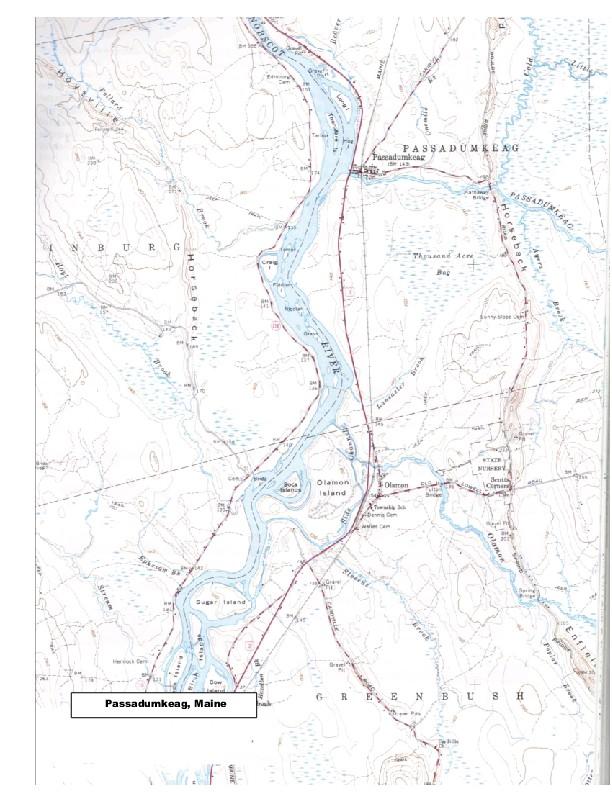
7. 1. Mammoth Cave Quadrangle, Kentucky 2. 3. 4. 5. southern half. Thus, the southem half will come to resemble the northern half; (d) with uplift, stream will flow faster, incising deep ravines. Thus, both halves will look entirely different than they do now. 6. 7. Estimate the level of the water table in several sinkhole lakes around the map, as well as the level of the swampy ground in the south. From this, can you tell what the hydraulic gradient of the underground water is? That is, can you determine a direction of flow? (a) north; (b) west; (c) southeast; (d) east; (e) south; (f) northeast; (g) northwest. Why does the stream flowing into Double Sink (near Turnhole Ferry) end so abruptly there? (a) it is in intermittent stream that loses its water downstream due to evaporation; (b) the land tums uphill, preventing the water from climbing upward; (c) the area is underlain by extremely porous sandstone; (d) they flow into a sinkhole that connects to an underground stream; (e) the water volume is insufficient to sustain flow. Examine the topography in the east-central part of the map. A number of valleys such as Cedar Spring Valley, Woolsey Hollow, and Owens Valley resemble stream cut valleys, but there are no streams flowing in them. What might cause this? (a) the area is arid, and the valleys are occupied by intermittent streams that only flow during flash floods; (b) the sanstone bedrock absorbs the water faster than it can accumulate is the streams; (c) the stram gradients are so steep that the water flows into the main river faster than it can accumulate in the stream valleys; (d) the are solution valleys that connect to underground caves with underground rivers. Where is the water table in this area, compared to the water table in the Interlachen, Florida, area? (a) they are similar; (b) it is deeper, (c) it is shallower; (d) it varies in both areas. What is Tumhole Bend on Green River? (a) water gap; (b) incised meander; (c) grand canyon; (d) stream terrace; (e) braided stream. Examine the river (Green River) in the northern part of the map. In the stream erosion cycle, is this area in (a) youth; (b) maturity, or (c) old age? Is the Mammoth Cave area in the stage of (a) youth; (b) maturity, or (c) old age, of the karst erosion cycle? Re-examine the previous map. Is the interlachen area in the stage of (a) youth, (b) maturity, or (c) old age, of the karst erosion cycle. Matterhorn Peak Quadrangle, California What glacial topographic name is applied to each of the following features? (Consult the following list) (a) glacial staircase; (b) end moraine; (c) lateral moraine; (d) pater noster lakes; (e) arête; (f) hanging valley; (g) hom; (h) U-shaped glacial valley; (i) roche moutinee; (j) cirque; (k) cirque lake; (1) medial moraine; (m) esker; (n) drumlin. 1. Virginia Peak (SE part of map). 2. Spiller Lake (SE part of map). 3. Horse Creek up-valley from the waterfalls at about 7,600" (NE part of map) 4. The Cleaver (center of map). 5. Slide Canyon (SW part of map) 6. Twin Lakes (NE part of map). 7. The land under Par Value Lakes (E central part of map). 8. The cliffs surrounding Glacier Lake (W central part of map). Page 4 of 13 Ennis Quadrangle, Montana On the map provided, identify the following stream-formed topographic landforms: Greenwood Quadrangle, Mississippi - Arkansas On the map provided, identify the following floodplain topographic landforms: (a) meander (b) meander scar; (c) oxbow lake; (d) point bar; (e) levee; (1) cutoff; (g) yazoo tributary (h) distributary: (1) alluvial fan; () braided stream; (k) stream terrace. Interlachen Quadrangle, Florida 1. 2. 3. 4. 1. This landform is a/an: (a) alluvial fan; (b) delta; (c) bajada; (d) pediment; (e) bolson. 2. This landform is a/an: (a) alluvial fan; (b) delta; (c) bajada; (d) rill; (e) canyon 3. This landform is a/an: (a) delta; (b) braided stream; (c) baja da; (e) canyoh. 4. This landform is a/an: (a) canyon; (b) stream terrace; (c) bajada; (d) alluvial fan; (e) distributary. 5. This landform is a/an: (a) distributary; (b) canyon; (c) stream terrace; (d) delta; (e) meander. 6. This landform is a/an: (a) distributary; (b) canyon; (c) stream terrace; (d) delta (e) bajada. 7. . This landform is a/an: (a) distributary; (b) canyon; (c) stream terrace; (d) delta (e) bajada. 5. 6. 7.. A pair of sink-holes straddles the boundary between Sections 5 and 8 about 1.5 miles north of the east- west highway (at Number 1) that crosses the central part of the map area. What is the approximate elevation (in feet above sea level) of the bottoms of these two sinks? (a) 55; (b) 130; (c) 300; (d) 100; (e) 90 In the same general area, an unnamed lake occupies a sink-hole in the NE % of Sec. 7, and another occurs in the SW % of Sec. 4. Assuming the water surface of these two lakes lies 5 feet below the elevation of the contour nearest the lake shores, what is the elevation of these two lakes? Sec. 4 lake? (a) 90'; (b) 85'; (c) 80' (d) 75' (e) 70'; (f) 65'; (g) 60' Sec. 7 lake? (a) 90'; (b) 85'; (c) 80' (d) 75' (e) 70'; (f) 65'; (g) 60' Why are the two sinks in Sections 5 and 8 (Number 1) dry (that is, they contain no lakes) when Section 7 lake and Section 4 lake both lie less than a mile away? (a) they are underlain by a porous sand that can hold no water; (b) they have been drained for use as a landfill; (c) the bottom is filled with sediment to a level above the water table; (d) an impermeable clay "plug" underground retards the flow of water into the sinkhole. The blue "grass" symbol in the south (lower) part of the map indicates swampy conditions. What accounts for the preponderance of near-surface water there? (a) the water table is near the surface; (b) the area is underlain by impermeable shale; (c) it is a coastal swamp covered by sea water at high tide; (d) the land is so fat the surface drainage is retarded; (e) the area is infested with beavers that have constructed many beaver dams. Generally speaking, the northern half of the area has greater relief than the southern half of the map area. The northern half has no streams, whereas the southern half has Gun Creek Cabbage Creek, and Little Cabbage Creek. Assuming that these two areas reflect different stages in the evolution of karst topography, will the northern half become or like the southem half during the passage of time, or vice-versa? (a) because of global warming, the rise in sea level will cause the water table to rise also. Thus, the northern half will come to resemble the southern half; (b) there will be no relative change. Conditions in both halves will remain much the same; (c) s the land rises by isostasy. The water table will drop, creating deep sinkholes in the Page 3 of 13 Sodus Quadrangle, New York 2. 3. 4. 5. 6. 7. 1. 2- What geologic name is applied to these glacial features, such as Brantling Hill? (a) esker; (b) roches moutinee (c) arête; (d) drumlin; (e) kame terrace; (f) kettle; (g) varve. What type of material are they probably composed of? (a) glacial outwash; (b) glacial till (c) ice-contact stratified drift; (d) glacial lake deposits; (e) turbidites; (f) evaporate deposits. 3. These landforms are produced by: (a) meltwater streams flowing beneath the surface near the terminus of a wasting glacier, (b) by ice flowing over a bedrock surface, producing a rounded, shiny knob that is heavily striated; (c) by two adjacent glaciers deepening and widening a glacial valley to produce a knife-like ridge; (d) by a re-advancing glacier that plows over till deposits left behind from a previous retreat phase; (e) as crevasse fill of sand and gravel in a wasting glacier; (f) from ice blocks that settle into wasting glacial deposits; (g) in glacial lake deposits. Passadumkeag Quadrangle, Maine The main use of these features is: (a) as an important sand and gravel source; (b) as a glacial streamline feature that indicates the direction of glacial flow; (c) as an indication of the glacial budget; (d) to show the position of the snow (fim) line. The direction of glacial movement was: (a) north; (b) south; (c) east; (d) west; (e) northwest; (f)southwest (g) southeast; (h) northeast.; Draw an arrow on the map showing the likely direction of glacial movement. topographic features? What man-made features are affected by these What geologic name is applied to the glacial ridges shown here?? (a) esker; (b) roches moutinee (c) arête; (d) drumlin; (e) kame terrace; (f) kettle; (g) varve. What type of material are they probably composed of? (a) glacial outwash; (b) glacial till (c) ice-contact stratified drift; (d) glacial lake deposits; (e) turbidites; (f) evaporate deposits. These landforms are produced by: (a) meltwater streams flowing beneath the surface near the terminus of a wasting glacier, (b) by ice flowing over a bedrock surface, producing a rounded, shiny knob that is heavily striated; (c) by two adjacent glaciers deepening and widening a glacial valley to produce a knife-like ridge; (d) by a re-advancing glacier that plows over till deposits left behind from a previous retreat phase; (e) as crevasse fill of sand and gravel in a wasting glacier; (f) from ice blocks that settle into wasting glacial deposits; (g) in glacial lake deposits. What man-made features are affected by these topographic features? Page 5 of 13 7.2. 3. m 35 Cret 4. AWAY 25 Contour interval 40 ft. ware Ennis, Montana Coppan chan CREEK CEDAR N Rebel Boulder 31 TREANDON 1. Page 7 of 13 3 komuters 2 miles 1.62,500 AN Cheek Ener North 6. Ca Seeth 10m **** Montana Quadrangle location Check 5. E maaja Walle Bose Tripple Jution DESHA COUNTY CHICSY COUNT d Poda po tam Halle 6. rocke CHICOT COUNTY WEST CARROLL FARISH $5 3. BOKW *** Tark Form Cornar My Chance 4. Luke Village Lakenall rom ARKANSAS LOUISIANA 16 h ABRALISED MISSIPP la Estimile Zake DESHA BOLIVAR 1 and Nor Luna LAKE CHICOT STATE PARK Chiegt v Janctions Arenses Cit fish Tam BOLINA COUNTY WASHINGTON COLINYS Lyon Ned CHLOR COUNTY COUNTY Sye SARICO COTINY) WASHINGTON 5. BAN EAST TROLT THAT 15 7 Later for friged to 50 Laseport Mos Chile NODO NOCNE BOUNDARY WASHINGTON COUNTY CHICOT COUN 2. Wirtomild Stan Park 7. Lamcet Taku VER ARKANSAS MISSISSIPP Fall island tich Wirally 48 mes Longwood Lake Washing Atise SEP Priscate Country Club Narod twin GREENVILLE Aside 709 [HO H' Footer 1314 Beber 117 Fade Taver YAZOO NATIONAL WILDLIFE Greenwood, Mississippi REFUCE 91:00 BOLIVAR weng bioreale Deload 6m RT Healt Durati Eiling far Fre TER STA Fot Hig Pund Fire Ave Lave Clear Jake ATENTIC 13. Figh Darker Lake Brantley Lake Lake Galle 3. H Blyer A Interlachen Florida Clubeng Lake Trulling Fund indyslipper 1. az 5,6. 2. Gramy Labe Boka Bent Pand Cabbage 16 Conhe 28 de Nach Bhole Lake Marine Lake Chiper Lai 110 Lake Grandin Clearwater Lake Junior Lake E 25 Interlachen Bred Hill ON 11 Jound Lake afirm Laky 14 The De Lake Manreville Howser Zale Handaty Liike Hob Smails Grog edss20 fonds S Pode Th Mammoth Cave, Kentucky wo Hurwaa Fi KettleP Ope tam 5. 200 Midday ROGEREN thony D Creek Dexhead Peak Erotier Late 8. Strients Canyon Pasterbarn Ettura PALE Mallarhom Peak Spiller Reginson P Greek Mo 4. "HE Creek Laze Falle (Spelfer Lade 3. Kard 20 6. 1. Virginia TWIN Etanton vaks Fake Terp ** Grey Watte Rekler take MANIPL LAKES Last C I crape th love fam H Cresi Matterhorn Peak, California Joy Your Laker 7. Camlacs Pk Stines pra k great Wiskey 5 Mon Canyo Onteiner D FAIRVILLE 0.0 M Calafan Braatios Mill PANY LIS School $32 NEWARK Mad Prad 23 Sodus, New York SOUTH Inne HOVEVE Folland B UT R G Bar Bos Horsebac Sugar faland VE VIDE Dow Passadumkeag, Maine LOOSION Boca talanes Olamon Island gross G R Pareadamkeag 15 143 PASSADUMEENG Lamiseter AT De www.cam 3 Olaman E Thrane Aere Bag Joha Bran N mange B U yap Benits Cimin 8 PASSADEMARAG (Spring H Papier Enfiei. Erot de 7. 1. Mammoth Cave Quadrangle, Kentucky 2. 3. 4. 5. southern half. Thus, the southem half will come to resemble the northern half; (d) with uplift, stream will flow faster, incising deep ravines. Thus, both halves will look entirely different than they do now. 6. 7. Estimate the level of the water table in several sinkhole lakes around the map, as well as the level of the swampy ground in the south. From this, can you tell what the hydraulic gradient of the underground water is? That is, can you determine a direction of flow? (a) north; (b) west; (c) southeast; (d) east; (e) south; (f) northeast; (g) northwest. Why does the stream flowing into Double Sink (near Turnhole Ferry) end so abruptly there? (a) it is in intermittent stream that loses its water downstream due to evaporation; (b) the land tums uphill, preventing the water from climbing upward; (c) the area is underlain by extremely porous sandstone; (d) they flow into a sinkhole that connects to an underground stream; (e) the water volume is insufficient to sustain flow. Examine the topography in the east-central part of the map. A number of valleys such as Cedar Spring Valley, Woolsey Hollow, and Owens Valley resemble stream cut valleys, but there are no streams flowing in them. What might cause this? (a) the area is arid, and the valleys are occupied by intermittent streams that only flow during flash floods; (b) the sanstone bedrock absorbs the water faster than it can accumulate is the streams; (c) the stram gradients are so steep that the water flows into the main river faster than it can accumulate in the stream valleys; (d) the are solution valleys that connect to underground caves with underground rivers. Where is the water table in this area, compared to the water table in the Interlachen, Florida, area? (a) they are similar; (b) it is deeper, (c) it is shallower; (d) it varies in both areas. What is Tumhole Bend on Green River? (a) water gap; (b) incised meander; (c) grand canyon; (d) stream terrace; (e) braided stream. Examine the river (Green River) in the northern part of the map. In the stream erosion cycle, is this area in (a) youth; (b) maturity, or (c) old age? Is the Mammoth Cave area in the stage of (a) youth; (b) maturity, or (c) old age, of the karst erosion cycle? Re-examine the previous map. Is the interlachen area in the stage of (a) youth, (b) maturity, or (c) old age, of the karst erosion cycle. Matterhorn Peak Quadrangle, California What glacial topographic name is applied to each of the following features? (Consult the following list) (a) glacial staircase; (b) end moraine; (c) lateral moraine; (d) pater noster lakes; (e) arête; (f) hanging valley; (g) hom; (h) U-shaped glacial valley; (i) roche moutinee; (j) cirque; (k) cirque lake; (1) medial moraine; (m) esker; (n) drumlin. 1. Virginia Peak (SE part of map). 2. Spiller Lake (SE part of map). 3. Horse Creek up-valley from the waterfalls at about 7,600" (NE part of map) 4. The Cleaver (center of map). 5. Slide Canyon (SW part of map) 6. Twin Lakes (NE part of map). 7. The land under Par Value Lakes (E central part of map). 8. The cliffs surrounding Glacier Lake (W central part of map). Page 4 of 13 Ennis Quadrangle, Montana On the map provided, identify the following stream-formed topographic landforms: Greenwood Quadrangle, Mississippi - Arkansas On the map provided, identify the following floodplain topographic landforms: (a) meander (b) meander scar; (c) oxbow lake; (d) point bar; (e) levee; (1) cutoff; (g) yazoo tributary (h) distributary: (1) alluvial fan; () braided stream; (k) stream terrace. Interlachen Quadrangle, Florida 1. 2. 3. 4. 1. This landform is a/an: (a) alluvial fan; (b) delta; (c) bajada; (d) pediment; (e) bolson. 2. This landform is a/an: (a) alluvial fan; (b) delta; (c) bajada; (d) rill; (e) canyon 3. This landform is a/an: (a) delta; (b) braided stream; (c) baja da; (e) canyoh. 4. This landform is a/an: (a) canyon; (b) stream terrace; (c) bajada; (d) alluvial fan; (e) distributary. 5. This landform is a/an: (a) distributary; (b) canyon; (c) stream terrace; (d) delta; (e) meander. 6. This landform is a/an: (a) distributary; (b) canyon; (c) stream terrace; (d) delta (e) bajada. 7. . This landform is a/an: (a) distributary; (b) canyon; (c) stream terrace; (d) delta (e) bajada. 5. 6. 7.. A pair of sink-holes straddles the boundary between Sections 5 and 8 about 1.5 miles north of the east- west highway (at Number 1) that crosses the central part of the map area. What is the approximate elevation (in feet above sea level) of the bottoms of these two sinks? (a) 55; (b) 130; (c) 300; (d) 100; (e) 90 In the same general area, an unnamed lake occupies a sink-hole in the NE % of Sec. 7, and another occurs in the SW % of Sec. 4. Assuming the water surface of these two lakes lies 5 feet below the elevation of the contour nearest the lake shores, what is the elevation of these two lakes? Sec. 4 lake? (a) 90'; (b) 85'; (c) 80' (d) 75' (e) 70'; (f) 65'; (g) 60' Sec. 7 lake? (a) 90'; (b) 85'; (c) 80' (d) 75' (e) 70'; (f) 65'; (g) 60' Why are the two sinks in Sections 5 and 8 (Number 1) dry (that is, they contain no lakes) when Section 7 lake and Section 4 lake both lie less than a mile away? (a) they are underlain by a porous sand that can hold no water; (b) they have been drained for use as a landfill; (c) the bottom is filled with sediment to a level above the water table; (d) an impermeable clay "plug" underground retards the flow of water into the sinkhole. The blue "grass" symbol in the south (lower) part of the map indicates swampy conditions. What accounts for the preponderance of near-surface water there? (a) the water table is near the surface; (b) the area is underlain by impermeable shale; (c) it is a coastal swamp covered by sea water at high tide; (d) the land is so fat the surface drainage is retarded; (e) the area is infested with beavers that have constructed many beaver dams. Generally speaking, the northern half of the area has greater relief than the southern half of the map area. The northern half has no streams, whereas the southern half has Gun Creek Cabbage Creek, and Little Cabbage Creek. Assuming that these two areas reflect different stages in the evolution of karst topography, will the northern half become or like the southem half during the passage of time, or vice-versa? (a) because of global warming, the rise in sea level will cause the water table to rise also. Thus, the northern half will come to resemble the southern half; (b) there will be no relative change. Conditions in both halves will remain much the same; (c) s the land rises by isostasy. The water table will drop, creating deep sinkholes in the Page 3 of 13 Sodus Quadrangle, New York 2. 3. 4. 5. 6. 7. 1. 2- What geologic name is applied to these glacial features, such as Brantling Hill? (a) esker; (b) roches moutinee (c) arête; (d) drumlin; (e) kame terrace; (f) kettle; (g) varve. What type of material are they probably composed of? (a) glacial outwash; (b) glacial till (c) ice-contact stratified drift; (d) glacial lake deposits; (e) turbidites; (f) evaporate deposits. 3. These landforms are produced by: (a) meltwater streams flowing beneath the surface near the terminus of a wasting glacier, (b) by ice flowing over a bedrock surface, producing a rounded, shiny knob that is heavily striated; (c) by two adjacent glaciers deepening and widening a glacial valley to produce a knife-like ridge; (d) by a re-advancing glacier that plows over till deposits left behind from a previous retreat phase; (e) as crevasse fill of sand and gravel in a wasting glacier; (f) from ice blocks that settle into wasting glacial deposits; (g) in glacial lake deposits. Passadumkeag Quadrangle, Maine The main use of these features is: (a) as an important sand and gravel source; (b) as a glacial streamline feature that indicates the direction of glacial flow; (c) as an indication of the glacial budget; (d) to show the position of the snow (fim) line. The direction of glacial movement was: (a) north; (b) south; (c) east; (d) west; (e) northwest; (f)southwest (g) southeast; (h) northeast.; Draw an arrow on the map showing the likely direction of glacial movement. topographic features? What man-made features are affected by these What geologic name is applied to the glacial ridges shown here?? (a) esker; (b) roches moutinee (c) arête; (d) drumlin; (e) kame terrace; (f) kettle; (g) varve. What type of material are they probably composed of? (a) glacial outwash; (b) glacial till (c) ice-contact stratified drift; (d) glacial lake deposits; (e) turbidites; (f) evaporate deposits. These landforms are produced by: (a) meltwater streams flowing beneath the surface near the terminus of a wasting glacier, (b) by ice flowing over a bedrock surface, producing a rounded, shiny knob that is heavily striated; (c) by two adjacent glaciers deepening and widening a glacial valley to produce a knife-like ridge; (d) by a re-advancing glacier that plows over till deposits left behind from a previous retreat phase; (e) as crevasse fill of sand and gravel in a wasting glacier; (f) from ice blocks that settle into wasting glacial deposits; (g) in glacial lake deposits. What man-made features are affected by these topographic features? Page 5 of 13 7.2. 3. m 35 Cret 4. AWAY 25 Contour interval 40 ft. ware Ennis, Montana Coppan chan CREEK CEDAR N Rebel Boulder 31 TREANDON 1. Page 7 of 13 3 komuters 2 miles 1.62,500 AN Cheek Ener North 6. Ca Seeth 10m **** Montana Quadrangle location Check 5. E maaja Walle Bose Tripple Jution DESHA COUNTY CHICSY COUNT d Poda po tam Halle 6. rocke CHICOT COUNTY WEST CARROLL FARISH $5 3. BOKW *** Tark Form Cornar My Chance 4. Luke Village Lakenall rom ARKANSAS LOUISIANA 16 h ABRALISED MISSIPP la Estimile Zake DESHA BOLIVAR 1 and Nor Luna LAKE CHICOT STATE PARK Chiegt v Janctions Arenses Cit fish Tam BOLINA COUNTY WASHINGTON COLINYS Lyon Ned CHLOR COUNTY COUNTY Sye SARICO COTINY) WASHINGTON 5. BAN EAST TROLT THAT 15 7 Later for friged to 50 Laseport Mos Chile NODO NOCNE BOUNDARY WASHINGTON COUNTY CHICOT COUN 2. Wirtomild Stan Park 7. Lamcet Taku VER ARKANSAS MISSISSIPP Fall island tich Wirally 48 mes Longwood Lake Washing Atise SEP Priscate Country Club Narod twin GREENVILLE Aside 709 [HO H' Footer 1314 Beber 117 Fade Taver YAZOO NATIONAL WILDLIFE Greenwood, Mississippi REFUCE 91:00 BOLIVAR weng bioreale Deload 6m RT Healt Durati Eiling far Fre TER STA Fot Hig Pund Fire Ave Lave Clear Jake ATENTIC 13. Figh Darker Lake Brantley Lake Lake Galle 3. H Blyer A Interlachen Florida Clubeng Lake Trulling Fund indyslipper 1. az 5,6. 2. Gramy Labe Boka Bent Pand Cabbage 16 Conhe 28 de Nach Bhole Lake Marine Lake Chiper Lai 110 Lake Grandin Clearwater Lake Junior Lake E 25 Interlachen Bred Hill ON 11 Jound Lake afirm Laky 14 The De Lake Manreville Howser Zale Handaty Liike Hob Smails Grog edss20 fonds S Pode Th Mammoth Cave, Kentucky wo Hurwaa Fi KettleP Ope tam 5. 200 Midday ROGEREN thony D Creek Dexhead Peak Erotier Late 8. Strients Canyon Pasterbarn Ettura PALE Mallarhom Peak Spiller Reginson P Greek Mo 4. "HE Creek Laze Falle (Spelfer Lade 3. Kard 20 6. 1. Virginia TWIN Etanton vaks Fake Terp ** Grey Watte Rekler take MANIPL LAKES Last C I crape th love fam H Cresi Matterhorn Peak, California Joy Your Laker 7. Camlacs Pk Stines pra k great Wiskey 5 Mon Canyo Onteiner D FAIRVILLE 0.0 M Calafan Braatios Mill PANY LIS School $32 NEWARK Mad Prad 23 Sodus, New York SOUTH Inne HOVEVE Folland B UT R G Bar Bos Horsebac Sugar faland VE VIDE Dow Passadumkeag, Maine LOOSION Boca talanes Olamon Island gross G R Pareadamkeag 15 143 PASSADUMEENG Lamiseter AT De www.cam 3 Olaman E Thrane Aere Bag Joha Bran N mange B U yap Benits Cimin 8 PASSADEMARAG (Spring H Papier Enfiei. Erot de
Expert Answer:
Answer rating: 100% (QA)
Mammoth cave quadrangle Kentucky A The stream ends abruptly because it fl... View the full answer

Related Book For 

Posted Date:
Students also viewed these accounting questions
-
On January 1. Ruiz Company issued bonds as follows: Face Value: Number of Years: Stated Interest Rate: Interest payments per year 500,000 15 7% Required: 1) Calculate the bond selling price given the...
-
Dangerfield Pty Ltd would like to determine the variable rate for electricity per machine hour in order to estimate the electricity costs for the months of May and June. Information for the four...
-
3.19 Simplify the following functions, and implement them with two-level NOR gate circuits: (a)* F = wx' + y'z' + w'yz' (b) F(w, x, y, z) = (0, 3, 12, 15) (c) F(x, y, z) [(x + y)(x = z)]' =
-
In a recent self-check, the store manager had her employees compare prices on 320 different items which were picked at random for cross-check. The employees recorded the shelf price and the price...
-
Precision Machine Ltd. manufactures pistons and rings for draglines and excavators that are used in oil sands exploration. Demand for these components is unpredictable but critical, as machines...
-
Liquid water (density 997 kg/m3) flows steadily through a pipe with a volume flow rate of 30,000 L/min. Due to viscous friction, the pressure drops from 500 kPa at the inlet to 150 kPa at the exit....
-
Work automation is the practice of replacing human workers with technology (i.e., software programs or robots). Describe the impact that work automation is likely to have on business and society in...
-
Ripley Company was organized on January 1. During the first year of operations, the following plant asset expenditures and receipts were recorded in random order. Debits 1. Cost of filling and...
-
Describe some IT leaders lack strategies to implement IoT security at their educational institutions as a potential research study. Explain how this topic relates to the broader information...
-
Complete Tsate's Form 1040-SR, Schedules A, B and D, Form 8949, Form 6252 and Qualified Dividends and Capital Gain Tax Worksheet. Tsate Kongia (birthdate 02/14/1954) is an unmarried high school...
-
In the figure, a 122 kg uniform log hangs by two steel wires, A and B, both of radius 1.10 mm. Initially, wire A was 2.70 m long and 1.95 mm shorter than wire B. The log is now horizontal. Young's...
-
Do you know of a healthcare company whose stock is publicly held? If you do not know, how would you go about finding out?
-
How does a case get to the Supreme Court? What is the basis for acceptance of an appeal?
-
Consider your organization and the context in which it operates. What would be your recommendations for using big data?
-
What is the Missouri plan and how does it work?
-
Have you or your area of work been involved in using big data and data analytics to uncover and examine patterns or trends? Please describe.
-
What is the PEG for Grab holdings (GRAB) and (DIDI) DIDY? Also what is the P/E for them both.
-
Discrete sample spaces: suppose there are N cable cars in San Francisco, numbered sequentially from 1 to N. You see a cable car at random; it is numbered 203. You wish to estimate N. (See Goodman,...
-
In a photoelectric experiment a student uses a light source whose frequency is greater than that needed to eject electrons from a certain metal. However, after continuously shining the light on the...
-
Nylon can be destroyed easily by strong acids. Explain the chemical basis for the destruction. (The products are the starting materials of the polymerization reaction.)
-
Describe the hydration of SO2 as a Lewis acid-base reaction. (Refer to the discussion of the hydration of CO2 on p. 700.)
-
For methanol synthesis reaction \[ \mathrm{CO}(\mathrm{g})+2 \mathrm{H}_{2}(\mathrm{~g}) ightleftharpoons \mathrm{CH}_{3} \mathrm{OH}(\mathrm{g}) \] Using a feed mixture of carbon monoxide and...
-
The L2 steel blade of the band saw wraps around the pulley having a radius of \(12 \mathrm{in}\). Determine the maximum normal stress in the blade. The blade has a width of 0.75 in. and a thickness...
-
An L2 steel strap having a thickness of 0.125 in. and a width of \(2 \mathrm{in}\). is bent into a circular arc of radius \(600 \mathrm{in}\). Determine the maximum bending stress in the strap.

Study smarter with the SolutionInn App