

MapOnMe (MOM) is a company that aims to provide a local spatial data that can be...
Fantastic news! We've Found the answer you've been seeking!
Question:
Transcribed Image Text:
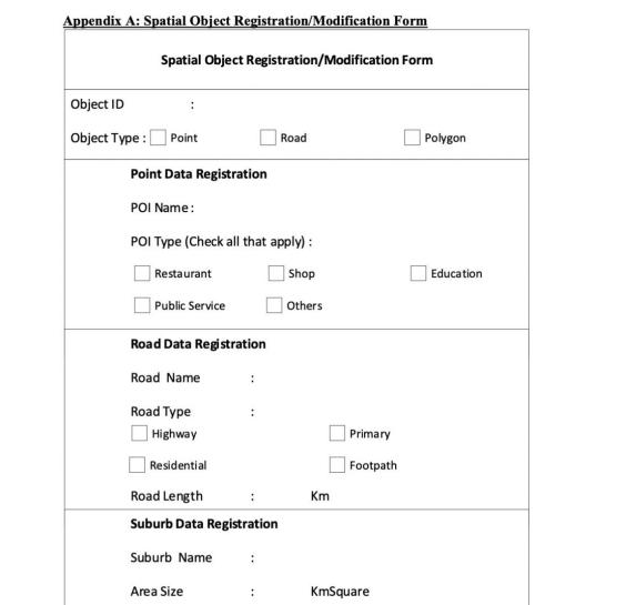
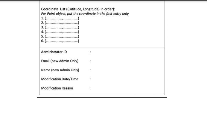
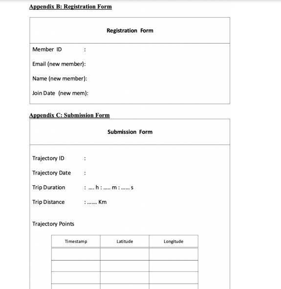
MapOnMe (MOM) is a company that aims to provide a local spatial data that can be used to analyse urban movement behaviour. For this purpose, this company provides a system where the map data is manually inserted by their staffs and trajectory data are obtained from public contributors. A trajectory is a time series of visited location point that shows a user movement in a specific of time window. A trajectory may contain numerous of trajectory points, however in some rare cases, a trajectory may consist of no trajectory points at all. For the map data, the entry is manually inserted or updated by the administrator. A spatial object can be modified several times by different administrators. For historical purposes reason, the updated date and reason must be recorded for any objects added/modified by the administrators. There are three types of objects in map data, which are Point Data, Road Data and Region Data. Each object will have a unique object identifier called "objectID". A Point data shows a location for an object such as Restaurant, Shop, Education or Public Service. Any other type of objects will be classified as Others. A Point may have multiple classifications. For example, a shop may have a restaurant in it. Each Point object will have a specific object name and the Geolocation coordinate that contains a pair of Latitude and Longitude values. A Road object is the road in the local area that might be classified as Highway, Primary, Residential or Footpath. Highway is a road normally with 2 or more running lanes plus emergency hard shoulder. This type of road is usually used to connect metropolitan area with regional area. Primary road is the main road in an area. The Residential road is the road that located in residential area which serves as an access to housing, without function of connecting settlements. The Footpath is a road restricted to pedestrian and bicycle access. Each Road entry must have road name and road length in Km. A road data is represented as a specific sequence of coordinate list. The Region data is used to represent Region in the local area. The Region data has region name, area size in SqKm and a specific sequence of coordinate list as a closed loop. A member must be registered in the system by providing preferred memberID, email and name. The date and time when a member joins as user are obtained automatically during registration. The Administrators are staffs in this company that have modification right to insert, update or delete the spatial objects. The administrators are identified by their adminID, email and name. To submit their own trajectory data, a user or an administrator must be recognized as Contributor. Only contributors can submit trajectories. Not all administrators or users are considered as contributors. Contributors will gain points for trajectories submitted to the system. When submitting the trajectory data, an automatic TrajID will be assigned to the trajectory. The member must provide the date when the trip trajectory was done. The time when a member submits the trajectory will be obtained automatically. The trip duration and trip distance will be calculated automatically based on the trajectory points provided by the member. CSE2/4DBF-Assignment 1, Part 1 Page 3/5 TASK: You are required to develop an EER model for the above problem description. The EER should contain all necessary information such as entities, attributes, primary keys, relationships (including specialization/generalization if any), cardinalities, and participation (including (min, max)). All specialization/generalization and union type must be represented accordingly, instead being treated as simple association relationships. Any assumptions should also be stated clearly. If assumptions are made, it is important to make sure that the assumptions reflect possible real practice for a particular industry and do not contradict with the problem description above. [100%] Please note the following important points before you get started: Assignment should be typed, not written/drawn by hand. Use any software to draw figures in your assignment. However, make sure to follow the notations introduced in this subject (You can try several web-based drawing platforms such as draw.io) You are NOT required to transform your EER diagram into a set of tables for this part of the assignment. You are also NOT required to perform normalization of the user views provided in the appendices. The forms in the appendices should be used as a source of supplementary information for this assignment. For example, Appendix A may give you some clarity about what information is required to be stored for a patient. Appendix A: Spatial Object Registration/Modification Form Spatial Object Registration/Modification Form Object ID Object Type: [ Point Point Data Registration POI Name: POI Type (Check all that apply): Restaurant Public Service Road Data Registration Road Name Road Type Highway Residential Road Length Suburb Data Registration Suburb Name Area Size Road : Shop Others Km Primary Footpath KmSquare Polygon Education Coordinate List ((Latitude, Longitude) In order): For Point object, put the coordinate in the first entry only 1.(.. 2. ( 3. ( 4. ( 5. ( 6. ( Administrator ID Email (new Admin Only) Name (new Admin Only) Modification Date/Time Modification Reason : : Appendix B: Registration Form Member ID Email (new member): Name (new member): Join Date (new mem): Trajectory ID Trajectory Date Appendix C: Submission Form Trip Duration Trip Distance : Trajectory Points : : Registration Form Timestamp Submission Form :...h:..... m: ......s Km Latitude Longitude MapOnMe (MOM) is a company that aims to provide a local spatial data that can be used to analyse urban movement behaviour. For this purpose, this company provides a system where the map data is manually inserted by their staffs and trajectory data are obtained from public contributors. A trajectory is a time series of visited location point that shows a user movement in a specific of time window. A trajectory may contain numerous of trajectory points, however in some rare cases, a trajectory may consist of no trajectory points at all. For the map data, the entry is manually inserted or updated by the administrator. A spatial object can be modified several times by different administrators. For historical purposes reason, the updated date and reason must be recorded for any objects added/modified by the administrators. There are three types of objects in map data, which are Point Data, Road Data and Region Data. Each object will have a unique object identifier called "objectID". A Point data shows a location for an object such as Restaurant, Shop, Education or Public Service. Any other type of objects will be classified as Others. A Point may have multiple classifications. For example, a shop may have a restaurant in it. Each Point object will have a specific object name and the Geolocation coordinate that contains a pair of Latitude and Longitude values. A Road object is the road in the local area that might be classified as Highway, Primary, Residential or Footpath. Highway is a road normally with 2 or more running lanes plus emergency hard shoulder. This type of road is usually used to connect metropolitan area with regional area. Primary road is the main road in an area. The Residential road is the road that located in residential area which serves as an access to housing, without function of connecting settlements. The Footpath is a road restricted to pedestrian and bicycle access. Each Road entry must have road name and road length in Km. A road data is represented as a specific sequence of coordinate list. The Region data is used to represent Region in the local area. The Region data has region name, area size in SqKm and a specific sequence of coordinate list as a closed loop. A member must be registered in the system by providing preferred memberID, email and name. The date and time when a member joins as user are obtained automatically during registration. The Administrators are staffs in this company that have modification right to insert, update or delete the spatial objects. The administrators are identified by their adminID, email and name. To submit their own trajectory data, a user or an administrator must be recognized as Contributor. Only contributors can submit trajectories. Not all administrators or users are considered as contributors. Contributors will gain points for trajectories submitted to the system. When submitting the trajectory data, an automatic TrajID will be assigned to the trajectory. The member must provide the date when the trip trajectory was done. The time when a member submits the trajectory will be obtained automatically. The trip duration and trip distance will be calculated automatically based on the trajectory points provided by the member. CSE2/4DBF-Assignment 1, Part 1 Page 3/5 TASK: You are required to develop an EER model for the above problem description. The EER should contain all necessary information such as entities, attributes, primary keys, relationships (including specialization/generalization if any), cardinalities, and participation (including (min, max)). All specialization/generalization and union type must be represented accordingly, instead being treated as simple association relationships. Any assumptions should also be stated clearly. If assumptions are made, it is important to make sure that the assumptions reflect possible real practice for a particular industry and do not contradict with the problem description above. [100%] Please note the following important points before you get started: Assignment should be typed, not written/drawn by hand. Use any software to draw figures in your assignment. However, make sure to follow the notations introduced in this subject (You can try several web-based drawing platforms such as draw.io) You are NOT required to transform your EER diagram into a set of tables for this part of the assignment. You are also NOT required to perform normalization of the user views provided in the appendices. The forms in the appendices should be used as a source of supplementary information for this assignment. For example, Appendix A may give you some clarity about what information is required to be stored for a patient. Appendix A: Spatial Object Registration/Modification Form Spatial Object Registration/Modification Form Object ID Object Type: [ Point Point Data Registration POI Name: POI Type (Check all that apply): Restaurant Public Service Road Data Registration Road Name Road Type Highway Residential Road Length Suburb Data Registration Suburb Name Area Size Road : Shop Others Km Primary Footpath KmSquare Polygon Education Coordinate List ((Latitude, Longitude) In order): For Point object, put the coordinate in the first entry only 1.(.. 2. ( 3. ( 4. ( 5. ( 6. ( Administrator ID Email (new Admin Only) Name (new Admin Only) Modification Date/Time Modification Reason : : Appendix B: Registration Form Member ID Email (new member): Name (new member): Join Date (new mem): Trajectory ID Trajectory Date Appendix C: Submission Form Trip Duration Trip Distance : Trajectory Points : : Registration Form Timestamp Submission Form :...h:..... m: ......s Km Latitude Longitude
Expert Answer:

Related Book For 

Accounting for Governmental and Nonprofit Entities
ISBN: 978-1259917059
18th edition
Authors: Jacqueline L. Reck, James E. Rooks, Suzanne Lowensohn, Daniel Neely
Posted Date:
Students also viewed these databases questions
-
What is the contribution of Adam Smith in Organizational Behaviour?
-
Planning is one of the most important management functions in any business. A front office managers first step in planning should involve determine the departments goals. Planning also includes...
-
Managing Scope Changes Case Study Scope changes on a project can occur regardless of how well the project is planned or executed. Scope changes can be the result of something that was omitted during...
-
You are given the following information concerning four stocks: a) Using 20X0 as the base year, construct three aggregate measures of the market that simulate the Dow Jones Industrial Average, the...
-
Angela Brennan, an accountant for Dublin Co., discovers that her supervisor, Barney Stone, made several errors last year. Overall, the errors overstated the company's net income by 15 percent. It is...
-
Calvins Barber Shops, Inc. has a monopoly on barbershop services provided on the south side of Chicago because of restrictive licensing requirements, and not because of superior operating efficiency....
-
(1) An increase in stock price causes an increase in the value of a call option. (2) An increase in exercise price causes a decrease in the value of a call option. (3) An increase in the time to...
-
Dan Aykroyd Corp. was a 30% owner of Steve Martin Company, holding 210,000 shares of Martins common stock on December 31, 2013. The investment account had the following entries. On January 2, 2014,...
-
The UAE Mainland Person company whose shares were traded on a Recognized Exchange claimed a tax deduction for a salary of AED 1 , 0 0 0 , 0 0 0 paid to the Managing Director s Executive Assistant....
-
Given the following sketches, generate an Excel spreadsheet: 1) Count the total degrees of freedom in the sketch. 2) Count the constraints 3) Provide the number of dimensions that are necessary to...
-
Find the FAS, FOB, CIF, DAT & DDP prices for the following shipment in one container: Value of product, packed for Value of product, packed for export: $40,000.00 Container rental (goes with...
-
y = (5+ cos(x))* Use Logarithmic Differentiation to find dy dx dy dx
-
ine distribution of the annual incomes of a group of middle-management employees at Compton Plastics approximates a normal distribution with a mean of $47,200 and a standard deviation of $800. (a)...
-
e. Explain the advantages of dry etching and wet etching for semiconductor fabrication processes.
-
5. A rotating component made of 70Cu-30Zn brass is subjected to a fluctuating axial load of +/- 500 N. If the component needs a fatigue life of 105 cycles, what cross-sectional area is required? (3)
-
Let A be the area of the bounded region enclosed by the parabola y = x - 27 and the line y = -6x. Then A= square units
-
Exhibit 6 Key Competitors and Inditex, 2001 Gap H&M Benetton Inditex Operating Results ( Millions) Net Operating Revenues 15,559 4,269 2,098 3,250 Cost of Goods Sold 10,904 2,064 1,189 1,563 Gross...
-
Given the table below, about how much force does the rocket engine exert on the 4.0 kg payload? Distance traveled with rocket engine firing (m) Payload final velocity (m/s) 500 320 490 310 1020 450...
-
What is a private-purpose trust fund? There are two types of assets that can be held by a private-purpose trust; what are the two types of assets and how do the asset types compare to governmental...
-
How are debt issuance costs accounted for at the fund and government-wide levels?
-
The following alphabetic listing displays selected balances in the governmental activities accounts of Westover Village as of its June 30 fiscal year-end. Prepare a (partial) statement of activities...
-
Describe the constraints on providing useful information. LO9
-
Discuss the three principles that are used to measure and record business transactions. LO10
-
Identify the four assumptions that underlie accounting. LO9

Study smarter with the SolutionInn App