

The map in Fig. G-61 depicts the present-day distribution of hypothetical continents and oceans. The map contains
Question:
The map in Fig. G-61 depicts the ‘‘present-day’’ distribution of hypothetical continents and oceans. The map contains geologic information as well as seismicity patterns, focal-mechanism solutions, and paleomagnetic sample sites. The dashed lines show traverses from which marine magnetic anomaly data were acquired, and the marine magnetic anomaly patterns for traverses A–B through K–L are shown adjacent to the map. The table summarizes paleomagnetic data from sites P1–P6. Spreading is parallel to the transform faults and perpendicular to the ocean ridges.
1. Outline all the plate boundaries using all available information.
2. Name each plate or tectonic feature for use in your discussion. Be creative.
3. Fix one plate. Describe all the other plate motions in terms of this ‘‘fixed plate’’ reference frame.
4. Write a plate tectonic history of the region shown on this map. Be succinct but be complete. Make sure that your history incorporates all of the geologic and geophysical information available to you.
Fig. G-61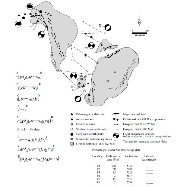
Step by Step Answer:


Structural Analysis And Synthesis A Laboratory Course In Structural Geology
ISBN: 9781405116527
3rd Edition
Authors: Stephen M. Rowland, Ernest M. Duebendorfer, Ilsa M. Schiefelbein
