

The Mercator map projection was proposed by the Flemish geographer Gerardus Mercator (15121594). The stretching factor of
Question:
The Mercator map projection was proposed by the Flemish geographer Gerardus Mercator (1512–1594). The stretching factor of the Mercator map as a function of the latitude θ is given by the function
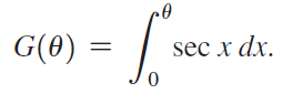
Graph G, for 0 ≤ θ < π/2.
Fantastic news! We've Found the answer you've been seeking!
Step by Step Answer:
Note that the function is equivalent to In ...View the full answer

Answered By
OTIENO OBADO
I have a vast experience in teaching, mentoring and tutoring. I handle student concerns diligently and my academic background is undeniably aesthetic
3+ Reviews
10+ Question Solved
Related Book For 
Calculus Early Transcendentals
ISBN: 978-0321947345
2nd edition
Authors: William L. Briggs, Lyle Cochran, Bernard Gillett
Question Posted:
