

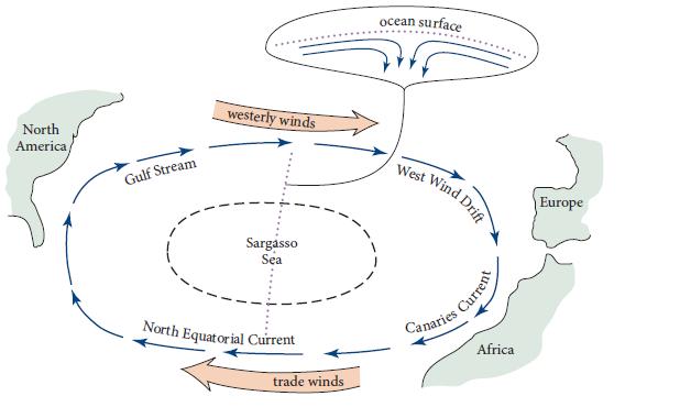
The north Atlantic Ocean exhibits the pattern of winds and ocean currents shown in Fig. 14.18. Westerly
Question:
The north Atlantic Ocean exhibits the pattern of winds and ocean currents shown in Fig. 14.18. Westerly winds blow from west to east at 40° latitude. Trade winds blow from east to west at 20° latitude. In between, around 30° latitude, is the Sargasso Sea: a 1.5-m-high gyre (raised hump of water). The gyre is created by ocean surface currents, extending down to a depth of only about 30m, that flow northward from the trade-wind region and southward from the westerly wind region (upper inset in Fig. 14.18). A deep ocean current, extending from the surface down to near the bottom, circulates around the Sargasso Sea gyre in a clockwise manner. This current goes under different names in different regions of the ocean: Gulf Stream, WestWind Drift, Canaries Current, and North Equatorial Current. Explain both qualitatively and semi quantitatively (in terms of order of magnitude) how the winds are ultimately responsible for all these features of the ocean. More specifically, do the following.
(a) Explain the surface currents in terms of an Ekman layer at the top of the ocean, with thickness δE about 30m. From this measured δE compute the kinematic viscosity ν in the boundary layer. Your result, ν ∼ 0.03m2 s−1, is far larger than the molecular viscosity of water, ∼10−6 m2 s−1 (Table 13.2). The reason is that the boundary layer is turbulent, and its eddies produce this large viscosity
(b) Explain why the height of the gyre that the surface currents produce in the Sargasso Sea is about 1.5 m.
(c) Explain the deep ocean current (Gulf Stream, etc.) in terms of a geostrophic flow, and estimate the speed of this current. This current, like circulation in a tea cup, is an example of a “secondary flow.”
(d) If there were no continents on Earth, but only an ocean of uniform depth, what would be the flow pattern of this deep current—its directions of motion at various locations around Earth, and its speeds? The continents (North America, Europe, and Africa) must be responsible for the deviation of the actual current (Gulf Stream, etc.) from this continent-free flow pattern. How do you think the continents give rise to the altered flow pattern?
Table 13.2.
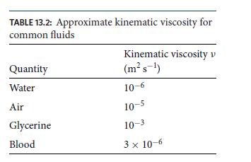
Figure 14.18.
Step by Step Answer:
a The surface currents are driven by the wind stress on the ocean surface The wind stress creates a shear flow at the top of the ocean which in turn i...View the full answer


Modern Classical Physics Optics Fluids Plasmas Elasticity Relativity And Statistical Physics
ISBN: 9780691159027
1st Edition
Authors: Kip S. Thorne, Roger D. Blandford
