

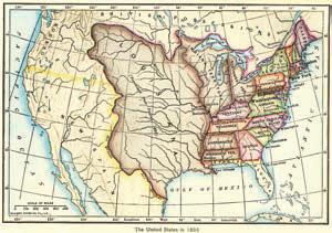
The map on page 392 shows the land purchased by the United States from France in 1803
Question:
The map on page 392 shows the land purchased by the United States from France in 1803 as part of the Louisiana Purchase. Assume the value of the land has grown at a rate of 8% per year since the land was purchased for about 4 cents, or $0.04, per acre. The value of the land per acre can be approximated by the exponential function V(t) = 0.04e0.08t. Approximate the value of the land per acre in 2020, 217 years after the purchase.
Fantastic news! We've Found the answer you've been seeking!
Step by Step Answer:
V217 004...View the full answer

Answered By
Carly Cimino
As a tutor, my focus is to help communicate and break down difficult concepts in a way that allows students greater accessibility and comprehension to their course material. I love helping others develop a sense of personal confidence and curiosity, and I'm looking forward to the chance to interact and work with you professionally and better your academic grades.
12+ Reviews
21+ Question Solved
Related Book For 

A Survey Of Mathematics With Applications
ISBN: 9780135740460
11th Edition
Authors: Allen R. Angel, Christine D. Abbott, Dennis Runde
Question Posted:
