As part of Dubai Development Plan, Roads and Transport Authority (RTA) plans to connect malls and recreational
Question:
As part of Dubai Development Plan, Roads and Transport Authority (RTA) plans to connect malls and recreational places through public transport. It has identified 10 such places whose locations are depicted in the following network diagram. The values on the arcs are the distances between locations in kilometers. The dotted lines of the network indicate that currently no road exists between those locations; however, if such locations are included in the optimum solution, the authority will construct roads between those locations. The authority wants to know how many kilometers of road it must construct to connect all the places.
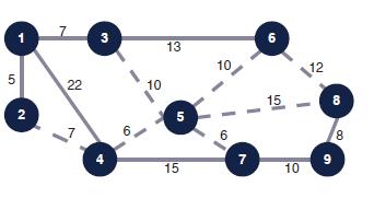
Determine the path that will connect all the facilities with minimum amount of construction and indicate the total length of the pathway.
Step by Step Answer:
Solution The path is called the minimumlength forest pat...View the full answer