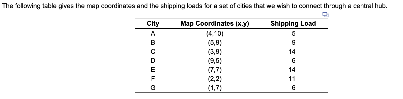
Question: 30. The following table gives the map coordinates and the shipping loads for a set of cities that we wish to connect through a central

30.

The following table gives the map coordinates and the shipping loads for a set of cities that we wish to connect through a central hub.

30. The following table gives the map coordinates

30. The following table gives the map coordinates

The following table gives the map coordinates and the shipping loads for a set of cities that we wish to connect through a central hub. City Shipping Load A B C 14 G Map Coordinates (x,y) (4,10) (5,9) (3,9) (9,5) (7,7) (2,2) (1,7) 6 14 E F 116 a) For the location of the proposed new central hub, the coordinates should be near: (round your response to two decimal places). y = (round your response to two decimal places). : b) If the shipments from city A double, for the location of the proposed new central hub, the coordinates should be near (round your response to two decimal places). X = y = (round your response to two decimal places)

Step by Step Solution

There are 3 Steps involved in it

1 Expert Approved Answer
Step: 1 Unlock blur-text-image
Question Has Been Solved by an Expert!

Get step-by-step solutions from verified subject matter experts

Step: 2 Unlock
Step: 3 Unlock

Students Have Also Explored These Related General Management Questions!