

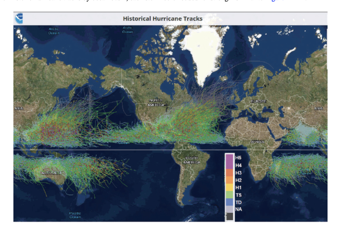
ASIA Arclic Ocean AUSTRALIA Pacific Ocean Historical Hurricane Tracks Arctic Ocean NORTEL AMERICA SOUTH AMENICA ....
Fantastic news! We've Found the answer you've been seeking!
Question:
Transcribed Image Text:
ASIA Arclic Ocean AUSTRALIA Pacific Ocean Historical Hurricane Tracks Arctic Ocean NORTEL AMERICA SOUTH AMENICA ▬▬▬▬▬▬▬▬. H5 H4 H3 H2 H1 TS TD ΝΑ EUROPE AFRICA ASIA 7. According to Figure 12A-2, tropical storms formed in either the Northern or Southern Hemispheres in Figure 12A-2.) a. do b. do not 8. This absence of tropical cyclone activity at the equator a. is b. is not a. western North Pacific b. eastern South Pacific c. South Atlantic cross the equator from one hemisphere to the other. (The equator is the white horizontal line due to the absence of the Coriolis Effect, which is essential in producing circulation during storm formation. 9. According to Figure 12A-2, tropical cyclones track through many ocean basins, and especially the Ocean. In 2018, Typhoon Jebi was the costliest typhoon to strike Japan in 25 years, causing multiple fatalities and billions of dollars in damage. In 2020, they were threatened by Typhoon Haishen, which was the third deadly typhoon in a 2-week period. The frequency of storms in this location is correlated with the large expanse of year-round warm waters. ho path on the map. 10. Click on data and view the category status of the hurricane throughout its path. You can also scroll along on the map to see the changing category, wind speeds, and pressure. The highest category rank Isaias became was a with maximum sustained winds at 75 kts (86 mph). a. H1 or category 1 b. H2 or category 2 c. H3 or category 3 For information on Atlantic and Eastern Pacific cyclones, go to the National Hurricane Center's webpage (Link 12A-4). On the menu under Archives, track maps and individual storm reports for past years can be found. Another valuable item under Educational Resources is a list of "Frequent Questions." Tropical cyclones in the mid-Pacific can be followed from the Central Pacific Hurricane Center (Link 12A-5) and those of the western Pacific at the Joint Typhoon Warning Center (Link 12A-6). Storm Surge A storm surge is a dome of ocean water topped by high waves and driven on shore by storm winds. The greatest potential for coastal flooding and beach erosion occurs along a shallow sloping shoreline when a storm surge coincides with high tide. Go to the National Hurricane Center's (NHC) main page (Link 12A-4) and scroll over Educational Resources on the top menu to open a list of life-saving information. Click on "Storm Surge" for animations of storm surge, often the most deadly aspect of hurricanes, and photographs of the damage they cause. 11. The Surge Vulnerability Facts at the bottom of the same Storm Surge Overview page states a strong hurricane with a 23-ft. storm surge coming ashore along the Gulf Coast could flood 57% of arterial roads, almost half of rail miles, 29 airports, and virtually all ports in the area. It would also risk the inundation of of interstate highways. Such input is crucial for emergency planners to order evacuations and prepare for possible destruction. In 2005 Hurricane Katrina produced a 24- to 28-ft. storm surge over a 20-mi. stretch of the Mississippi coast. a. 27% b. 49% c. 67% A weakening cyclone does not guarantee a smaller storm surge, and all precautions must be taken within the predicted landing area. p. 208 ASIA Arclic Ocean AUSTRALIA Pacific Ocean Historical Hurricane Tracks Arctic Ocean NORTEL AMERICA SOUTH AMENICA ▬▬▬▬▬▬▬▬. H5 H4 H3 H2 H1 TS TD ΝΑ EUROPE AFRICA ASIA 7. According to Figure 12A-2, tropical storms formed in either the Northern or Southern Hemispheres in Figure 12A-2.) a. do b. do not 8. This absence of tropical cyclone activity at the equator a. is b. is not a. western North Pacific b. eastern South Pacific c. South Atlantic cross the equator from one hemisphere to the other. (The equator is the white horizontal line due to the absence of the Coriolis Effect, which is essential in producing circulation during storm formation. 9. According to Figure 12A-2, tropical cyclones track through many ocean basins, and especially the Ocean. In 2018, Typhoon Jebi was the costliest typhoon to strike Japan in 25 years, causing multiple fatalities and billions of dollars in damage. In 2020, they were threatened by Typhoon Haishen, which was the third deadly typhoon in a 2-week period. The frequency of storms in this location is correlated with the large expanse of year-round warm waters. ho path on the map. 10. Click on data and view the category status of the hurricane throughout its path. You can also scroll along on the map to see the changing category, wind speeds, and pressure. The highest category rank Isaias became was a with maximum sustained winds at 75 kts (86 mph). a. H1 or category 1 b. H2 or category 2 c. H3 or category 3 For information on Atlantic and Eastern Pacific cyclones, go to the National Hurricane Center's webpage (Link 12A-4). On the menu under Archives, track maps and individual storm reports for past years can be found. Another valuable item under Educational Resources is a list of "Frequent Questions." Tropical cyclones in the mid-Pacific can be followed from the Central Pacific Hurricane Center (Link 12A-5) and those of the western Pacific at the Joint Typhoon Warning Center (Link 12A-6). Storm Surge A storm surge is a dome of ocean water topped by high waves and driven on shore by storm winds. The greatest potential for coastal flooding and beach erosion occurs along a shallow sloping shoreline when a storm surge coincides with high tide. Go to the National Hurricane Center's (NHC) main page (Link 12A-4) and scroll over Educational Resources on the top menu to open a list of life-saving information. Click on "Storm Surge" for animations of storm surge, often the most deadly aspect of hurricanes, and photographs of the damage they cause. 11. The Surge Vulnerability Facts at the bottom of the same Storm Surge Overview page states a strong hurricane with a 23-ft. storm surge coming ashore along the Gulf Coast could flood 57% of arterial roads, almost half of rail miles, 29 airports, and virtually all ports in the area. It would also risk the inundation of of interstate highways. Such input is crucial for emergency planners to order evacuations and prepare for possible destruction. In 2005 Hurricane Katrina produced a 24- to 28-ft. storm surge over a 20-mi. stretch of the Mississippi coast. a. 27% b. 49% c. 67% A weakening cyclone does not guarantee a smaller storm surge, and all precautions must be taken within the predicted landing area. p. 208
Expert Answer:
Answer rating: 100% (QA)
Ans 7 Do not Tropical storm form in one hemisphere do not cross the equator ... View the full answer

Related Book For 

Posted Date:
Students also viewed these law questions
-
Southern Atlantic Distributors began operations in January 2018 and purchased a delivery truck for $40,000. Southern Atlantic plans to use straight-line depreciation over a four-year expected useful...
-
Ocean Traders of North America is a firm based in Mobile, Alabama, that specializes in seafood exports and commonly uses letters of credit (L/Cs) to ensure payment. It recently experienced a problem,...
-
Northern Track is developing a special vehicle for Arctic exploration. The development requires investments of $60 000, $50 000, and $40 000 for the next 3 years, respectively. Net returns beginning...
-
Which of the following statements represent(s) how expenses affect equity? If expenses increase, then total equity decreases. If expenses decrease, then equity will decrease. Higher expenses result...
-
Suppose you short sell 100 shares of IBM, now selling at $120 per share. a. What is your maximum possible loss? b. What happens to the maximum loss if you simultaneously place a stop-buy order at...
-
Use the portal method and determine (approximately) the reactions at A. 3k 15 ft D 4 k 15 ft E 18 ft- -20 ft-
-
Where do you find the sources of law applicable to litigation matters? Explain the differences between the various sources of law.
-
Refer to the clustering problem involving the file FBS described in Problem 1. Apply hierarchical clustering with 10 clusters using football stadium capacity, latitude, longitude, endowment, and...
-
Describe a stressful situation you dealt with in past. What was the situation and how did you deal with it. What were your stressors? What was the outcome? positive or negative?
-
For the VOC stripping task of Exercise 6.26, the expert has suggested that we use a tower diameter of 0.80 m for which we can expect a pressure drop of 500 N/m2-m of packed height (0.612 in. H2O/ft)....
-
Subject- Optimization Techniques Q) The Farmers Bank of London is planning to install a new computerized accounts system. Bank management has determined the activities required to complete the...
-
The Shirt Shop had the following transactions for T - shirts for Year 1 , its first year of operations: January 2 0 Purchased 3 3 0 units @ $ 7 = $ 2 , 3 1 0 April 2 1 Purchased 1 5 0 units @ $ 8 = 1...
-
The current drawn by an electric motor of a fuel cell EV for a SAE Schedule D J227A driving cycle is 9.5t+1.5 A for 0
-
blossom became the year with stockholder equity of 106300. during the year blossom issued shares of stock for 146200 recorded of 417000 and paid dividends of 28300. if blossoms ending stockholder...
-
Petoskey Stone Quarry Incorporated ( PSQ ) , a calendar - year, accrual - method C corporation, provides landscaping supplies to local builders in northern Michigan. PSQ has always been a family -...
-
8. Total parking space occupied by luxury cars in Chennai malls? 20 malls (large, medium sized) Average area to park= 45 square feet Luxury cars are those which are priced above BMW 5000 vehicles are...
-
QUESTION 1 for the shape below when the object is going up, the friction force direction is P a) 35 b) c) d) diagram a diagram b diagram c diagram d 500 N
-
The manager for retail customers, Katie White, wants to hear your opinion regarding one business offer she has received from an entrepreneur who is starting a mobile phone app called Easy Money. The...
-
Find the area of each geometric figure. If the figure is a circle, give an exact area and then use the given approximation for p to approximate the area. 1. 2. 3. Use 3.14 for Ï. -25 cm- 12 cm...
-
For each food described, find the percent of total calories from fat. If necessary, round to the nearest tenth percent. Nutrition Facts Serving Size cup (33g) Servings Per Container About 9 Amount...
-
Find two other ways of naming each angle. 1. y 2. ABE (just name one other way) 15 50 45
-
Under atmospheric conditions the acetone-chloroform azeotrope boils at \(64.6^{\circ} \mathrm{C}\) and contains 33.5 mole per cent acetone. The vapour pressures of acetone and chloroform at this...
-
A system was prepared by partially decomposing \(\mathrm{CaCO}_{3}\) into an evacuated space. What is the number of degrees of freedom \((f)\) for the system?
-
Prove that chemical potentials of two phases in equilibrium are equal.

Study smarter with the SolutionInn App