

Question: Background This assignment aims to challenge students to work with basic input / output , simple data structures such as arrays and vectors, and user
Background
This assignment aims to challenge students to work with basic inputoutput simple data structures
such as arrays and vectors, and user interaction in providing them with a fun and engaging
project that combines programming skills with a bit of creativity from CSor any programming
class that you have taken at a different institution You will also practice reading CSV files for
the first, second, third, or fourth time. Note that the output of your program will be two printed
maps an outline of the United States map and the same outline with statescities superimposed
on it and the interactions between the user and your program.
Requirements
ASCII Map Generator:
The program must create a visual representation of the United States map using ASCII
characters. Each statecity should be represented with its corresponding label.
The map should be display on the terminalconsole maintaining the relative geograph
ical positions of the states.
User Interaction:
Implement a userfriendly interface that prompts the user to input the name of a state.
The program should handle both uppercase and lowercase inputs, and it should provide
error handling for invalid inputs.
State Information Retrieval:
Design your code with modular functions to enhance readability and maintainability.
Implement proper documentation and comments to explain the code logic and function
alities.
Data Structures:
Utilize appropriate data structures to store information about the states and their cor
responding details.
The only data structures that you are allowed to use for this programming assignment
are arrays andor vectors.
Error Handling:
Implement error handling mechanism to deal with invalid input and guide the user in
case of mistakes.
Your program should never terminate from an invalid name of a city. Instead, it ought
to "guess" what the user meant to type when searching for a city by providing a possible
answer or a list of possible answers.Assessment Criteria
Correctness and functionality of the ACII map generation.
User interface design and interaction.
Accuracy and completeness of statecity information retrieval.
Code structure, modularity, and documentation.
Creativity in implementing optional features.
A grade penalty will be applied for any hardcoded values.
Input Files
The program is designed to open and read two CSV files through commandline arguments. The
file named boundary csv serves as the input, containing geographic coordinates of locations along
the United States border. Each line in the file represents one coordinate, comprising two double
values separated by a comma. An example is provided below:
In contrast, the city.csv input file comprises statecity names along with their corresponding
geographic coordinates. Each line in the file includes a city name, a state abbreviation, and the
latitude and longitude of the city's geographic coordinates, all separated by commas. An example
is illustrated below:
Aberdeen SD
Albuquerque, NM
Allentown PA
Arlington, VA
Ashland, OR
Atlanta, GA
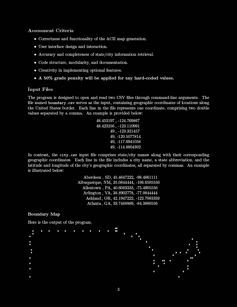
Boundary Map
Here is the output of the program.
Step by Step Solution
There are 3 Steps involved in it
1 Expert Approved Answer
Step: 1 Unlock

Question Has Been Solved by an Expert!
Get step-by-step solutions from verified subject matter experts
Step: 2 Unlock
Step: 3 Unlock