

Question: Caclucate the map coordinates of the missing data (-9999) for this raster dataset. Hint: Esri Raster is based on Cartesian coordinate system but you need
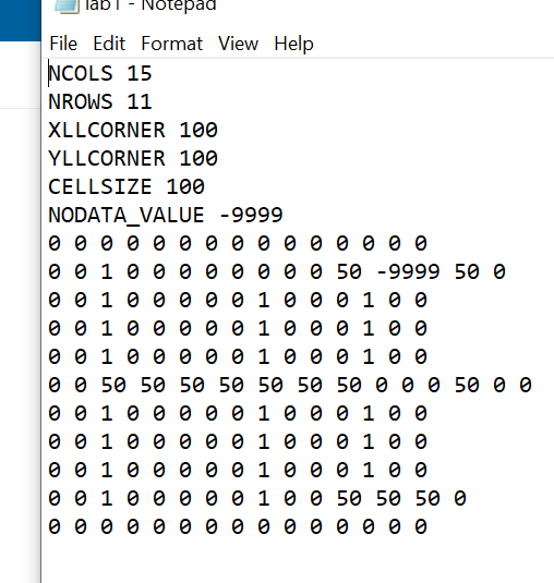
Caclucate the map coordinates of the "missing data" (-9999) for this raster dataset.
Hint: Esri Raster is based on Cartesian coordinate system but you need to consider the origin coordinate and the cell size in order to calculate the map coordinates of the "missing data"
lab Notepad - File Edit Format View Help NCOLS 15 | NROWS 11 XLLCORNER 100 YLLCORNER 100 CELLSIZE 100 NODATA_VALUE -9999 1 50 -9999 50 0 ee1eeeee1e0e1oo eeeeeee1eee1ee 1 1 1 0 0 50 50 50 50 50 50 50 0 0 0 50 0 0 000 1 1 1 1 1 1 ee1eeeee1eee1ee ee1eeeee1e0 0 0 1 0 0 0 0 0 1 0 0 50 50 50 0 lab Notepad - File Edit Format View Help NCOLS 15 | NROWS 11 XLLCORNER 100 YLLCORNER 100 CELLSIZE 100 NODATA_VALUE -9999 1 50 -9999 50 0 ee1eeeee1e0e1oo eeeeeee1eee1ee 1 1 1 0 0 50 50 50 50 50 50 50 0 0 0 50 0 0 000 1 1 1 1 1 1 ee1eeeee1eee1ee ee1eeeee1e0 0 0 1 0 0 0 0 0 1 0 0 50 50 50 0
Step by Step Solution
There are 3 Steps involved in it

Get step-by-step solutions from verified subject matter experts