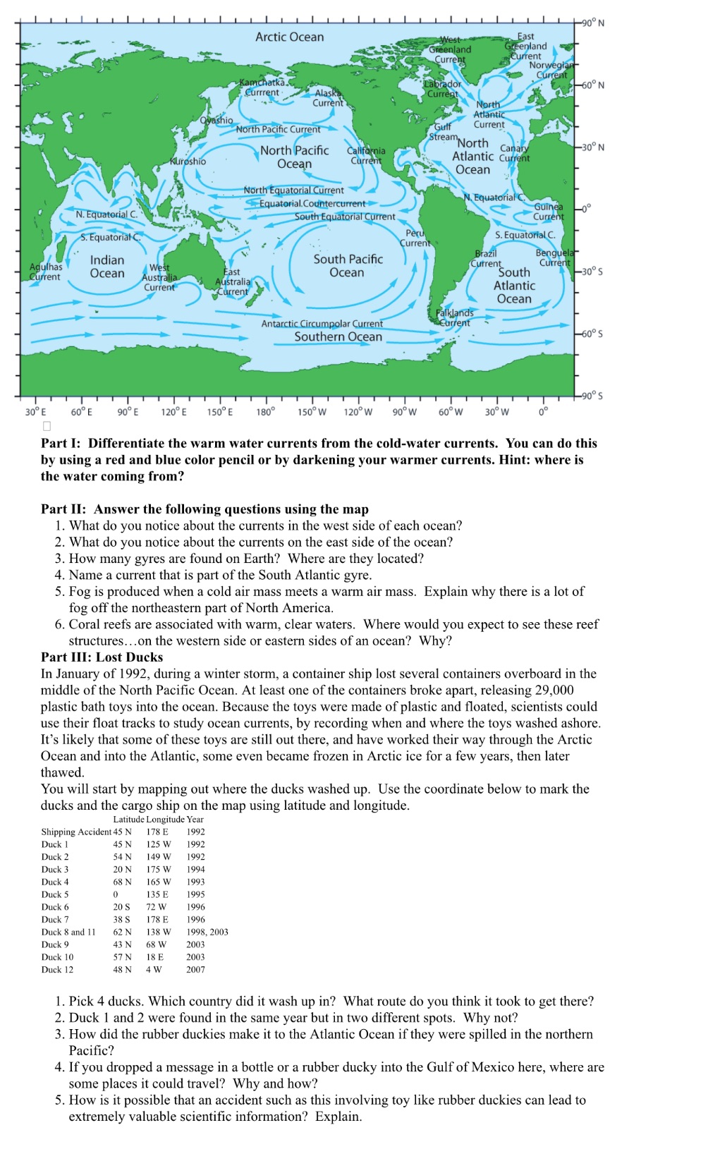
Question: Can you please answer this for me using the map in super easy words everything please !! 190 N Arctic Ocean West East Greenland Greenland

Can you please answer this for me using the map in super easy words everything please !!

Can you please answer this for me using the map
190 N Arctic Ocean West East Greenland Greenland Current Current Norwegian Kamchatka_ Current brador Current . Alask 60 0 N Current North Qyashio Atlantic North Pacific Current Gulf Current North Pacific StreamNorth California Canary -30 N Kuroshio Ocean Current Atlantic Current Ocean North Equatorial Current Equatorial.Countercurrent Equatorial C. N. Equatorial C. Guinea South Equatorial Current Curren S. Equatorial C Peru S. Equatorial C Current Indian South Pacific Brazil Benguel Agulhas West Current Current Current Ocean Australia East Ocean South -30''S Current ustralia Current Atlantic Ocean Falklands Antarctic Circumpolar Current Current Southern Ocean -60% S o's 30% E 60% E 90 0 E 120 E 150 E 180 150 W 120 W 90 W 60 W 30 0 W Part I: Differentiate the warm water currents from the cold-water currents. You can do this by using a red and blue color pencil or by darkening your warmer currents. Hint: where is the water coming from? Part II: Answer the following questions using the map 1. What do you notice about the currents in the west side of each ocean? 2. What do you notice about the currents on the east side of the ocean? 3. How many gyres are found on Earth? Where are they located? 4. Name a current that is part of the South Atlantic gyre. 5. Fog is produced when a cold air mass meets a warm air mass. Explain why there is a lot of fog off the northeastern part of North America. 6. Coral reefs are associated with warm, clear waters. Where would you expect to see these reef structures...on the western side or eastern sides of an ocean? Why? Part III: Lost Ducks In January of 1992, during a winter storm, a container ship lost several containers overboard in the middle of the North Pacific Ocean. At least one of the containers broke apart, releasing 29,000 plastic bath toys into the ocean. Because the toys were made of plastic and floated, scientists could use their float tracks to study ocean currents, by recording when and where the toys washed ashore. It's likely that some of these toys are still out there, and have worked their way through the Arctic Ocean and into the Atlantic, some even became frozen in Arctic ice for a few years, then later thawed. You will start by mapping out where the ducks washed up. Use the coordinate below to mark the ducks and the cargo ship on the map using latitude and longitude. Latitude Longitude Year Shipping Accident 45 N 178 E 1992 Duck 1 45 N 125 W 1992 Duck 2 54 N 149 W 1992 Duck 3 20 N 175 W 1994 Duck 4 68 N 165 W 1993 Duck 5 135 E 1995 Duck 6 20 S 72 W 1996 Duck 7 38 S 178 E 1996 Duck 8 and 11 52 N 138 W 1998, 2003 Duck 9 43 68 W 2003 Duck 10 57 N 18 E 2003 Duck 12 48 N 4 W 2007 1. Pick 4 ducks. Which country did it wash up in? What route do you think it took to get there? 2. Duck 1 and 2 were found in the same year but in two different spots. Why not? 3. How did the rubber duckies make it to the Atlantic Ocean if they were spilled in the northern Pacific? 4. If you dropped a message in a bottle or a rubber ducky into the Gulf of Mexico here, where are some places it could travel? Why and how? 5. How is it possible that an accident such as this involving toy like rubber duckies can lead to extremely valuable scientific information? Explain

Step by Step Solution

There are 3 Steps involved in it

1 Expert Approved Answer
Step: 1 Unlock blur-text-image
Question Has Been Solved by an Expert!

Get step-by-step solutions from verified subject matter experts

Step: 2 Unlock
Step: 3 Unlock

Students Have Also Explored These Related Law Questions!