

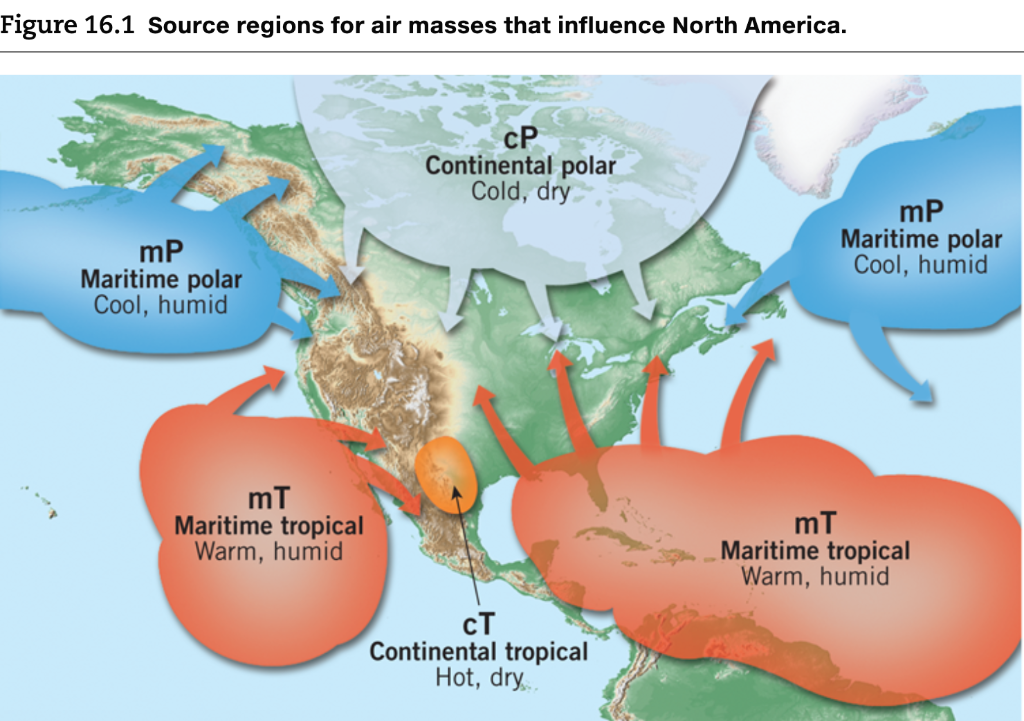
Figure 16.1 Source regions for air masses that influence North America. mP Maritime polar Cool, humid...
Fantastic news! We've Found the answer you've been seeking!
Question:
Transcribed Image Text:
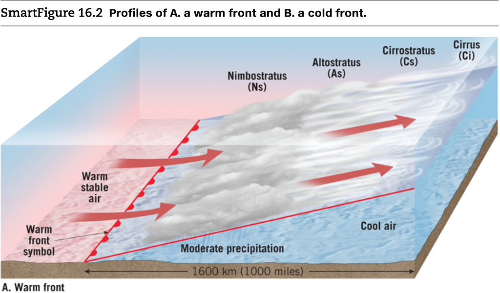
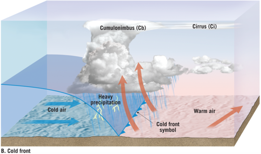
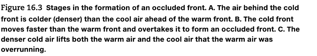
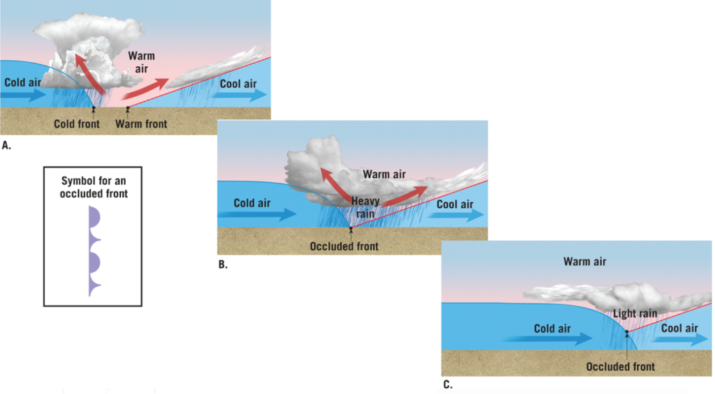
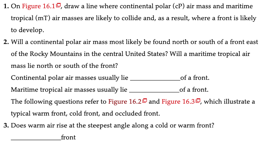
Figure 16.1 Source regions for air masses that influence North America. mP Maritime polar Cool, humid mT Maritime tropical Warm, humid cP Continental polar Cold, dry CT Continental tropical Hot, dry.. mP Maritime polar Cool, humid mT Maritime tropical Warm, humid SmartFigure 16.2 Profiles of A. a warm front and B. a cold front. Warm front symbol A. Warm front Warm stable air Nimbostratus (Ns) Moderate precipitation 1600 km (1000 miles) Altostratus (As) Cirrostratus (Cs) Cool air Cirrus (Ci) B. Cold front Cold air Cumulonimbus (Cb) Heavy precipitation Cold front symbol Cirrus (Ci) Warm air Figure 16.3 Stages in the formation of an occluded front. A. The air behind the cold front is colder (denser) than the cool air ahead of the warm front. B. The cold front moves faster than the warm front and overtakes it to form an occluded front. C. The denser cold air lifts both the warm air and the cool air that the warm air was overrunning. Cold air A. Warm air Cold front Warm front Symbol for an occluded front Cool air B. Cold air Warm air Heavy rain Occluded front Cool air C. Warm air Cold air Light rain Occluded front Cool air 1. On Figure 16.10, draw a line where continental polar (cP) air mass and maritime tropical (mT) air masses are likely to collide and, as a result, where a front is likely to develop. 2. Will a continental polar air mass most likely be found north or south of a front east of the Rocky Mountains in the central United States? Will a maritime tropical air mass lie north or south of the front? Continental polar air masses usually lie of a front. Maritime tropical air masses usually lie of a front. The following questions refer to Figure 16.2 and Figure 16.30, which illustrate a typical warm front, cold front, and occluded front. 3. Does warm air rise at the steepest angle along a cold or warm front? front 4. Are extensive areas of nimbostratus clouds and periods of prolonged precipitation most likely to occur along a cold or warm front? Explain why you expect longer periods of precipitation to be associated with this type of front. 5. Assume that the fronts are moving from left to right in Figure 16.2A,B. Is a drop in temperature most likely to occur with the passage of a cold or warm front? 6. Is a cold or warm front most likely to produce clouds of vertical development and perhaps thunderstorms? 7. Do clouds gradually become lower, thicker, and cover more of the sky as a cold front approaches or as warm front approaches? 8. During the development of an occluded front, is the cold or warm front advancing most rapidly? 9. What happens to the warm (mT) air during the development of an occluded front? (Hint: See Figure 16.30.) 10. Sketch the symbols for a cold front, a warm front, and an occluded front in the space below. (Hint: See Figures 16.20 and 16.30.) Cold front: Warm front: Occluded front: Figure 16.1 Source regions for air masses that influence North America. mP Maritime polar Cool, humid mT Maritime tropical Warm, humid cP Continental polar Cold, dry CT Continental tropical Hot, dry.. mP Maritime polar Cool, humid mT Maritime tropical Warm, humid SmartFigure 16.2 Profiles of A. a warm front and B. a cold front. Warm front symbol A. Warm front Warm stable air Nimbostratus (Ns) Moderate precipitation 1600 km (1000 miles) Altostratus (As) Cirrostratus (Cs) Cool air Cirrus (Ci) B. Cold front Cold air Cumulonimbus (Cb) Heavy precipitation Cold front symbol Cirrus (Ci) Warm air Figure 16.3 Stages in the formation of an occluded front. A. The air behind the cold front is colder (denser) than the cool air ahead of the warm front. B. The cold front moves faster than the warm front and overtakes it to form an occluded front. C. The denser cold air lifts both the warm air and the cool air that the warm air was overrunning. Cold air A. Warm air Cold front Warm front Symbol for an occluded front Cool air B. Cold air Warm air Heavy rain Occluded front Cool air C. Warm air Cold air Light rain Occluded front Cool air 1. On Figure 16.10, draw a line where continental polar (cP) air mass and maritime tropical (mT) air masses are likely to collide and, as a result, where a front is likely to develop. 2. Will a continental polar air mass most likely be found north or south of a front east of the Rocky Mountains in the central United States? Will a maritime tropical air mass lie north or south of the front? Continental polar air masses usually lie of a front. Maritime tropical air masses usually lie of a front. The following questions refer to Figure 16.2 and Figure 16.30, which illustrate a typical warm front, cold front, and occluded front. 3. Does warm air rise at the steepest angle along a cold or warm front? front 4. Are extensive areas of nimbostratus clouds and periods of prolonged precipitation most likely to occur along a cold or warm front? Explain why you expect longer periods of precipitation to be associated with this type of front. 5. Assume that the fronts are moving from left to right in Figure 16.2A,B. Is a drop in temperature most likely to occur with the passage of a cold or warm front? 6. Is a cold or warm front most likely to produce clouds of vertical development and perhaps thunderstorms? 7. Do clouds gradually become lower, thicker, and cover more of the sky as a cold front approaches or as warm front approaches? 8. During the development of an occluded front, is the cold or warm front advancing most rapidly? 9. What happens to the warm (mT) air during the development of an occluded front? (Hint: See Figure 16.30.) 10. Sketch the symbols for a cold front, a warm front, and an occluded front in the space below. (Hint: See Figures 16.20 and 16.30.) Cold front: Warm front: Occluded front: Figure 16.1 Source regions for air masses that influence North America. mP Maritime polar Cool, humid mT Maritime tropical Warm, humid cP Continental polar Cold, dry CT Continental tropical Hot, dry.. mP Maritime polar Cool, humid mT Maritime tropical Warm, humid SmartFigure 16.2 Profiles of A. a warm front and B. a cold front. Warm front symbol A. Warm front Warm stable air Nimbostratus (Ns) Moderate precipitation 1600 km (1000 miles) Altostratus (As) Cirrostratus (Cs) Cool air Cirrus (Ci) B. Cold front Cold air Cumulonimbus (Cb) Heavy precipitation Cold front symbol Cirrus (Ci) Warm air Figure 16.3 Stages in the formation of an occluded front. A. The air behind the cold front is colder (denser) than the cool air ahead of the warm front. B. The cold front moves faster than the warm front and overtakes it to form an occluded front. C. The denser cold air lifts both the warm air and the cool air that the warm air was overrunning. Cold air A. Warm air Cold front Warm front Symbol for an occluded front Cool air B. Cold air Warm air Heavy rain Occluded front Cool air C. Warm air Cold air Light rain Occluded front Cool air 1. On Figure 16.10, draw a line where continental polar (cP) air mass and maritime tropical (mT) air masses are likely to collide and, as a result, where a front is likely to develop. 2. Will a continental polar air mass most likely be found north or south of a front east of the Rocky Mountains in the central United States? Will a maritime tropical air mass lie north or south of the front? Continental polar air masses usually lie of a front. Maritime tropical air masses usually lie of a front. The following questions refer to Figure 16.2 and Figure 16.30, which illustrate a typical warm front, cold front, and occluded front. 3. Does warm air rise at the steepest angle along a cold or warm front? front 4. Are extensive areas of nimbostratus clouds and periods of prolonged precipitation most likely to occur along a cold or warm front? Explain why you expect longer periods of precipitation to be associated with this type of front. 5. Assume that the fronts are moving from left to right in Figure 16.2A,B. Is a drop in temperature most likely to occur with the passage of a cold or warm front? 6. Is a cold or warm front most likely to produce clouds of vertical development and perhaps thunderstorms? 7. Do clouds gradually become lower, thicker, and cover more of the sky as a cold front approaches or as warm front approaches? 8. During the development of an occluded front, is the cold or warm front advancing most rapidly? 9. What happens to the warm (mT) air during the development of an occluded front? (Hint: See Figure 16.30.) 10. Sketch the symbols for a cold front, a warm front, and an occluded front in the space below. (Hint: See Figures 16.20 and 16.30.) Cold front: Warm front: Occluded front: Figure 16.1 Source regions for air masses that influence North America. mP Maritime polar Cool, humid mT Maritime tropical Warm, humid cP Continental polar Cold, dry CT Continental tropical Hot, dry.. mP Maritime polar Cool, humid mT Maritime tropical Warm, humid SmartFigure 16.2 Profiles of A. a warm front and B. a cold front. Warm front symbol A. Warm front Warm stable air Nimbostratus (Ns) Moderate precipitation 1600 km (1000 miles) Altostratus (As) Cirrostratus (Cs) Cool air Cirrus (Ci) B. Cold front Cold air Cumulonimbus (Cb) Heavy precipitation Cold front symbol Cirrus (Ci) Warm air Figure 16.3 Stages in the formation of an occluded front. A. The air behind the cold front is colder (denser) than the cool air ahead of the warm front. B. The cold front moves faster than the warm front and overtakes it to form an occluded front. C. The denser cold air lifts both the warm air and the cool air that the warm air was overrunning. Cold air A. Warm air Cold front Warm front Symbol for an occluded front Cool air B. Cold air Warm air Heavy rain Occluded front Cool air C. Warm air Cold air Light rain Occluded front Cool air 1. On Figure 16.10, draw a line where continental polar (cP) air mass and maritime tropical (mT) air masses are likely to collide and, as a result, where a front is likely to develop. 2. Will a continental polar air mass most likely be found north or south of a front east of the Rocky Mountains in the central United States? Will a maritime tropical air mass lie north or south of the front? Continental polar air masses usually lie of a front. Maritime tropical air masses usually lie of a front. The following questions refer to Figure 16.2 and Figure 16.30, which illustrate a typical warm front, cold front, and occluded front. 3. Does warm air rise at the steepest angle along a cold or warm front? front 4. Are extensive areas of nimbostratus clouds and periods of prolonged precipitation most likely to occur along a cold or warm front? Explain why you expect longer periods of precipitation to be associated with this type of front. 5. Assume that the fronts are moving from left to right in Figure 16.2A,B. Is a drop in temperature most likely to occur with the passage of a cold or warm front? 6. Is a cold or warm front most likely to produce clouds of vertical development and perhaps thunderstorms? 7. Do clouds gradually become lower, thicker, and cover more of the sky as a cold front approaches or as warm front approaches? 8. During the development of an occluded front, is the cold or warm front advancing most rapidly? 9. What happens to the warm (mT) air during the development of an occluded front? (Hint: See Figure 16.30.) 10. Sketch the symbols for a cold front, a warm front, and an occluded front in the space below. (Hint: See Figures 16.20 and 16.30.) Cold front: Warm front: Occluded front:
Expert Answer:

Related Book For 

Conceptual Physical Science
ISBN: 978-0134060491
6th edition
Authors: Paul G. Hewitt, John A. Suchocki, Leslie A. Hewitt
Posted Date:
Students also viewed these physics questions
-
Read the case study and answer the question below with a one page response. What does a SWOT analysis reveal about the overall attractiveness of Under Armours situation? Founded in 1996 by former...
-
Why have some firms gone to voluntary benefits as opposed to discretionary benefits?
-
Back in Boston, Steve has been busy creating and managing his new company, Teton Mountaineering (TM), which is based out of a small town in Wyoming. In the process of doing so, TM has acquired...
-
From a random sample of 36 business days from February 24, 2016, through February 24, 2017, the mean closing price of Apple stock was $116.16. Assume the population standard deviation is $10.27. You...
-
Hooters Restaurant in Myrtle Beach, South Carolina, used an alternative dispute resolution program, a program to resolve disputes outside the traditional court system. Employees of Hooters had to...
-
Bug-Off Exterminators provides pest control services and sells extermination products manufactured by other companies. The following six-column table contains the companys unadjusted trial balance as...
-
Database design is quite complex and important. Discuss the role played by users during the design process Describe the purpose of normalizing data Briefly describe the basic SQL DDL statements and...
-
Your investment bank has an investment of $100 million in the stock of the Swiss Roll Corporation and a short position in the stock of the Frankfurter Sausage Company. Here is the recent price...
-
An experiment was conducted to determine the thermal maximum temperature for two different species of ants. Below are 25 random samples from a larger population of the two species. Determine the 95%...
-
Russ, Don, Pamela, and Stephanie are the first names of four friends who all received sports scholarships. Krieger actually has a full ride, because he is a star in two different sports. Use the...
-
1. Is a growing trade deficit a concern for the United States economy? Explain why! 2.Explain how a mixed economy is a mixture of command and pure market economy. 3. Discuss the role of government in...
-
Stetson's most expensive cowboy hat costs $5000. If you take out a 5-year add-on loan to buy the hat with monthly payments of $170, what is the interest rate on the loan? Enter your answer as...
-
Social and personal resources students carry with them are part of what form of community cultural wealth?
-
Look around carefully, paying close attention to any objects that you have never noticed, and/or objects that make you feel uncomfortable. Could one of them be a Tsukuyomi? Next, sit down with your...
-
The following random variables X1, X2, .. Xn are independent and have density function (x) = hex (x> 0). Show that the conjugate prior distribution for 2 is a gamma distribution and determine its...
-
DC has unused FTC carryover from 2017 in the separate category for GC income as the result of income generated by a foreign branch. The income was foreign source general category income. In 2018 the...
-
If we cant even predict the weather, how can we ever expect to predict the fate of the universe?
-
What evidence do we have of Precambrian life?
-
Rank in order of decreasing number of people who have seen a: (a) Solar eclipse, (b) Lunar eclipse, (c) New Moon.
-
A single-tank liquid-level system with inflow rate \(q_{i}\) as its input and liquid level \(h\) as its output is modeled as \(R A \dot{h}+g h=R q_{i}(t), h(0)=0\), where \(R, A, g=\) const. If the...
-
The mechanical system in Figure 8.37, where all parameter values are in consistent physical units, is subject to initial conditions \(x_{1}(0)=1, x_{2}(0)=1, \dot{x}_{1}(0)=-1, \dot{x}_{2}(0)=1\)....
-
A dynamic system is modeled as \[4 \ddot{x}+4 \dot{x}+5 x=10 \sin \left(\frac{1}{2} t ight), \quad x(0)=\frac{1}{2}, \quad \dot{x}(0)=0\] Plot the response \(x(t)\) for \(0 \leq t \leq 20\) by a....

Study smarter with the SolutionInn App