

Question: For developing Calvert Crossings project in a manner that will attract the best tenants, we need an easement across the neighboring parcel owned by Darcy,
For developing Calvert Crossings project in a manner that will attract the best tenants, we need an easement across the neighboring parcel owned by Darcy, LLC,
Based on the attached Exhibit A, is the legal description accurate in terms of including the entire property?
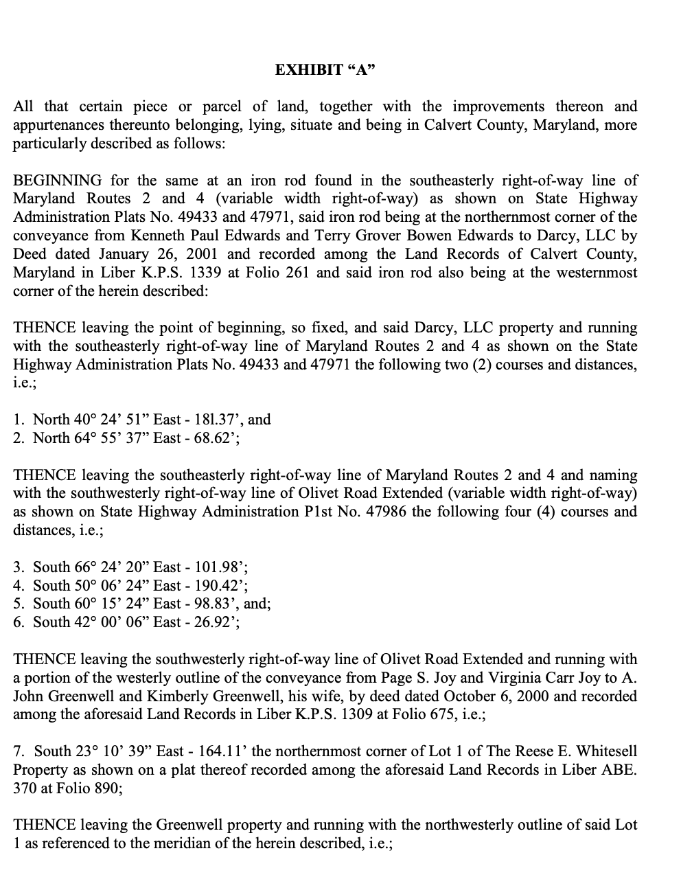
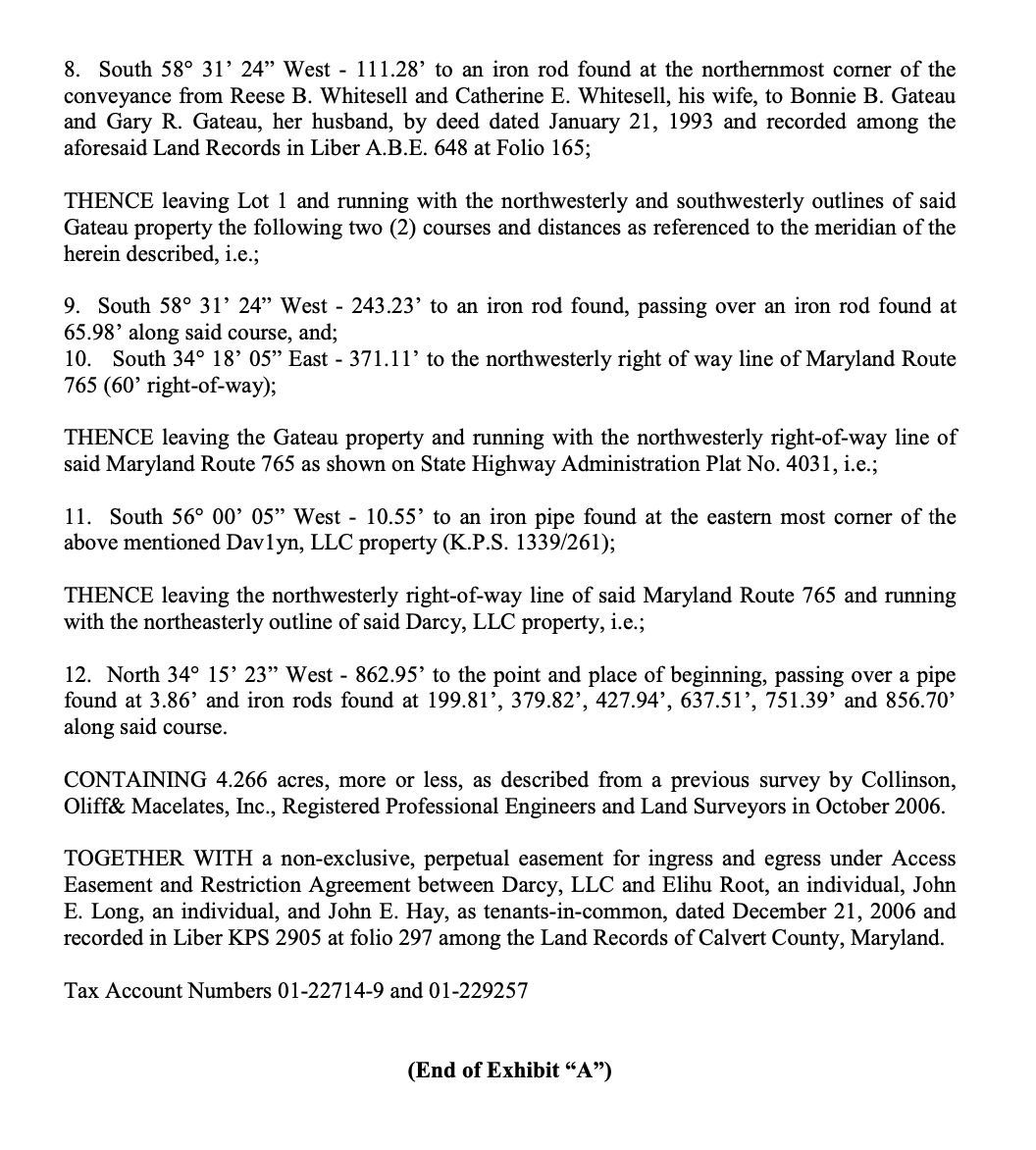
EXHIBIT "A" All that certain piece or parcel of land, together with the improvements thereon and appurtenances thereunto belonging, lying, situate and being in Calvert County, Maryland, more particularly described as follows: BEGINNING for the same at an iron rod found in the southeasterly right-of-way line of Maryland Routes 2 and 4 (variable width right-of-way) as shown on State Highway Administration Plats No. 49433 and 47971, said iron rod being at the northernmost corner of the conveyance from Kenneth Paul Edwards and Terry Grover Bowen Edwards to Darcy, LLC by Deed dated January 26, 2001 and recorded among the Land Records of Calvert County, Maryland in Liber K.P.S. 1339 at Folio 261 and said iron rod also being at the westernmost corner of the herein described: THENCE leaving the point of beginning, so fixed, and said Darcy, LLC property and running with the southeasterly right-of-way line of Maryland Routes 2 and 4 as shown on the State Highway Administration Plats No. 49433 and 47971 the following two (2) courses and distances, i.e.; 1. North 40 24' 51" East - 181.37', and 2. North 64 55' 37" East - 68.62'; THENCE leaving the southeasterly right-of-way line of Maryland Routes 2 and 4 and naming with the southwesterly right-of-way line of Olivet Road Extended (variable width right-of-way) as shown on State Highway Administration PIst No. 47986 the following four (4) courses and distances, i.e.; 3. South 66 24' 20" East - 101.98'; 4. South 50 06' 24" East - 190.42'; 5. South 60 15' 24" East - 98.83', and; 6. South 42 00' 06" East - 26.92'; THENCE leaving the southwesterly right-of-way line of Olivet Road Extended and running with a portion of the westerly outline of the conveyance from Page S. Joy and Virginia Carr Joy to A. John Greenwell and Kimberly Greenwell, his wife, by deed dated October 6, 2000 and recorded among the aforesaid Land Records in Liber K.P.S. 1309 at Folio 675, i.e.; 7. South 23 10' 39" East - 164.11' the northernmost corner of Lot 1 of The Reese E. Whitesell Property as shown on a plat thereof recorded among the aforesaid Land Records in Liber ABE. 370 at Folio 890; THENCE leaving the Greenwell property and running with the northwesterly outline of said Lot 1 as referenced to the meridian of the herein described, i.e.;8. South 58 31' 24" West - 111.28' to an iron rod found at the northernmost corner of the conveyance from Reese B. Whitesell and Catherine E. Whitesell, his wife, to Bonnie B. Gateau and Gary R. Gateau, her husband, by deed dated January 21, 1993 and recorded among the aforesaid Land Records in Liber A.B.E. 648 at Folio 165; THENCE leaving Lot 1 and running with the northwesterly and southwesterly outlines of said Gateau property the following two (2) courses and distances as referenced to the meridian of the herein described, i.e.; 9. South 58 31' 24" West - 243.23' to an iron rod found, passing over an iron rod found at 65.98' along said course, and; 10. South 34 18' 05" East - 371.11' to the northwesterly right of way line of Maryland Route 765 (60' right-of-way); THENCE leaving the Gateau property and running with the northwesterly right-of-way line of said Maryland Route 765 as shown on State Highway Administration Plat No. 4031, i.e.; 11. South 56 00' 05" West - 10.55' to an iron pipe found at the eastern most corner of the above mentioned Davlyn, LLC property (K.P.S. 1339/261); THENCE leaving the northwesterly right-of-way line of said Maryland Route 765 and running with the northeasterly outline of said Darcy, LLC property, i.e.; 12. North 34 15' 23" West - 862.95' to the point and place of beginning, passing over a pipe found at 3.86' and iron rods found at 199.81', 379.82', 427.94', 637.51', 751.39' and 856.70' along said course. CONTAINING 4.266 acres, more or less, as described from a previous survey by Collinson, Oliff& Macelates, Inc., Registered Professional Engineers and Land Surveyors in October 2006. TOGETHER WITH a non-exclusive, perpetual easement for ingress and egress under Access Easement and Restriction Agreement between Darcy, LLC and Elihu Root, an individual, John E. Long, an individual, and John E. Hay, as tenants-in-common, dated December 21, 2006 and recorded in Liber KPS 2905 at folio 297 among the Land Records of Calvert County, Maryland. Tax Account Numbers 01-22714-9 and 01-229257 (End of Exhibit "A")
Step by Step Solution
There are 3 Steps involved in it

Get step-by-step solutions from verified subject matter experts