

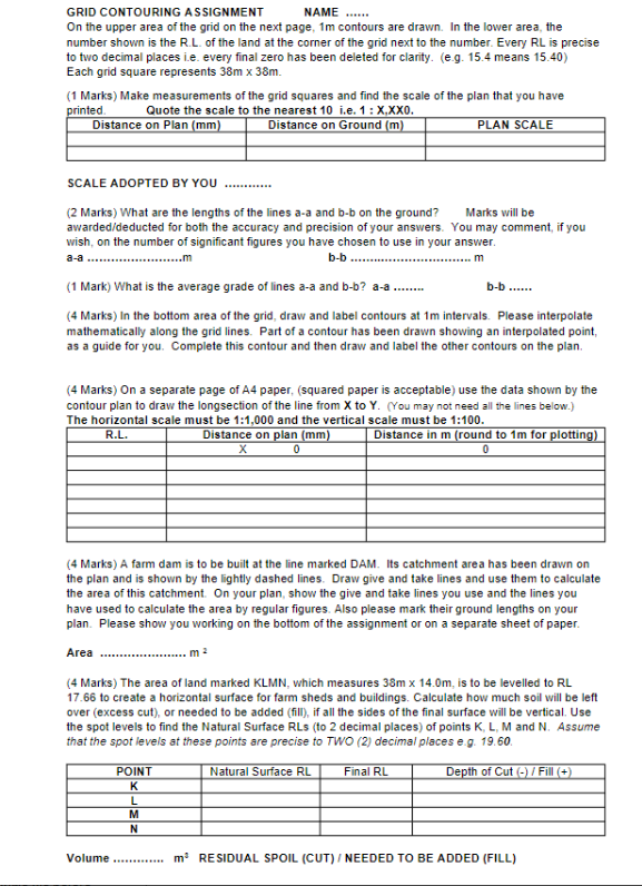
Question: GRID CONTOURING ASSIGNMEN.GRID CONTOURING ASSIGNMENT NAME . . . . . . On the upper area of the grid on the next page, 1 m
GRID CONTOURING ASSIGNMEN.GRID CONTOURING ASSIGNMENT
NAME
On the upper area of the grid on the next page, contours are drawn. In the lower area, the
number shown is the RL of the land at the corner of the grid next to the number. Every RL is precise
to two decimal places ie every final zero has been deleted for clarity. eg means
Each grid square represents
Marks Make measurements of the grid squares and find the scale of the plan that you have
printed. Quote the scale to the nearest ie:
SCALE ADOPTED BY YOU
Marks What are the lengths of the lines aa and bb on the ground? Marks will be
awardeddeducted for both the accuracy and precision of your answers. You may comment, if you
wish, on the number of significant figures you have chosen to use in your answer.
aa
m
bb
Mark What is the average grade of lines a and
bb
Marks In the bottom area of the grid, draw and label contours at intervals. Please interpolate
mathematically along the grid lines. Part of a contour has been drawn showing an interpolated point,
as a guide for you. Complete this contour and then draw and label the other contours on the plan.
Marks On a separate page of A paper, squared paper is acceptable use the data shown by the
contour plan to draw the longsection of the line from to You may not need all the lines below.
The horizontal scale must be : and the vertical scale must be :
Marks A farm dam is to be built at the line marked DAM. Its catchment area has been drawn on
the plan and is shown by the lightly dashed lines. Draw give and take lines and use them to calculate
the area of this catchment. On your plan, show the give and take lines you use and the lines you
have used to calculate the area by regular figures. Also please mark their ground lengths on your
plan. Please show you working on the bottom of the assignment or on a separate sheet of paper.
Area
Marks The area of land marked KLMN which measures is to be levelled to RL
to create a horizontal surface for farm sheds and buildings. Calculate how much soil will be left
over excess cut or needed to be added fill if all the sides of the final surface will be vertical. Use
the spot levels to find the Natural Surface RLs to decimal places of points K L M and N Assume
that the spot levels at these points are precise to TWO decimal places eg
Step by Step Solution
There are 3 Steps involved in it
1 Expert Approved Answer
Step: 1 Unlock

Question Has Been Solved by an Expert!
Get step-by-step solutions from verified subject matter experts
Step: 2 Unlock
Step: 3 Unlock