

Question: HI, I am having issues with my geolocation python project. Some parts will not run and I cannot figure out what is wrong. Below I
HI, I am having issues with my geolocation python project. Some parts will not run and I cannot figure out what is wrong. Below I have attached what I have done so far. If you need more information about the project, feel free to ask me and I will provide the missing information. Thank you in advance for your help.
geolocation.py
-------------------------------------------------------------------------------------------------------------------------------------------
geolocator.py
# This class provides a single static method called find that provides access
# to the Google Maps api. It takes a search string and returns the latitude
# and longitude of the top hit for the search. Returns null if the search
# produces no results or if no internet connection is available.
#
# Sample calls:
# location = GeoLocator.find("space needle")
# location = GeoLocator.find_place("space needle")
import urllib
import urllib.request
import urllib.parse
import xml.etree.ElementTree as et
from place_information import *
from geolocation import *
class GeoLocator:
# Given a query string, returns a GeoLocation representing the coordinates
# of Google's best guess at what the query string represents.
#
# Returns None if there are no results for the given query, or if we
# cannot connect to the Maps API.
@staticmethod
def find(location):
root = GeoLocator.__get_xml(location)
if(root == None):
return None
result = root.find('result').find('geometry').find('location')
lat = float(result.find('lat').text)
lng = float(result.find('lat').text)
return GeoLocation(lat, lng)
# Given a query string, returns a PlaceInformation representing the data
# of Google's best guess at what the query string represents.
#
# Returns None if there are no results for the given query, or if we
# cannot connect to the Maps API.
@staticmethod
def find_place(location):
root = GeoLocator.__get_xml(location)
if(root == None):
return None
result = root.find('result').find('geometry').find('location')
lat = float(result.find('lat').text)
lng = float(result.find('lat').text)
address = root.find('result').find('formatted_address').text
name = root.find('result').find('address_component').find('long_name').text
#tag = " ".join(root.find('result').findall('type'))
tag = root.find('result').find('type').text
return PlaceInformation(name, address, tag, lat, lng)
# takes a location string to search the Google Maps API for as a parameter
# returns an XML object with data about the search
@staticmethod
def __get_xml(location):
url_string = ("https://maps.googleapis.com/maps/api/geocode/xml?sensor=false&address=" +
urllib.parse.quote_plus(location)+
"&key=PUT YOUR KEY HERE")
try:
# Get the first result in the XML document, bail if no results
f = urllib.request.urlopen(url_string)
xml = f.read()
root = et.fromstring(xml)
result = root.find('result').find('geometry').find('location')
if (None == result or "" == result):
# No results found for query.
return None
return root
except RuntimeError:
print(Error)
# Given any failures trying to retrieve results...
return None
-------------------------------------------------------------------------------------------------------------------------------------------
geolocation_client.py
from geolocation import GeoLocation def main(): stash = GeoLocation(34.988889, -106.614444) ABQstudio = GeoLocation(34.989978, -106.614357) FBIbuilding = GeoLocation(35.131281, -106.61263) print("the stash is at ", stash.__str__()) print("ABQ stuido is at ", ABQstudio.__str__()) print("FBI building is at ", FBIbuilding.__str__()) print("distance in miles between:") stash_studio = stash.distance_from(ABQstudio) stash_fbi = stash.distance_from(FBIbuilding) print(" stash/studio = ", stash_studio) print(" stash/fbi = ", stash_fbi) if __name__ == "__main__": main()
-------------------------------------------------------------------------------------------------------------------------------------------
place_information_client.py
from place_information import * from geolocation import * def main(): data = [PlaceInformation("Mount Lemmon", "Tucson", "tourist, park", 32.44380, -110.77134), PlaceInformation("Student Union Building", "University of Arizona campus", "restaurant", 32.23262, -110.95206), PlaceInformation("Gould-Simpson Hall", "University of Arizona campus", "university, ua", 32.22976, -110.95501)] london = GeoLocation(51.5112139, -0.1198244) old_main = GeoLocation(32.23189, -110.95342) for info in data: print("name : " + info.get_name()) print("address : " + info.get_address()) print("tags : " + info.get_tag()) print("__str__ : " + str(info)) print("London : " + str(info.distance_from(london))) print("Old Main: " + str(info.distance_from(old_main))) print()
-------------------------------------------------------------------------------------------------------------------------------------------
search_near.py
# This program can be used to search for places of interest near a given
# location. Read the give_intro method for more details. It depends on a file
# called places.txt for the data.
from place_information import *
from geolocator import *
def main():
give_intro()
lines = open("places.txt").readlines()
data = read_file(lines)
target = input("target? ")
target = GeoLocator.find_place(target)
if (target == None):
print("no matches for that search string.")
else:
print("found " + target.get_name())
show_matches(data, target)
# introduces the program to the user
def give_intro():
print("This program allows you to search for places of")
print("interest near a target location. For each")
print("search, you will be asked for a target radius,")
print("and a search string for name and tags. If you")
print("don't want to filter on name and/or tag, simply")
print("hit enter to see all results.")
print()
# Reads data from the given file to construct a list of
# PlaceInformation objects. Assumes the data is in standard format
# (tab-delimited lines with name, address, tag, latitude, longitude).
def read_file(lines):
entries = []
for line in lines:
line = line.split("\t")
name = line[0]
address = line[1]
tag = line[2]
latitude = float(line[3])
longitude = float(line[4])
info = PlaceInformation(name, address, tag, latitude, longitude)
entries.append(info)
return entries
# Prompts the user for a radius and search strings and shows matching
# entries from data and their distance from the given target.
def show_matches(data, target):
radius = 42 # not a real radius, priming the while loop
while (radius > 0):
print()
radius = float(input("radius (0 to quit)? "))
if (radius > 0):
show_entries(data, target, radius)
# Prompts the user for search strings and shows matching entries from data
# that are within the given distance of the given target.
def show_entries(data, target, radius):
name_filter = input("name filter (enter for none)? ")
tag_filter = input("tag filter (enter for none)? " )
for entry in data:
name_match = match(entry.get_name(), name_filter)
tag_match = match(entry.get_tag(), tag_filter)
if (name_match and tag_match):
distance = entry.distance_from(target.get_location())
print(distance)
if (distance
print(str(distance) + " miles: " + entry.get_name() + " " +
entry.get_address())
# returns true if the bigger string contains the smaller string ignoring
# case
def match(big, small):
return small.lower() in big.lower()
main()
-------------------------------------------------------------------------------------------------------------------------------------------
places.txt (this is the shorter version)
Mount Lemmon Tucson tourist, park 32.44380 -110.77134
Student Union Building University of Arizona campus restaurant 32.23262 -110.95206
Gould-Simpson Hall University of Arizona campus university, ua 32.22976
-------------------------------------------------------------------------------------------------------------------------------------------
distance_finder.py
------------------------------------------------------------------------------------------------------------------------------------------
place_information.py
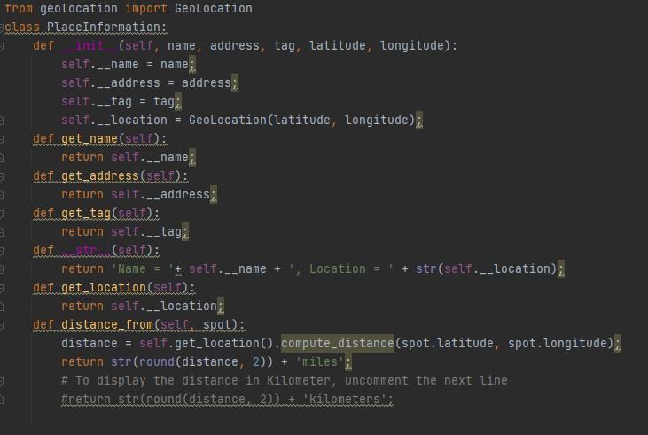
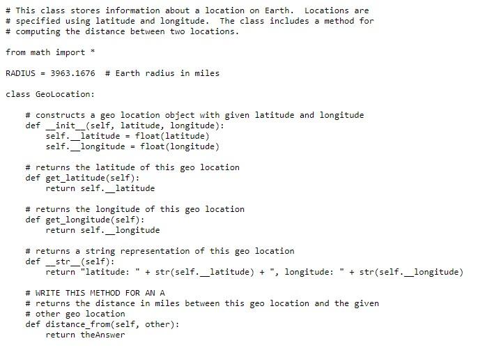
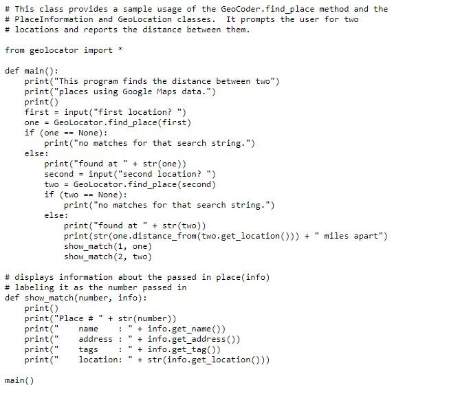
# This class stores information about a location on Earth. Locations are # specified using latitude and longitude. The class includes a method for # computing the distance between two locations. from math import * RADIUS = 3963.1676 # Earth radius in miles class GeoLocation: # constructs a geo location object with given latitude and longitude _init__(self, latitude, longitude): self._latitude - float(latitude) self._longitude float(longitude) def # returns the latitude of this geo location def get_latitude (self): return self._latitude # returns the longitude of this geo location def get_longitude (self): return self._longitude # returns a string representation of this geo location def __str_(self): return "latitude: " + str(self._latitude) + ", longitude: + str(self._longitude) # WRITE THIS METHOD FOR AN A # returns the distance in miles between this geo location and the given # other geo location def distance_from(self, other): return theAnswer # This class provides a sample usage of the Geocoder.find_place method and the # PlaceInformation and GeoLocation classes. It prompts the user for two # locations and reports the distance between them. from geolocator import def main(): print("This program finds the distance between two") print("places using Google Maps data.") print) first = input("first location? ") one = GeoLocator.find_place(first) if (one == None): print("no matches for that search string.") else: print("found at " + str(one)) second = input("second location?") two = GeoLocator.find_place (second) if (two == None): print("no matches for that search string.") else: print("found at + str(two)) print(str(one.distance_from(two.get_location())) + show_match(1, one) show_match(2, two) # displays information about the passed in place(info) # labeling it as the number passed in def show_match(number, info): print) print("Place #" + str(number)) print(" + info.get_name) print(" address: + info.get_address()) print(" tags + info.get_tag() print(" location: + str(info.get_location()) miles apart") name . . main() from geolocation import GeoLocation class PlaceInformation: def init__(self, name, address, tag, latitude, Longitude): self.__name = name;. self.__address = address; self.__tag = tagi. self.__location Geolocation (latitude, longitude) def. get.name (self): return self.__name def get_address(self): return self.__address;. def get_tag (self): return self.__tag: def stwa.(self): return 'Name = 'self.-_name + Location = + str(self.__location); E def get_location(self): return self.__location: - def distance from(self.spot): distance = self.get_location().compute_distance (spot.latitude, spot. Longitude); return str(round(distance, 2)) + miles'; # To display the distance in Kilometer, uncomment the next line #return str (round (distance 2)+kilometers # This class stores information about a location on Earth. Locations are # specified using latitude and longitude. The class includes a method for # computing the distance between two locations. from math import * RADIUS = 3963.1676 # Earth radius in miles class GeoLocation: # constructs a geo location object with given latitude and longitude _init__(self, latitude, longitude): self._latitude - float(latitude) self._longitude float(longitude) def # returns the latitude of this geo location def get_latitude (self): return self._latitude # returns the longitude of this geo location def get_longitude (self): return self._longitude # returns a string representation of this geo location def __str_(self): return "latitude: " + str(self._latitude) + ", longitude: + str(self._longitude) # WRITE THIS METHOD FOR AN A # returns the distance in miles between this geo location and the given # other geo location def distance_from(self, other): return theAnswer # This class provides a sample usage of the Geocoder.find_place method and the # PlaceInformation and GeoLocation classes. It prompts the user for two # locations and reports the distance between them. from geolocator import def main(): print("This program finds the distance between two") print("places using Google Maps data.") print) first = input("first location? ") one = GeoLocator.find_place(first) if (one == None): print("no matches for that search string.") else: print("found at " + str(one)) second = input("second location?") two = GeoLocator.find_place (second) if (two == None): print("no matches for that search string.") else: print("found at + str(two)) print(str(one.distance_from(two.get_location())) + show_match(1, one) show_match(2, two) # displays information about the passed in place(info) # labeling it as the number passed in def show_match(number, info): print) print("Place #" + str(number)) print(" + info.get_name) print(" address: + info.get_address()) print(" tags + info.get_tag() print(" location: + str(info.get_location()) miles apart") name . . main() from geolocation import GeoLocation class PlaceInformation: def init__(self, name, address, tag, latitude, Longitude): self.__name = name;. self.__address = address; self.__tag = tagi. self.__location Geolocation (latitude, longitude) def. get.name (self): return self.__name def get_address(self): return self.__address;. def get_tag (self): return self.__tag: def stwa.(self): return 'Name = 'self.-_name + Location = + str(self.__location); E def get_location(self): return self.__location: - def distance from(self.spot): distance = self.get_location().compute_distance (spot.latitude, spot. Longitude); return str(round(distance, 2)) + miles'; # To display the distance in Kilometer, uncomment the next line #return str (round (distance 2)+kilometers
Step by Step Solution
There are 3 Steps involved in it

Get step-by-step solutions from verified subject matter experts