

Question: Hi! I have a question about my remote sensing class. Can someone explain this? LILUESLION 4 b.b pts In an accuracy assessment of image classification,
Hi! I have a question about my remote sensing class. Can someone explain this?
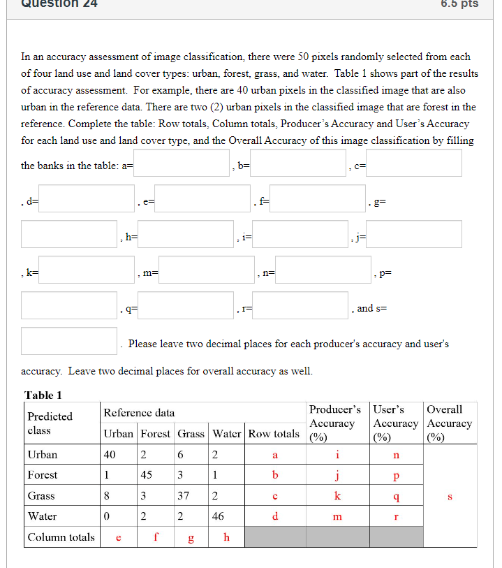
LILUESLION 4 b.b pts In an accuracy assessment of image classification, there were 30 pixels randomly selected from each of four land use and land cover types: urban, forest, grass, and water. Table 1 shows part of the results of accuracy assessment. For example, there are 40 urban pixels in the classified image that are also urban in the reference data. There are two (2) urban pixels in the classified image that are forest in the reference. Complete the table: Row totals, Column totals, Producer's Accuracy and User's Accuracy for each land use and land cover type, and the Overall Accuracy of this image classification by filling the banks in the table: a= b= = d= = = g= b= i= = k= m= n= p= - 95 . I= . and 5= . Please leave two decimal places for each producer's accuracy and user's accuracy. Leave two decimal places for overall accuracy as well. Table 1 Predicted Reference data Producer's |User's Owverall - Accuracy | Accuracy | Accuracy class Urban | Forest | Grass | Water | Row totals (%) (%) (%) oo T T8 3 o o by | Column Lolals
Step by Step Solution
There are 3 Steps involved in it

Get step-by-step solutions from verified subject matter experts