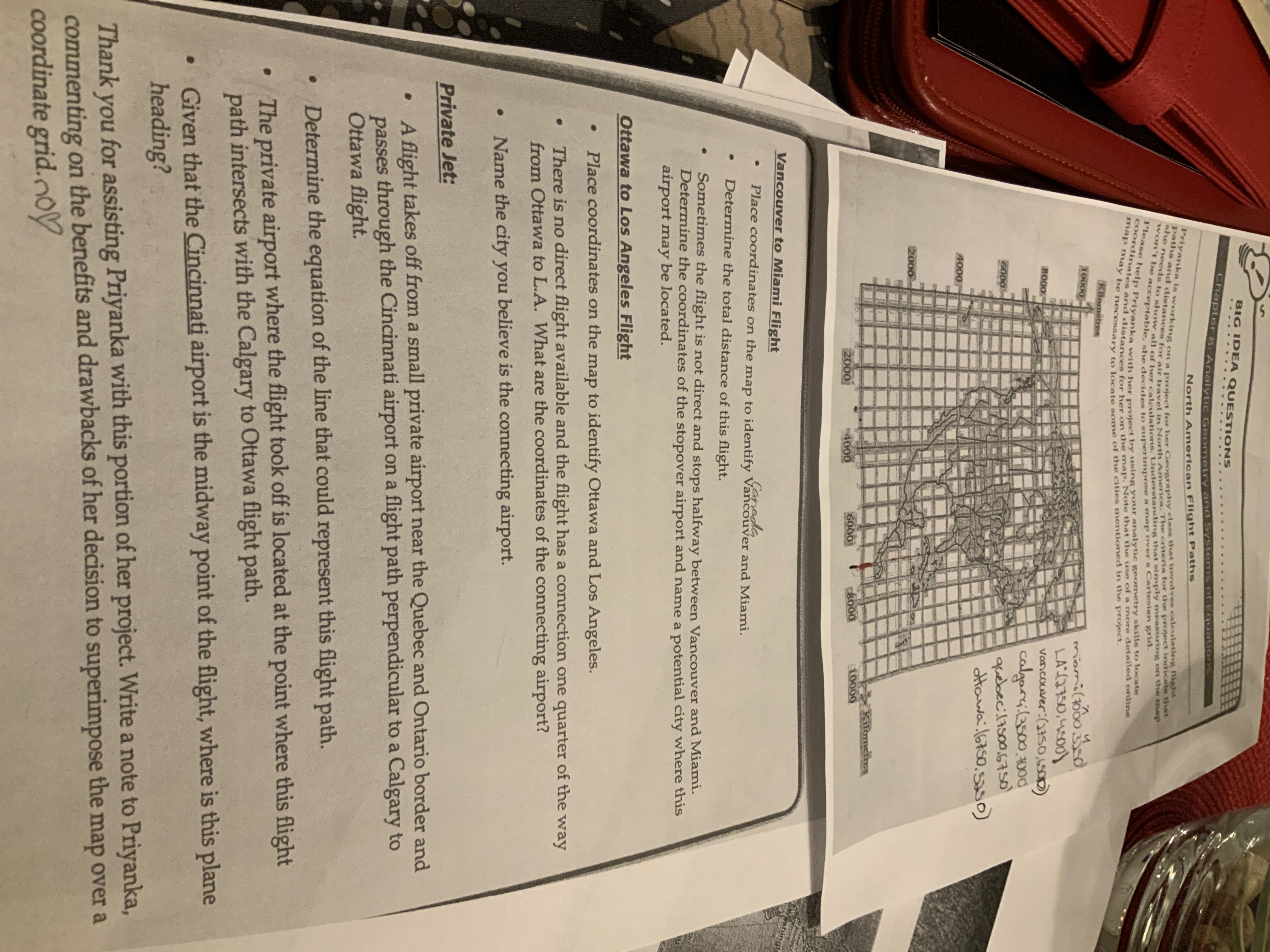
Question: How do I determine the coordinates and distance BIG IDEA QUESTIONS . . . . .. . ..... ... Analytic North American Flight Paths Paths

How do I determine the coordinates and distance

How do I determine the coordinates and distance
BIG IDEA QUESTIONS . . . . .. . ..... ... Analytic North American Flight Paths Paths tha is working on a She needs distances for a Project for her Geography class that involves calculating, flight hopes for air travel in North Americading that simply measuring o eptable, she decides to superimpose a map over a Cartesian grid,of the map rdinates anganka with her project by using your analytic geometry skills to locate for her on the map. Note that the use of a r map may be necessary to locate some of the of the cities mentioned in the projectedonline Kilometres miami (1000 3)50 LA"(2750, 4500) 8000 vancouver: (2750, 6500) calgary. (3500, 700 6090 quebec: 17500, 6750 ottawa. (6750. 5250) 4000 2000 Kilometres 2000 "4000 6000 8000 10000 Vancouver to Miami Flight Place coordinates on the map to identify Vancouver and Miami. Determine the total distance of this flight. Sometimes the flight is not direct and stops halfway between Vancouver and Miami. Determine the coordinates of the stopover airport and name a potential city where this airport may be located. Ottawa to Los Angeles Flight Place coordinates on the map to identify Ottawa and Los Angeles. There is no direct flight available and the flight has a connection one quarter of the way from Ottawa to L.A. What are the coordinates of the connecting airport? . Name the city you believe is the connecting airport. Private Jet: . A flight takes off from a small private airport near the Quebec and Ontario border and passes through the Cincinnati airport on a flight path perpendicular to a Calgary to Ottawa flight. . Determine the equation of the line that could represent this flight path. . The private airport where the flight took off is located at the point where this flight path intersects with the Calgary to Ottawa flight path. . Given that the Cincinnati airport is the midway point of the flight, where is this plane heading? Thank you for assisting Priyanka with this portion of her project. Write a note to Priyanka, commenting on the benefits and drawbacks of her decision to superimpose the map over a coordinate grid.noy

Step by Step Solution

There are 3 Steps involved in it

1 Expert Approved Answer
Step: 1 Unlock blur-text-image
Question Has Been Solved by an Expert!

Get step-by-step solutions from verified subject matter experts

Step: 2 Unlock
Step: 3 Unlock

Students Have Also Explored These Related Mathematics Questions!