

Question: how should graph look like? , im not sure how its suppose to look The distances (in miles) between the Indiana cities of Gary, Fort
how should graph look like? , im not sure how its suppose to look 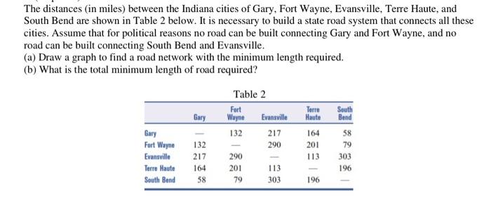
The distances (in miles) between the Indiana cities of Gary, Fort Wayne, Evansville, Terre Haute, and South Bend are shown in Table 2 below. It is necessary to build a state road system that connects all these cities. Assume that for political reasons no road can be built connecting Gary and Fort Wayne, and no road can be built connecting South Bend and Evansville. (a) Draw a graph to find a road network with the minimum length required. (b) What is the total minimum length of road required Step by Step Solution
There are 3 Steps involved in it
1 Expert Approved Answer
Step: 1 Unlock

Question Has Been Solved by an Expert!
Get step-by-step solutions from verified subject matter experts
Step: 2 Unlock
Step: 3 Unlock