

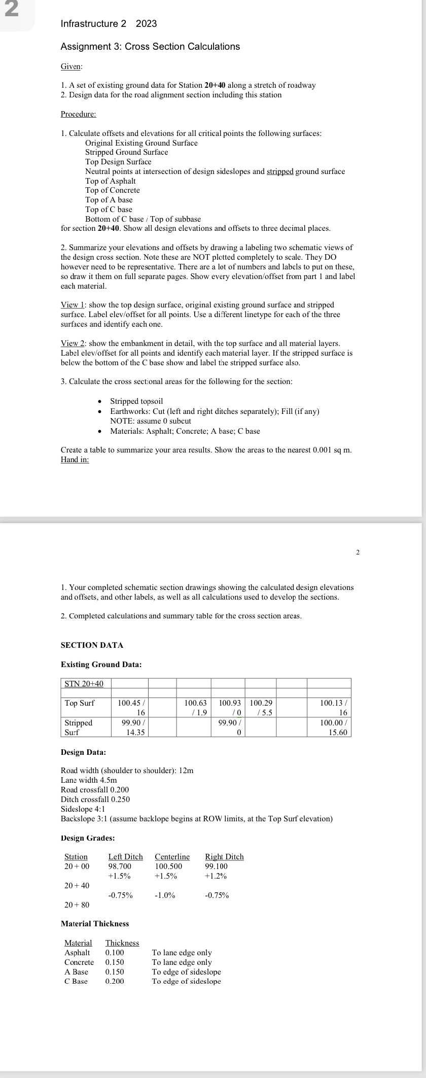
Question: Infrastructure 2 2 0 2 3 Assignment 3 : Cross Section Calculations Given: A set of existing ground data for Station 2 0 + 4
Infrastructure
Assignment : Cross Section Calculations
Given:
A set of existing ground data for Station along a stretch of roadway
Design data for the road alignment section including this station
Procedure:
Calculate offsets and elevations for all critical points the following surfaces: Original Existing Ground Surface
Stripped Ground Surface
Top Design Surface
Neutral points at intersection of design sideslopes and stripped ground surface
Top of Asphalt
Top of Concrete
Top of A base
Top of base
Bottom of base Top of subbase
for section Show all design elevations and offsets to three decimal places.
Summarize your elevations and offsets by drawing a labeling two schematic views of the design cross section. Note these are NOT plotted completely to scale. They DO however need to be representative. There are a lot of numbers and labels to put on these, so draw it them on full separate pages. Show every elevationoffset from part and label each material.
View : show the top design surface, original existing ground surface and stripped surface. Label elevoffset for all points. Use a different linetype for each of the three surfaces and identify each one.
View : show the embankment in detail, with the top surface and all material layers. Label elevoffset for all points and identify each material layer. If the stripped surface is below the bottom of the base show and label the stripped surface also.
Calculate the cross sectional areas for the following for the section:
Stripped topsoil
Earthworks: Cut left and right ditches separately; Fill if any
NOTE: assume subcut
Materials: Asphalt; Concrete; A base; base
Create a table to summarize your area results. Show the areas to the nearest Hand in:
Your completed schematic section drawings showing the calculated design elevations and offsets, and other labels, as well as all calculations used to develop the sections.
Completed calculations and summary table for the cross section areas.
Solve these for me please
Step by Step Solution
There are 3 Steps involved in it
1 Expert Approved Answer
Step: 1 Unlock

Question Has Been Solved by an Expert!
Get step-by-step solutions from verified subject matter experts
Step: 2 Unlock
Step: 3 Unlock