

Question: Intro to Total Station Coordinates for your occupied point: Procedure: Set up the total station over the occupied point. Level the instrument. Measure the height
Intro to Total Station
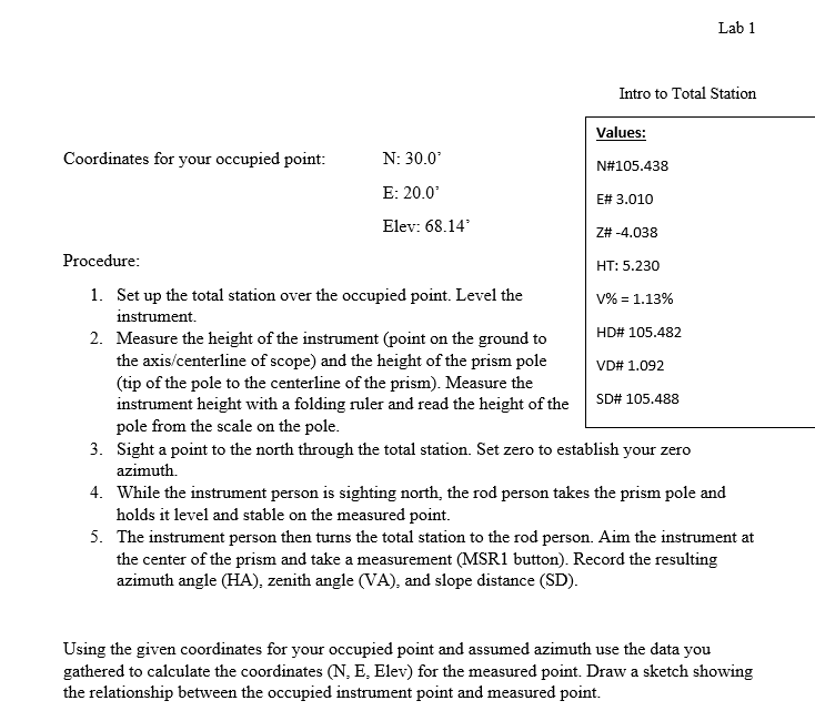
Coordinates for your occupied point:
Procedure:
Set up the total station over the occupied point. Level the
instrument.
Measure the height of the instrument point on the ground to
the axiscenterline of scope and the height of the prism pole
tip of the pole to the centerline of the prism Measure the
instrument height with a folding ruler and read the height of the
pole from the scale on the pole.
Sight a point to the north through the total station. Set zero to establish your zero
azimuth.
While the instrument person is sighting north, the rod person takes the prism pole and
holds it level and stable on the measured point.
The instrument person then turns the total station to the rod person. Aim the instrument at
the center of the prism and take a measurement MSR button Record the resulting
azimuth angle HA zenith angle VA and slope distance SD
Values:
N#
E#
Z#
HT:
HD#
VD#
SD#
:
E:
Elev:
Procedure: Set up the total station over the occupied point. Level the
Measure the height of the instrument point on the ground to the axiscenterline of scope and the height of the prism pole tip of the pole to the centerline of the prism Measure the instrument height with a folding ruler and read the height of the pole from the scale on the pole.
VD#
Step by Step Solution
There are 3 Steps involved in it
1 Expert Approved Answer
Step: 1 Unlock

Question Has Been Solved by an Expert!
Get step-by-step solutions from verified subject matter experts
Step: 2 Unlock
Step: 3 Unlock