

Question: . . . MAKE SURE TO DRAW THE CROSS - SECTIONS AS ASKED... Q ) Borehole data from a site investigation shows three layers in
MAKE SURE TO DRAW THE CROSSSECTIONS AS ASKED...
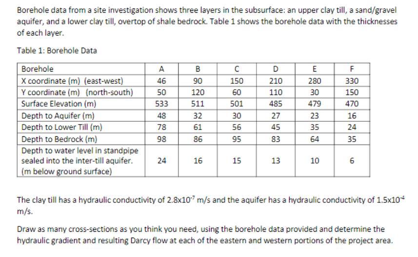
Q Borehole data from a site investigation shows three layers in the subsurface: an upper clay till, a sandgravel aquifer, and a lower clay till, overtop of shale bedrock. Table shows the borehole data with the thicknesses of each layer.
Table : Borehole Data
tableBoreholeABCDEFX coordinate meastwestY coordinate mnorthsouthSurface Elevation mDepth to Aquifer mDepth to Lower Till mDepth to Bedrock mtableDepth to water level in standpipesealed into the intertill aquifer.m below ground surface
The clay till has a hydraulic conductivity of and the aquifer has a hydraulic conductivity of
Draw as many crosssections as you think you need, using the borehole data provided and determine the hydraulic gradient and resulting Darcy flow at each of the eastern and western portions of the project area.
Step by Step Solution
There are 3 Steps involved in it
1 Expert Approved Answer
Step: 1 Unlock

Question Has Been Solved by an Expert!
Get step-by-step solutions from verified subject matter experts
Step: 2 Unlock
Step: 3 Unlock