

Question: please do this quetion as fast as possible. Triangle Average Cool Thickness Triangle Area Triangle Average Coal Thickness Triangle Area 1 2-6 23.5 3-4-5 5-73
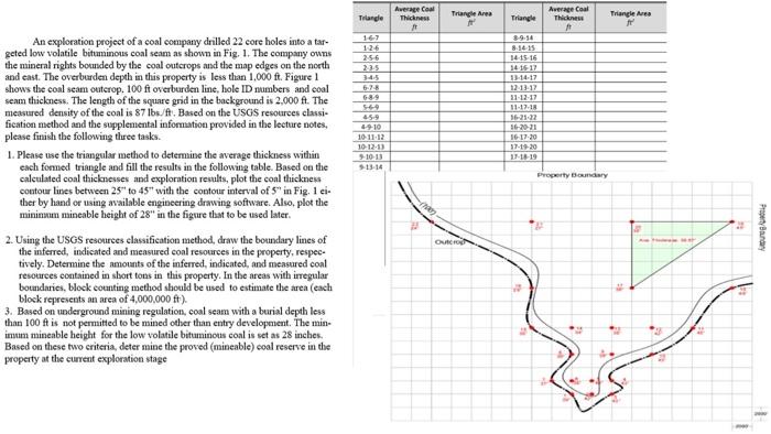
Triangle Average Cool Thickness Triangle Area Triangle Average Coal Thickness Triangle Area 1 2-6 23.5 3-4-5 5-73 An exploration project of a coal company drilled 22 core holes into a tar- geted low volatile bituminous coal seam as shown in Fig. 1. The company owns the mineral rights bounded by the coal outcrops and the map edges on the north and east. The overburden depth in this property is less than 1,000 ft. Figure 1 shows the coal scam outcrop. 100 ft overburden line, hole ID numbers and coal seam thickness. The length of the square grid in the background is 2.000 A. The measured density of the coal is 87 lbs./A. Based on the USGS resources classi- fication method and the supplemental information provided in the lecture notes, please finish the following three tasks. 1. Please use the triangular method to determine the average thickness within each fonned triangle and fill the results in the following table. Based on the calculated coal thicknesses and exploration results, plot the coal thickness contour lines between 25 to 45" with the contour interval of 5" in Fig. 1 ci- ther by hand or using available engineering drawing software. Also, plot the minimum mineable height of 28" in the figure tlust to be used later, 39:16 8.14.15 14-15-16 141617 13-14-17 12-13-12 21.12.17 11.12.18 16-21-32 16-2021 16.17.20 17:10 17 18 19 16 45.9 4910 10-11-12 10-12-13 10-13 13-14 Property Bondary Protary OUCION 2. Using the USGS resources classification method, draw the boundary lines of the inferred, indicated and measured coal resources in the property, respec- tively. Determine the amounts of the inferred, indicated, and measured coal resources contained in sbort tots in this property. In the areas with irregular boundaries, block counting method should be used to estimate the area (each block represents an area of 4,000,000 ft). 3. Based on underground mining regulation, coal seam with a burial depth less than 100 ft is not permitted to be mined other than entry development. The min imm mineable height for the low volatile bituminous coal is set as 28 inches. Based on these two criteria, determine the proved (mineable) coal reserve in the property at the current exploration stage Triangle Average Cool Thickness Triangle Area Triangle Average Coal Thickness Triangle Area 1 2-6 23.5 3-4-5 5-73 An exploration project of a coal company drilled 22 core holes into a tar- geted low volatile bituminous coal seam as shown in Fig. 1. The company owns the mineral rights bounded by the coal outcrops and the map edges on the north and east. The overburden depth in this property is less than 1,000 ft. Figure 1 shows the coal scam outcrop. 100 ft overburden line, hole ID numbers and coal seam thickness. The length of the square grid in the background is 2.000 A. The measured density of the coal is 87 lbs./A. Based on the USGS resources classi- fication method and the supplemental information provided in the lecture notes, please finish the following three tasks. 1. Please use the triangular method to determine the average thickness within each fonned triangle and fill the results in the following table. Based on the calculated coal thicknesses and exploration results, plot the coal thickness contour lines between 25 to 45" with the contour interval of 5" in Fig. 1 ci- ther by hand or using available engineering drawing software. Also, plot the minimum mineable height of 28" in the figure tlust to be used later, 39:16 8.14.15 14-15-16 141617 13-14-17 12-13-12 21.12.17 11.12.18 16-21-32 16-2021 16.17.20 17:10 17 18 19 16 45.9 4910 10-11-12 10-12-13 10-13 13-14 Property Bondary Protary OUCION 2. Using the USGS resources classification method, draw the boundary lines of the inferred, indicated and measured coal resources in the property, respec- tively. Determine the amounts of the inferred, indicated, and measured coal resources contained in sbort tots in this property. In the areas with irregular boundaries, block counting method should be used to estimate the area (each block represents an area of 4,000,000 ft). 3. Based on underground mining regulation, coal seam with a burial depth less than 100 ft is not permitted to be mined other than entry development. The min imm mineable height for the low volatile bituminous coal is set as 28 inches. Based on these two criteria, determine the proved (mineable) coal reserve in the property at the current exploration stage
Step by Step Solution
There are 3 Steps involved in it

Get step-by-step solutions from verified subject matter experts