

Question: PLEASE HELP ME DETERMINE WHERE THE BEST PLACE WOULD BE TO PLACE A PUMP IN THIS PROBLEM. PLEASE HELP ME DETERMINE THE SIZE OF THE
PLEASE HELP ME DETERMINE WHERE THE BEST PLACE WOULD BE TO PLACE A PUMP IN THIS PROBLEM. PLEASE HELP ME DETERMINE THE SIZE OF THE PIPE AND PUMP THAT WOULD BE NEEDED TO MAKE THIS POSSIBLE. AND IF POSSIBLE PLEASE HELP ME DETERMINE THE COST OF A PROJECT LIKE THIS.
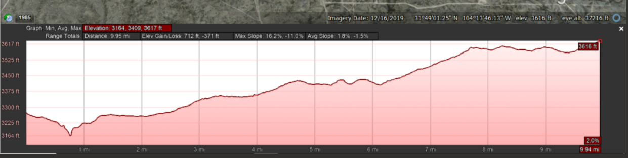
A new well with a projected flow of 25k bpd produced water is going into a gathering system that needs to travel uphill to be disposed of in a salt water disposal (SWD) well 10 miles away. The produced water will then be injected into an SWD well at the SWD facility pumping station. Along the gathering system there are two other existing wells that produce 15k bpd of produced water at mile marker 3.1 and 6.5. The scope of work is limited to selecting and sizing the optimum use of a booster pumping facility, and determining the mile marker of the booster pump location, and the sizing of and 10-mile-long pipeline. = Max CTB pressure (psia) Min SWD pressure inlet (psia) Flowing Inlet Temperature (deg F) = Salt Water Composition Elevation Profile 120 20 100 See attached See attached Imagery Date: 12/16/2019 3149'01.25"N 10413'46.13" W elev 3616 ft eye alt 37216 ft O 1985 Graph: Min. Avg. Max Elevation: 3164, 3409. 3617 ft Range TotalsDistance: 9.95 mi Elev GainLoss 712 ft. -371 ft 3617 It Max Slope 16.2%, -11.0% Avg Slope: 1.8%, -1.5% 3616 3525 ft 3450 ft 3375 it 3300 ft 3225 ft 3164 ft 2.0% 9.94 mi 1 mi 2 m 3 m 4 mi 5 mi 6m 7 mi 8 mi 9 m A new well with a projected flow of 25k bpd produced water is going into a gathering system that needs to travel uphill to be disposed of in a salt water disposal (SWD) well 10 miles away. The produced water will then be injected into an SWD well at the SWD facility pumping station. Along the gathering system there are two other existing wells that produce 15k bpd of produced water at mile marker 3.1 and 6.5. The scope of work is limited to selecting and sizing the optimum use of a booster pumping facility, and determining the mile marker of the booster pump location, and the sizing of and 10-mile-long pipeline. = Max CTB pressure (psia) Min SWD pressure inlet (psia) Flowing Inlet Temperature (deg F) = Salt Water Composition Elevation Profile 120 20 100 See attached See attached Imagery Date: 12/16/2019 3149'01.25"N 10413'46.13" W elev 3616 ft eye alt 37216 ft O 1985 Graph: Min. Avg. Max Elevation: 3164, 3409. 3617 ft Range TotalsDistance: 9.95 mi Elev GainLoss 712 ft. -371 ft 3617 It Max Slope 16.2%, -11.0% Avg Slope: 1.8%, -1.5% 3616 3525 ft 3450 ft 3375 it 3300 ft 3225 ft 3164 ft 2.0% 9.94 mi 1 mi 2 m 3 m 4 mi 5 mi 6m 7 mi 8 mi 9 m
Step by Step Solution
There are 3 Steps involved in it

Get step-by-step solutions from verified subject matter experts