

Question: Please Solve Asap. Big Jim plows snow for five residential customers in northern New Hampshire. Placing a Cartesian coordinate system on a map of his

Please Solve Asap.
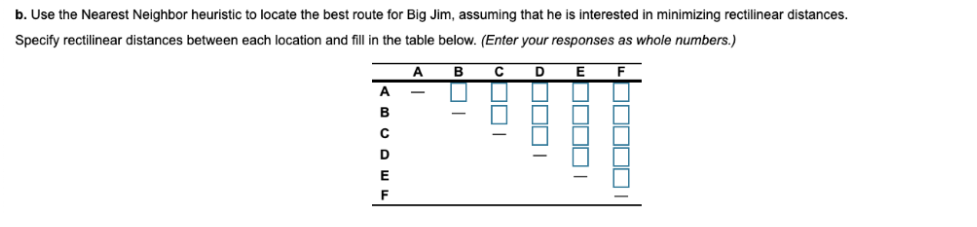
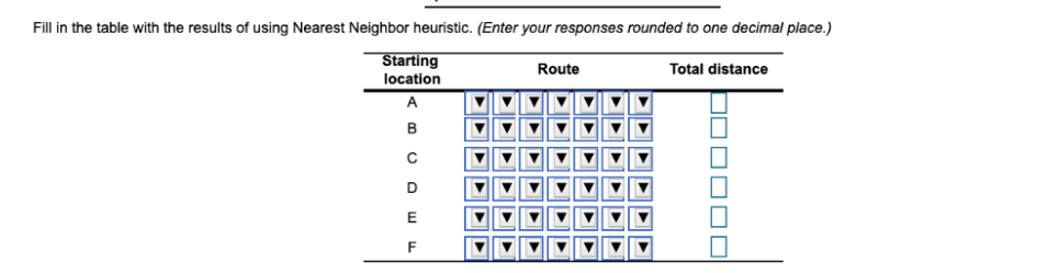
Big Jim plows snow for five residential customers in northern New Hampshire. Placing a Cartesian coordinate system on a map of his service area, with his home at the origin (A), Big Jim located his five customers at coordinates: B (20,9); C (26,31); D (15,26); E (21,47); F (12,42). He has two ways to measure distances between his customers: Euclidian and rectilinear (See Chapter 3, Process Strategy and the section on layouts for the definitions of these measures). He is wondering if his method of measuring distances will affect the sequence of customer locations he must visit to minimize his energy costs. b. Use the Nearest Neighbor heuristic to locate the best route for Big Jim, assuming that he is interested in minimizing rectilinear distances. Specify rectilinear distances between each location and fill in the table below. (Enter your responses as whole numbers.) A B D A B ODI WOOODI b0000 D E F Fill in the table with the results of using Nearest Neighbor heuristic. (Enter your responses rounded to one decimal place.) Starting Route location Total distance B D E FStep by Step Solution
There are 3 Steps involved in it
1 Expert Approved Answer
Step: 1 Unlock

Question Has Been Solved by an Expert!
Get step-by-step solutions from verified subject matter experts
Step: 2 Unlock
Step: 3 Unlock