

Question: Project Brief Table 1 : Project coordinates table [ [ Position number,Coordinates ] , [ A , 2 5 deg 4 4 ^
Project Brief Table : Project coordinates
tablePosition number,CoordinatesAdeg Sdeg EBdeg Sdeg ECdeg Sdeg EDdeg Sdeg EEdeg Sdeg EFdeg Sdeg EGdeg Sdeg EHdeg Sdeg EIdeg Sdeg EJdeg Sdeg Ebar Kdeg Sdeg ELdeg Sdeg EMdeg Sdeg ENdeg Sdeg EOdeg Sdeg EPdeg Sdeg EQdeg S deg ERdeg S deg ESdeg Sdeg E
Part A: Report written assessment component Part A: Report written assessment component
Perform a geological investigation plan desktop study for this proposed road.
Submit a report to present all your findings. The report must, at a minum, cover the
following aspects:
A signed declaration that you have performed the work on your own. A zero
mark will be awarded to all projects that do not include this signed declaration
Introduction
Site description
Climatic Weinert area and topographic data
Proposal on the field work that will need to be undertaken
Proposal on laboratory testing that will need to be undertaken
Occupational health and safety OHS: A brief description of how you will
ensure that all field and laboratory work that will be carried out will comply to
currently applicable OHS legislation. List the relevant sections of legislation.
Description of the hydrology along the alignment. Identify areas where bridges
or major culverts may be required Comprehensive identification of the geology along the alignment of the road
rock and soil types, differences in geology along the proposed alignment
zoning
Observations: Identify possible problem soils and list measures that can be
implemented in the design of the road to address the problem soils
Observations: Your expectations on the excavation conditions along the route,
the erodibility of materials, foundation conditions, groundwater and drainage
conditions
Identification of possible borrowquarry areas for sourcing road construction
materials gravels for granular pavement layers and aggregates for asphalt
production or seal construction Therefore, investigte the various landforms
along the project alignment and discuss where you would expect to find
suitable materials
Consider the vertical and horizontal alignment of the road. A low mountain
pass will need to be constructed. Recommend investigations that will need to
be undertaken for slope stability etc.
You do not need to include a detailed environmental impact assessment, but
you must consider how road construction and quarrying will impact the
environment and what impact assessments will need to be carried out by a
qualified environmental consultant. List the relevant sections of legislation.
Conclusions and recommendations
All sources must be properly referenced
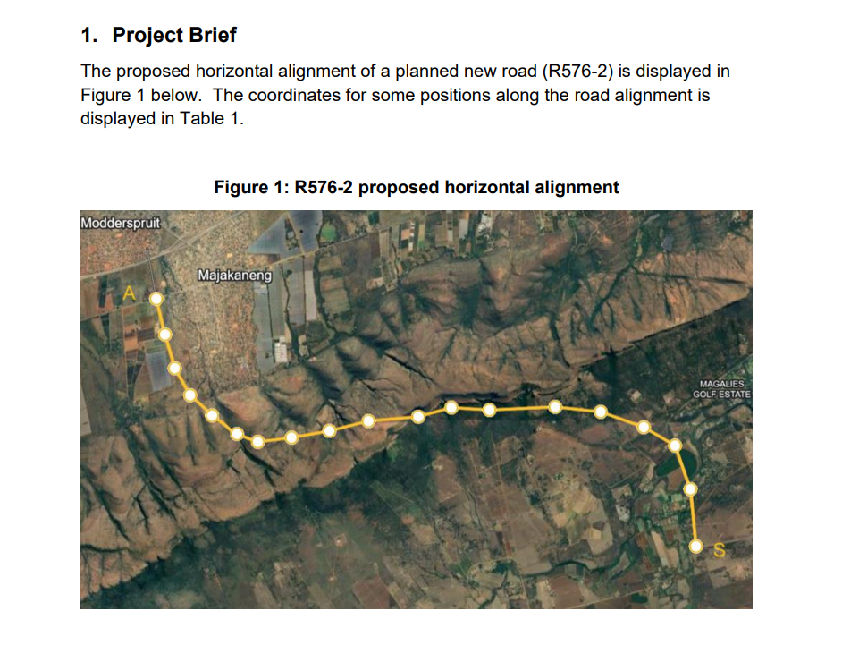
The proposed horizontal alignment of a planned new road R is displayed in
Figure below. The coordinates for some positions along the road alignment is
displayed in Table
Fiaure : R bronosed horizontal alianment
Step by Step Solution
There are 3 Steps involved in it
1 Expert Approved Answer
Step: 1 Unlock

Question Has Been Solved by an Expert!
Get step-by-step solutions from verified subject matter experts
Step: 2 Unlock
Step: 3 Unlock