

Question: recently, using a tracking microchip attached to her flipper. This allows scientists to track her movement in the ocean to see her exact location The
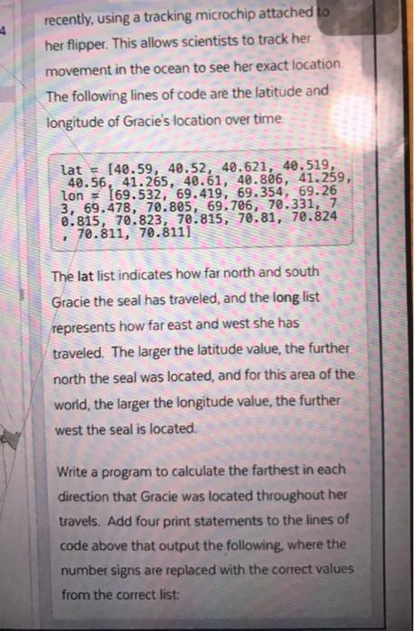
recently, using a tracking microchip attached to her flipper. This allows scientists to track her movement in the ocean to see her exact location The following lines of code are the latitude and longitude of Gracie's location over time. lat = 140.59, 40.52, 48.621, 40.519, 40.56, 41.265, 40.61, 40.866, 41.259, lon = 169.532, 69.419, 69.354, 69.26 3, 69.478, 70.805, 69, 706, 70.331, 7 0.815, 70.823, 70.815, 78.81, 70.824 70.811, 70.8111 The lat list indicates how far north and south Gracie the seal has traveled, and the long list represents how far east and west she has traveled. The larger the latitude value, the further north the seal was located, and for this area of the world, the larger the longitude value, the further west the seal is located. Write a program to calculate the farthest in each direction that Gracie was located throughout her travels. Add four print statements to the lines of code above that output the following, where the number signs are replaced with the correct values from the correct list
Step by Step Solution
There are 3 Steps involved in it

Get step-by-step solutions from verified subject matter experts