

Question: Site Mapping and GIS EVT 1 5 5 Assignment 3 Surveyor's Units & Coordinate Systems This lab involves the use of the LINE, PLINE, ARC,
Site Mapping and GIS EVT
Assignment
Surveyor's Units & Coordinate Systems
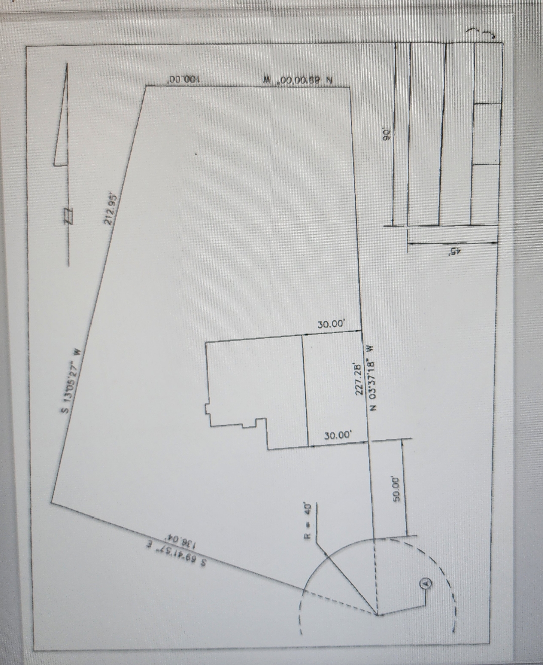
This lab involves the use of the LINE, PLINE, ARC, RECTANG, OFFSET and FILLET commends. It will also illustrate the usefulness of Surveyor's Units used in conjunction with Cartesian and Polar coordinates utilizing both absolute and relative modes of input. For this assigment you will be drawing the border, title block, boundery, building footprint, and north arrow. AutoCAD plotting will also be covered. A hard copy and a digital file will be submitted for grade.
Use the following steps to complete this project:
Start the assignment by setring the drawing units Length Type to Architectural, Precision to and Angle Type to Surveyor's Units, Precision to Nd E Set the drawing units Direction.. Base Angle to South. Set the drawing limits to lower left comer: and upper right comer.
Execute a ZOOM, ALL to force a drawing regeneration.
Begin by drawing the border. The border dimensions should equal the dimensions of the drawing limits
Nex complete the title block area. Make sure that lines meet and no overlaps occur.
Draw the boundary using the given bearing and distance information. Start the boundary at point A using coordinste values Close the boundary with an arc using the redius value as a defining parameter. Consider using the starn, end, radius option.
Draw the building footprint using the given dimensions. Start by establishing the sourheast beilding comer north and wesi of point as shown. Note: north and weat values are noe the same as and coordinates! The cass building line should be parallel to the east boundary line. Use bearings and distances to construct all building wall lines.
Draw a north arrow using a style of your choice. Make sure that it points Due Northl
Save and then plot the drawing on letter size paper using a scale of Tum in a copy of the plotted drawing AND submit a copy of the DWG file.
H
S wS SM NN O W
Step by Step Solution
There are 3 Steps involved in it
1 Expert Approved Answer
Step: 1 Unlock

Question Has Been Solved by an Expert!
Get step-by-step solutions from verified subject matter experts
Step: 2 Unlock
Step: 3 Unlock