

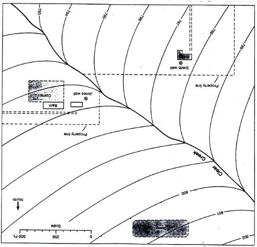
Question: The base map for HW#9 is available under files. The map shows a segment of Clear Creek with two properties, one to the north of
The base map for HW#9 is available under files. The map shows a segment of Clear Creek with two properties, one to the north of the stream (Jones property) and one to the south (Smith property). To the north of the map there is an old municipal dump. The curved lines emanating away from Clear Creek are potentiometric lines on the water table surface. Note the lines are in one-foot intervals. Draw a series of flow lines from the dump in a down-gradient direction using the two dots on the 800 contour line as a guide. Remember that the flow lines must cross the equipotential lines at right angles. Once you have the flow lines drawn answer the following questions:
Can waste emanating from the dump contaminate the Jones’ well? Why?
Can waste from the dump contaminate Clear Creek? Why?
Can waste from the dump contaminate Smith’s well? Why?
Can waste from Jones corral contaminate Jones’ well? Why? Smith’s well? Why? Clear Creek? Why?
500 FL. North LOR 009 Property line Creek wee Corrald M Souor Property ine %3D Clear -793
Step by Step Solution
3.36 Rating (143 Votes )
There are 3 Steps involved in it
To analyze groundwater flow and potential contamination follow these steps Drawing Flow Lines 1 Iden... View full answer

Get step-by-step solutions from verified subject matter experts
Document Format (2 attachments)
606ad56863816_49073.pdf
180 KBs PDF File
606ad56863816_49073.docx
120 KBs Word File