

Question: this is the map What is the representative fraction scale of this map? ( 2 pts ) If I measure 7 5 inches on this
this is the map What is the representative fraction scale of this map? pts
If I measure inches on this map, how many miles is that on actual surface of the earth? show your work
points
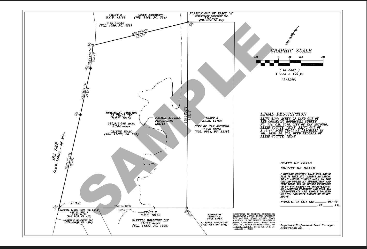
Using the metes and bounds noted on the survey, fill in the gaps for the property description below.
points
Starting at a Point Of Beginning at the Set Iron Rod IR at the southern corner of the property at the
intersection with the land of Ira Lee and Oakwell Farms,
then proceeding N feet,
then distance in ft feet,
then feet,
then N direction in DMS E feet,
then @ E feet to a post.
then feet back to the Point Of Beginning. I What do the white circles with a black outline mean? pt
II What is the scale of this survey map expressed as a representative fraction? show your work pts
Using the metes and bounds noted on the survey, fill in the gaps for the property description below
points
Hint: find the Point of Beginning POB on the map and follow traverses from there
Point of Beginning POB at Iron Pipe IP with a copper cap on the north side of State Highway at Marker
#California Division of Highways approximately miles west of the intersection with US in Santa Barbara
county, CA
Proceeding from that Point of Beginning PoB N direction in DMS W distance in ft
then S direction in DMS E to a I.POpen
then S direction in DMSdistance in ft to a I.POpen
then S E to a I.POpen
then S E to a Brass Cap,
then to a Brass Cap,
then
then S E
then.
distance back to the Point Of Beginning POB County Surveyor's Statement
This map has been examined in accordance with Section of the Professional Land
This map has been examined in accordance with Section of the Professional Surveyor's Act this th day of March,
Record of Survey
of Parcel B PM No per PM
as filed in the Office of the County Recorder,
lying in the County of Santa Barbara, State of
California
Surveyor's Statement
This map correctly represents a survey made by me or under my direction in conformance with the
requirements of the Professional Land Surveyor's Act
@
EBB Fd Brass Cap with "Survey Monument No Survey made by FF Flournoy Feb. cast on it per Rlaying horizontal
Step by Step Solution
There are 3 Steps involved in it
1 Expert Approved Answer
Step: 1 Unlock

Question Has Been Solved by an Expert!
Get step-by-step solutions from verified subject matter experts
Step: 2 Unlock
Step: 3 Unlock