

Question: This problem involves a selection of data accumulated to define the location for part of an old continental channel system within a basin. The drilling
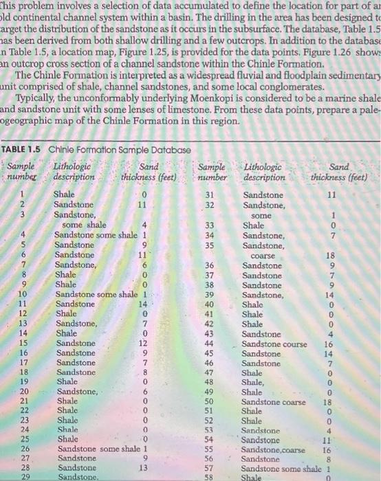
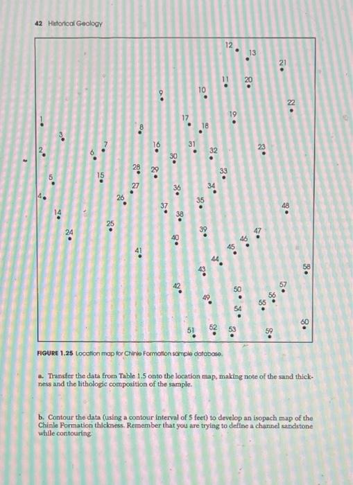
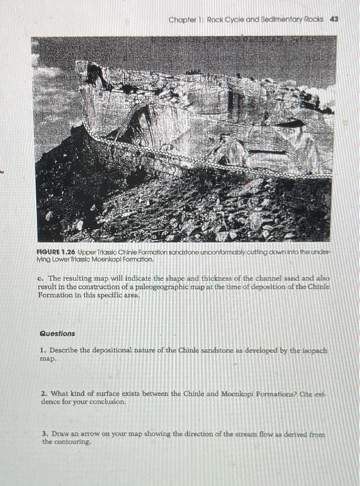
This problem involves a selection of data accumulated to define the location for part of an old continental channel system within a basin. The drilling in the area has been designed to arget the distribution of the sandstone as it occurs in the subsurface. The database, Table 1.5 has been derived from both shallow drilling and a few outcrops. In addition to the database n Table 1.5, a location map, Figure 1.25, is provided for the data points. Figure 1.26 shows an outcrop cross section of a channel sandstone within the Chinle Formation. The Chinle Formation is interpreted as a widespread fluvial and floodplain sedimentary unit comprised of shale, channel sandstones, and some local conglomerates. Typically, the unconformably underlying Moenkopi is considered to be a marine shale and sandstone unit with some lenses of limestone. From these data points, prepare a pale- ogeographic map of the Chinle Formation in this region. 34 36 9 7 38 TABLE 1.5 Chinle Formation Sample Database Sample Lithologic Sand Sample Lithologic Sand number description thickness (feet) Pumber description thickness (feet) Shale 0 31 Sandstone 11 2 Sandstone 11 32 Sandstone, 3 Sandstone, some 1 some shale 4 33 Shale 0 4 Sandstone some shale 1 Sandstone, 7 5 Sandstone 9 35 Sandstone, 6 Sandstone 11 coarse 18 7 Sandstone, 6 Sandstone 8 Shale 0 37 Sandstone 9 Shale 0 Sandstone 9 10 Sandstone some shale 1 39 Sandstone, 14 11 Sandstone 14 40 Shale 12 Shale 0 41 Shale 13 Sandstone, 7 42 Shale 14 0 43 Sandstone 4 15 Sandstone 12 44 Sandstone course 16 16 Sandstone 9 45 Sandstone 14 17 Sandstone 7 46 Sandstone 7 18 Sandstone 47 Shale 19 Shale 0 48 Shale, 20 = Sandstone, 6 49 Shale 21 Shale 0 50 Sandstone coarse 18 22 Shale 0 51 Shale 23 Shale 0 52 Shale 24 Shale 0 53 Sandstone 25 Shale 0 54 Sandstone 26 Sandstone some shale 1 55 Sandstone.coarse 27 Sandstone 9 56 Sandstone 28 Sandstone 13 57 Sandstone some shale 1 29 Sandstone Shale Shale asooOOOOO 8 00 OOO 58 0 42 Hetorical Geology 12 13 21 11 20 . 10 0. 22 . 19 18 31 O. 23 32 $9 28 33 5 15 27 26 35 37 48 14 38 24 go 49 46 45 . 8. 57 . ..8 51 52 . 53 59 FIGURE 1.25 Location map for Chinio Formation sertiple database a. Transfer the data from Table 1.5 onto the location map, making note of the sand thick ness and the lithologic composition of the sample b. Contour the data (using a contour interval of 5 feet) to develop an isopach map of the Chinle Formation thickness. Remember that you are trying to define a channel sandstone while contouring Chapter 1: Rock Cycle and Sedimentary Rocks 43 FIGURE 1.26 Upper Tronic Chinle Formation sandstone unconformably cutting down into the under Mng lower irasle Moonkopl Fonction C. The resulting map will indicate the shape and thickness of the channel sand and also result in the construction of a paloogoographic map at the time of deposition of the Chinle Formation in this specific area. Questions 1. Describe the depositional nature of the Chinle sandstone as developed by the opach map. 2. What kind of surface exists between the Chinle and Moenkop Formationa? Cite er dence for your conclusion 3. Draw an arrow on your map showing the direction of the stream flow is derived from the contouring This problem involves a selection of data accumulated to define the location for part of an old continental channel system within a basin. The drilling in the area has been designed to arget the distribution of the sandstone as it occurs in the subsurface. The database, Table 1.5 has been derived from both shallow drilling and a few outcrops. In addition to the database n Table 1.5, a location map, Figure 1.25, is provided for the data points. Figure 1.26 shows an outcrop cross section of a channel sandstone within the Chinle Formation. The Chinle Formation is interpreted as a widespread fluvial and floodplain sedimentary unit comprised of shale, channel sandstones, and some local conglomerates. Typically, the unconformably underlying Moenkopi is considered to be a marine shale and sandstone unit with some lenses of limestone. From these data points, prepare a pale- ogeographic map of the Chinle Formation in this region. 34 36 9 7 38 TABLE 1.5 Chinle Formation Sample Database Sample Lithologic Sand Sample Lithologic Sand number description thickness (feet) Pumber description thickness (feet) Shale 0 31 Sandstone 11 2 Sandstone 11 32 Sandstone, 3 Sandstone, some 1 some shale 4 33 Shale 0 4 Sandstone some shale 1 Sandstone, 7 5 Sandstone 9 35 Sandstone, 6 Sandstone 11 coarse 18 7 Sandstone, 6 Sandstone 8 Shale 0 37 Sandstone 9 Shale 0 Sandstone 9 10 Sandstone some shale 1 39 Sandstone, 14 11 Sandstone 14 40 Shale 12 Shale 0 41 Shale 13 Sandstone, 7 42 Shale 14 0 43 Sandstone 4 15 Sandstone 12 44 Sandstone course 16 16 Sandstone 9 45 Sandstone 14 17 Sandstone 7 46 Sandstone 7 18 Sandstone 47 Shale 19 Shale 0 48 Shale, 20 = Sandstone, 6 49 Shale 21 Shale 0 50 Sandstone coarse 18 22 Shale 0 51 Shale 23 Shale 0 52 Shale 24 Shale 0 53 Sandstone 25 Shale 0 54 Sandstone 26 Sandstone some shale 1 55 Sandstone.coarse 27 Sandstone 9 56 Sandstone 28 Sandstone 13 57 Sandstone some shale 1 29 Sandstone Shale Shale asooOOOOO 8 00 OOO 58 0 42 Hetorical Geology 12 13 21 11 20 . 10 0. 22 . 19 18 31 O. 23 32 $9 28 33 5 15 27 26 35 37 48 14 38 24 go 49 46 45 . 8. 57 . ..8 51 52 . 53 59 FIGURE 1.25 Location map for Chinio Formation sertiple database a. Transfer the data from Table 1.5 onto the location map, making note of the sand thick ness and the lithologic composition of the sample b. Contour the data (using a contour interval of 5 feet) to develop an isopach map of the Chinle Formation thickness. Remember that you are trying to define a channel sandstone while contouring Chapter 1: Rock Cycle and Sedimentary Rocks 43 FIGURE 1.26 Upper Tronic Chinle Formation sandstone unconformably cutting down into the under Mng lower irasle Moonkopl Fonction C. The resulting map will indicate the shape and thickness of the channel sand and also result in the construction of a paloogoographic map at the time of deposition of the Chinle Formation in this specific area. Questions 1. Describe the depositional nature of the Chinle sandstone as developed by the opach map. 2. What kind of surface exists between the Chinle and Moenkop Formationa? Cite er dence for your conclusion 3. Draw an arrow on your map showing the direction of the stream flow is derived from the contouring
Step by Step Solution
There are 3 Steps involved in it

Get step-by-step solutions from verified subject matter experts