

Question: Which method? Local Sample Mean, Inverse Distance, Inverse Squared Distance, Natural Neighbor Interpolation, Regression Model, Classification, Trend Surface Analysis, Splines, or Local Trend Surfaces? Assume
Which method?
Local Sample Mean, Inverse Distance, Inverse Squared Distance, Natural Neighbor Interpolation, Regression Model, Classification, Trend Surface Analysis, Splines, or Local Trend Surfaces?
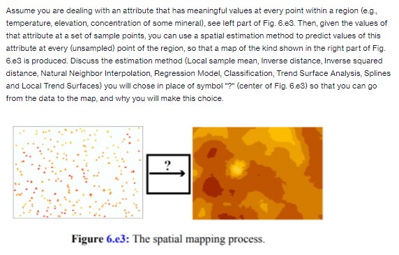
Assume you are dealing with an attribute that has meaningful values at every point within a region (e.g., temperature, elevation, concentration of some mineral), see left part of Fig. 6.e3. Then, given the values of that attribute at a set of sample points, you can use a spatial estimation method to predict values of this attribute at every (unsampled) point of the region, so that a map of the kind shown in the right part of Fig. 6.e3 is produced. Discuss the estimation method (Local sample mean, Inverse distance, Inverse squared distance, Natural Neighbor Interpolation, Regression Model, Classification, Trend Surface Analysis, Splines and Local Trend Surfaces) you will chose in place of symbol "?" (center of Fig. 6.e3) so that you can go from the data to the map, and why you will make this choice. 2 Figure 6.e3: The spatial mapping process
Step by Step Solution
There are 3 Steps involved in it

Get step-by-step solutions from verified subject matter experts