

Question: Write a method getIdentificationString() that returns a string containing the programming assignment and your name. DO NOT call this method. Just make sure it is
 Write a method getIdentificationString() that returns a string containing the programming assignment and your name. DO NOT call this method. Just make sure it is there and working correctly. The automatic grader will verify it. Write a method called printArrays (Double []
 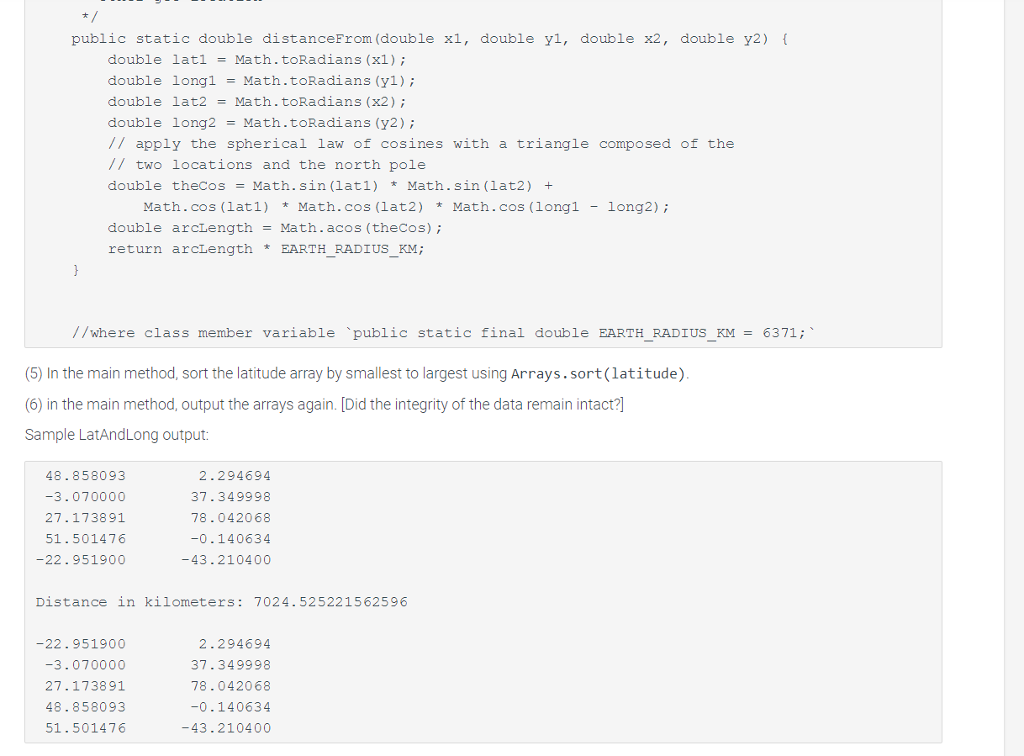 arrayl, Double [] array2) that prints the array values using this format: In the main method, create two one dimensional Double arrays (note the capital D for the wrapper class) called latitude and longitude with the following values in the order given: Latitude: 48.858093, - 3.070000, 27.173891, 51.501476, - 22.9519 Longitude: 2.294694, 37.349998, 78.042068, - 0.140634, - 43.2104 In the main method, call printArrays () to print out latitude and longitude in table form. In the main method, call distanceFrom() to find the distance between the second and fourth coordinate pairs using the Law of Cosines and print it out following "Distance in kilometers: " A coordinate pair is a latitude and longitude at a corresponding index, e.g. latitude [0] and longitude [0].
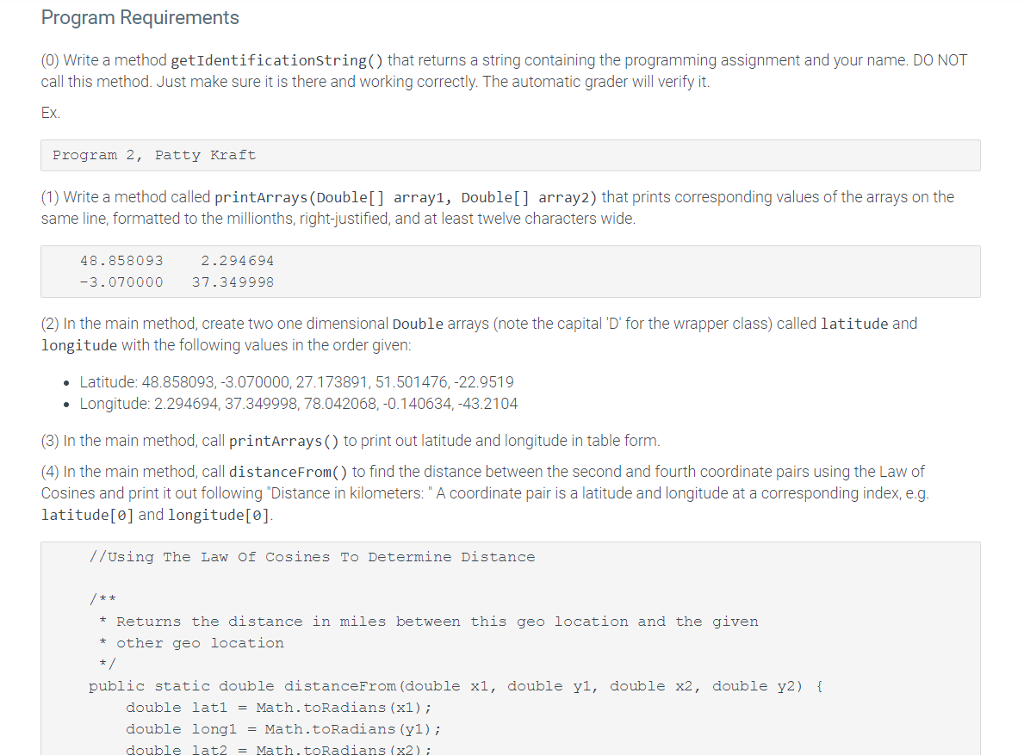
Program Requirements (0) Write a method getIdentificationstring() that returns a string containing the programming assignment and your name. DO NOT call this method. Just make sure it is there and working correctly. The automatic grader will verify it Ex. Program 2, Patty Kraft (1) Write a method called printArrays(Double[] arrayl, Double[] array2) that prints corresponding values of the arrays on the same line, formatted to the millionths, right-justified, and at least twelve characters wide. 48.858093 2.294694 -3.070000 37.349998 (2) In the main method, create two one dimensional Double arrays (note the capital 'D' for the wrapper class) called latitude and longitude with the following values in the order given Latitude: 48.858093,-3.070000,27.173891,51.501476,-22.9519 Longitude: 2.294694, 37.349998, 78.042068,-0.140634,-43.2104 (3) In the main method, call printArrays() to print out latitude and longitude in table form. (4) In the main method, call distanceFrom() to find the distance between the second and fourth coordinate pairs using the Law of Cosines and print it out following Distance in kilometers: A coordinate pair is a latitude and longitude at a corresponding index,e.g latitude and longitude //Using The Law of cosines To Determine Distance * Returns the distance in miles between this ge|ocation and the given other geo location public static double distanceFrom (double x1, double yl, double x2, double y2) double lat1 = Math. toRadians (x1); double longi -Math.toRadians (yl) double lat2 Math.toRadians (x2)
Step by Step Solution
There are 3 Steps involved in it

Get step-by-step solutions from verified subject matter experts