

Evaluate the HDI for the Gavkhooni/Zayandeh-rud basin in central Iran. This basin has five subbasins with a
Question:
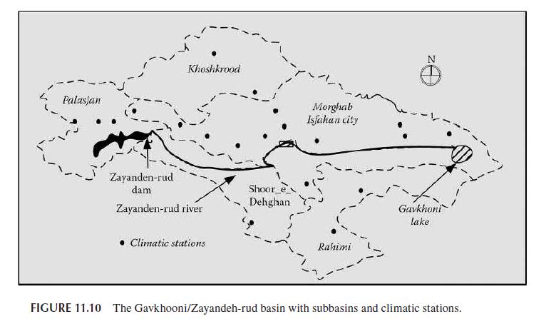
Evaluate the HDI for the Gavkhooni/Zayandeh-rud basin in central Iran. This basin has five subbasins with a total area of 41,347 km2. The dominant climate in this region is arid and semiarid. The precipitation varies throughout the basin between 2,300 mm in the west (where most of the precipitation is in snow form) and 130 mm in the central part of Iran (where Isfahan City is located).
Annual average precipitation in this basin is about 1,500 mm. The average of precipitation in the Zayandeh-rud basin has been used for the calculation of drought indices. The Zayandeh-rud River is the main surface resource for supplying the irrigation demands in this basin. As water and energy demands increase in Isfahan, water withdrawals from the river increase and it is important to incorporate climate variability into water resources’ decision-making.
The Zayandeh-rud reservoir controls the stream flow with a volume of 1,470 MCM. The location of the Zayandeh-rud reservoir is shown in Figure 11.10 . The average annual inflow to the Zayandeh-rud reservoir is about 1,600 MCM, of which an average flow of 600 MCM is transferred from the adjacent Karoon river basin. Drought trends in the basin have been studied between years 1971 and 2004.
The Gavkhooni/Zayandeh-rud basin has special effects on the development and economy of the region through agricultural, industrial, and tourism activities. Statistics show that the amount of precipitation, especially in the high altitudes from October 1999 to April 2000, has decreased
~35%–45% compared to the long-term average and resulted in 250 MCM (million cubic meters)
water shortages in the Isfahan region in the year 2000 (Karamouz et al., 2009).
Step by Step Answer:
As the first step in the HDI calculations the monthly time series of SPI modified SWSI and PDSI are calculated from 1971 to 2004 The time series of damage is converted to year 2006 values for comparis...View the full answer


Water Systems Analysis Design, And Planning Urban Infrastructure
ISBN: 9780367528454
1st Edition
Authors: Mohammad Karamouz
