

Question: Shown is a topographic map of Blue River Pine Provincial Park in British Columbia. Draw curves of steepest descent from point A (descending to Mud
Shown is a topographic map of Blue River Pine Provincial Park in British Columbia. Draw curves of steepest descent from point A (descending to Mud Lake) and from point B.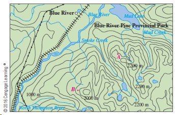
Blue Rivero Blue iver Mud Blue River Pine Provincial Park Mud Creek Safoke Creek 220 m 1000 m 3000 im/ 2200 m Noni Phonykon kiger 2016 Cengage Learning
Step by Step Solution
★★★★★
3.37 Rating (156 Votes )
There are 3 Steps involved in it
1 Expert Approved Answer
Step: 1 Unlock

The curves of steepest ascent or descent are perpendicular to all of the con... View full answer
Question Has Been Solved by an Expert!
Get step-by-step solutions from verified subject matter experts
Step: 2 Unlock
Step: 3 Unlock