

1. Meteorologists sometimes assess the stability of the lower troposphere (and thus the potential for thunderstorm development)...
Question:
1. Meteorologists sometimes assess the stability of the lower troposphere (and thus the potential for thunderstorm development) by calculating simple indices that are based on the temperature and the amount of moisture at various levels in the atmosphere. One such stability index is the Total Totals Index(or TTI), which is computed as follows:
Total Totals Index = T850 + Td850 ? (2 ? T500)
Where:
T850 is the 850-mb air temperature,
Td850 is the 850-mb dew point, and
T500 is the 500-mb air temperature.
(all temperatures are in ?C).
Note how warm, moist air at low levels increases the value of the index (low levels are represented by the 850-mb level). Also note that the colder the air at middle levels of the troposphere (midlevels are represented by the 500-mb level in the equation), the larger the value of the index. The effect of cold air at middle levels on the Total Totals Index can be seen by realizing that 500-mb temperatures are typically below zero on the Celsius scale; thus, T500 is usually negative, and subtracting a negative number creates a positive number, increasing the index. Thus, the Total Totals Index is large when warm, moist, low-level air underlies cold air at midlevels. East of the Rocky Mountains, the value of the Total Totals Index can be interpreted in Table 10.1 below:
Table 10.1
Total Totals Index Thunderstorm Outlook
44?45 Isolated or few thunderstorms
46?47 Scattered thunderstorms
48?49 Scattered thunderstorms, isolated severe thunderstorms
50?51 Scattered thunderstorms, few severe thunderstorms, isolated tornadoes
52?55 Scattered to numerous thunderstorms, few to scattered severe thunderstorms, few tornadoes
> 56 Numerous thunderstorms, scattered severe thunderstorms, scattered tornadoes
Consider the following temperature data (in ?C) observed on different days during the summer of 1995.
| 850-mb Temperature (?C) | 850-mb Dew Point (?C) | 500-mb Temperature (?C) | |
| Greensboro, North Carolina | 12 | 11 | -5 |
| Little Rock, Arkansas | 21 | 16 | -5 |
| West Palm Beach, Florida | 19 | 18 | -4 |
| Peoria, Illinois | 20 | 15 | -9 |
Calculate the Total Totals Indexes for each city, and verify that the thunderstorm outlooks for each are:
Greensboro: Thunderstorms unlikely
Little Rock: Scattered thunderstorms
West Palm Beach: Isolated or few thunderstorms
Peoria: Scattered to numerous thunderstorms, few to scattered severe thunderstorms, few tornadoes
Show your work. Remember to follow the rules of algebra in your calculations -- always multiply & divide before adding and subtracting unless parentheses indicate otherwise.
TTI Data from:
A World of Weather: Fundamentals of Meteorology . Lee M. Grenci & Jon M. Nese. Kendall/Hunt Publishing.
2. Now that the Total Totals Index was introduced to you in Activity #1, and you?ve been able to do a check on its use and calculation from given data, choose a city near a low-pressure center, near a weather front, or one that is experiencing significant precipitation or under heavy cloudiness.
Calculate the Total Totals Index for that city.
Determine the thunderstorm outlook for your chosen city.
Include a copy of all weather products you used in your work. That includes any
surface weather maps, upper air weather maps, Stuve Diagrams, or radar precipitation maps.
Be sure to show your calculations.
(For the purposes of this exercise, whether you choose a city east or west of the Rockies, you may use the same table in Activity #1 to determine the thunderstorm outlook).
3. On the surface weather map, Figure 10.1, below, clearly indicate the location of Larko?s Triangle by shading in the appropriate region.
Figure 10.1
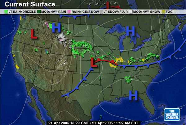
Surface Weather Map from:
The Weather Channel ? weather.com
http://www.weather.com/
Expert Answer:
1 Total Totals Index T 850 T d850 2 T 500 TTI for the following cities Greensboro ... View the full answer


The Economics of Money Banking and Financial Markets
ISBN: 978-0133836790
11th edition
Authors: Frederic S. Mishkin
