

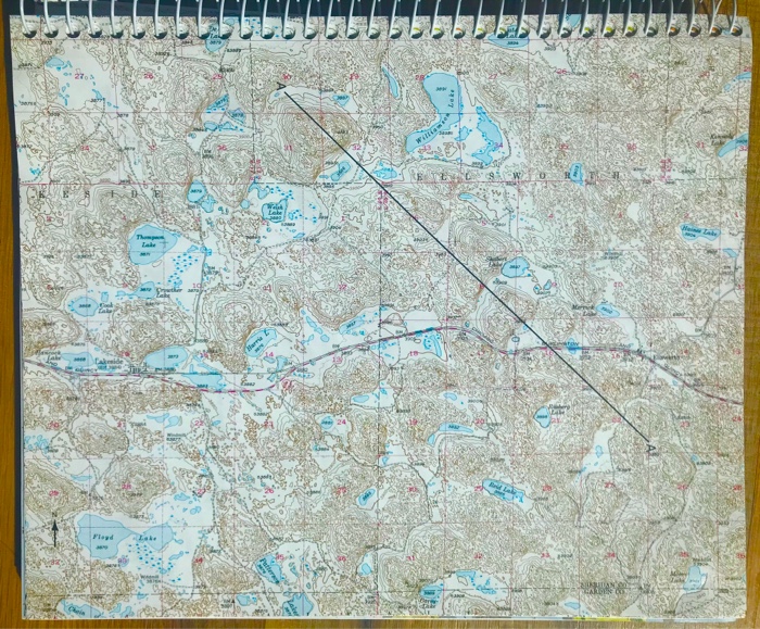
Question: a) Draw a contour map of the water table using the lake elevations in the same way you used spot elevations to make a topographic
a) Draw a contour map of the water table using the lake elevations in the same way you used spot elevations to make a topographic map. Use a contour interval of 5 feet and start with the east side of the map by drawing the 3900-foot contour.
b) In what direction does the water table slope, and what is the average gradient in feet per mile?
c) Assuming the gradient just determined is the hydraulic gradient for groundwater entering the system at Ellsworth and discharging near Lakeside, calculate the velocity, in cm/sec, at which it would flow between these points. Assume a hydraulic conductivity, K, of 1x10⁻² cm/sec and an effective porosity, P, of 20%. First convert your hydraulic gradient from units of feet/mile to feet/foot; ones this is done, the hydraulic gradient will be a unitless number.
d) If the distance between Ellsworth and Lakeside is 7 miles (11.3 km=1.13x106 cm), how long would it take for the groundwater to make this journey?
e) Note the windmill in the SW1/4, Sec.22, T24N, R44W (southeast of Lakeside) and its map symbol; the surface elevation is also given. Many other windmills are show on the map by symbol only. The windmills are connected to water wells and used to pump groundwater to fill water tanks for cattle.
f) Locate the windmill in the NW1/4, Sec.19, T24N, R43W Ho high must the water be raised by the pump to fill the stock tank? Explain your answer.
Figure 9.9 (map) is part of the Lakeside, Nebraska, quadrangle, and is part of the Sand Hills area of western Nebraska, an area composed of old sand dunes that now are mostly stabilized by vegetation. The dunes themselves have irregular surfaces with many small depressions. This makes for a complex, ?busy? contour pattern. Some of the low areas between the dunes contain small lakes. Because the sand is so permeable, these lakes form where the water table intersects the surface, and their elevation, printed on most lakes, is that of the water table.
Floyd Thomp Lake Lake CA Williamso Not TE W 0 Jaka Scale 1:62,500 C.I. 20 feet FIGURE 9.9 (Page 175) Portion of Lakeside, Nebraska, 15-minute quadrangle, for Problem 1. 2 Miles 3 Kilometers
Step by Step Solution
3.40 Rating (178 Votes )
There are 3 Steps involved in it
Solution A Map Setup Write the value of each water elevation next to the respective measurement location typically at a well on the scaled map Draw th... View full answer

Get step-by-step solutions from verified subject matter experts