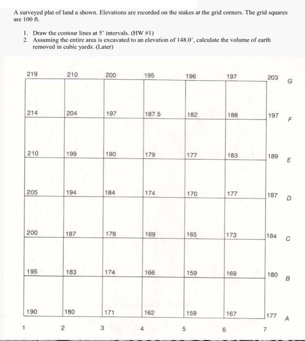
A surveyed plat of land a shown. Elevations are recorded on the stakes at the grid...
Fantastic news! We've Found the answer you've been seeking!
Question:
Transcribed Image Text:
A surveyed plat of land a shown. Elevations are recorded on the stakes at the grid corners. The grid squares are 100 ft. 1. Draw the contour lines at 5' intervals. (HW #1) 2. Assuming the entire area is excavated to an elevation of 148.0", calculate the volume of earth removed in cubic yards. (Later) 219 214 210 205 200 195 190 210 2 204 199 194 187 183 180 200 197 190 3 184 178 174 171 195 187.5 179 174 169 166 162 196 182 5 177 170 165 159 159 197 6 188 183 177 173 169 167 203 197 189 187 180 7 E 184 с D B 177 A Project Presentation 1. Inside a rectangular area that is 140 feet in the N-S direction, and 300 feet in the E-W direction, draw a contour map using a scale 1"-20' and contour interval of 1 feet. 2. Survey Data: Traverse: Start station A 68'east and 66° south of the north-west corner and follow the courses below to plot the traverse station locations. Course LAT DEP -32 +161 -18 -99 +50 -62 AB BC CA Side shots: the survey information from each station: Station A Elevation 75.0 PT AZM DIST 1 319 82 08 56 23456 45 90 2345 87 66 72 246 280 67 ELEV. 81.8 77.0 73.4 71.3 Station C Elevation 69.5 PT AZM DIST ELEV. 1 293 32 137 252 264 52 29 31 61 76.1 78.3 72.8 69.3 66.7 71.5 119 73.6 Station B Elevation 71.8 PT AZM DIST 1 328 115 2 316 84 3 295 57 226 60 04 94 36 117 22 31 4 5 6 7 8 9 67 69 93 63 77 41 10 121 11 160 ELEV. 71.4 69.2 67.3 61.7 76.6 80.6 73.0 75.8 73.6 71.8 69.5 NOTES C.L. Stream C.L. Stream C.L. Stream C.L. Stream Arca surveyed from station A Property line 341 HIGHWAY EARTHWORK Stream Control Traverse 1. The area is divided into a certain number of areas that can be seen from each station. Obstructions or terrain may prevent you from collecting all the data you need from one instrument setup point. 2. These stations form a control traverse that is measured for its angle and distances. 3. At each station key points needed for drawing a contour map are measured for azimuth, distance and elevation 4. These points are placed onto a scaled map. 5. Polygons of 3 or 5 sides are created. 6. Elevations are interpolated along these lines. 7. The contour map is drawn. Station C, Elevation = 53.0 PT AZM DIST ELEV 1 310 100 2 28 210 3 101 230 165 320 252 300 45 48.5 51.6 62.7 56.7 49.6 A surveyed plat of land a shown. Elevations are recorded on the stakes at the grid corners. The grid squares are 100 ft. 1. Draw the contour lines at 5' intervals. (HW #1) 2. Assuming the entire area is excavated to an elevation of 148.0", calculate the volume of earth removed in cubic yards. (Later) 219 214 210 205 200 195 190 210 2 204 199 194 187 183 180 200 197 190 3 184 178 174 171 195 187.5 179 174 169 166 162 196 182 5 177 170 165 159 159 197 6 188 183 177 173 169 167 203 197 189 187 180 7 E 184 с D B 177 A Project Presentation 1. Inside a rectangular area that is 140 feet in the N-S direction, and 300 feet in the E-W direction, draw a contour map using a scale 1"-20' and contour interval of 1 feet. 2. Survey Data: Traverse: Start station A 68'east and 66° south of the north-west corner and follow the courses below to plot the traverse station locations. Course LAT DEP -32 +161 -18 -99 +50 -62 AB BC CA Side shots: the survey information from each station: Station A Elevation 75.0 PT AZM DIST 1 319 82 08 56 23456 45 90 2345 87 66 72 246 280 67 ELEV. 81.8 77.0 73.4 71.3 Station C Elevation 69.5 PT AZM DIST ELEV. 1 293 32 137 252 264 52 29 31 61 76.1 78.3 72.8 69.3 66.7 71.5 119 73.6 Station B Elevation 71.8 PT AZM DIST 1 328 115 2 316 84 3 295 57 226 60 04 94 36 117 22 31 4 5 6 7 8 9 67 69 93 63 77 41 10 121 11 160 ELEV. 71.4 69.2 67.3 61.7 76.6 80.6 73.0 75.8 73.6 71.8 69.5 NOTES C.L. Stream C.L. Stream C.L. Stream C.L. Stream Arca surveyed from station A Property line 341 HIGHWAY EARTHWORK Stream Control Traverse 1. The area is divided into a certain number of areas that can be seen from each station. Obstructions or terrain may prevent you from collecting all the data you need from one instrument setup point. 2. These stations form a control traverse that is measured for its angle and distances. 3. At each station key points needed for drawing a contour map are measured for azimuth, distance and elevation 4. These points are placed onto a scaled map. 5. Polygons of 3 or 5 sides are created. 6. Elevations are interpolated along these lines. 7. The contour map is drawn. Station C, Elevation = 53.0 PT AZM DIST ELEV 1 310 100 2 28 210 3 101 230 165 320 252 300 45 48.5 51.6 62.7 56.7 49.6
Expert Answer:
Answer rating: 100% (QA)
Contour Map The contour lines are drawn at 1foot intervals with the elevations provided at each stak... View the full answer
Related Book For
Systems Analysis And Design
ISBN: 9781118897843
6th Edition
Authors: Alan Dennis, Barbara Haley Wixom, Roberta M. Roth
Posted Date:
Students also viewed these accounting questions
-
J. Fairweather is the managing director of a security company in Jamaica. As part of his management duties, he monitors the news to assess the impact of environmental changes on his operations. His...
-
A cantilever beam is subjected to load P at mid-span and counterclockwise moment M at B (see figure). (a) Find an expression for moment M in terms of the load P so that the reaction moment MA at A is...
-
Goddard Company has used the FIFO method of inventory valuation since it began operations in 2015. Goddard decided to change to the average cost method for determining inventory costs at the...
-
Distinguish between a rad and a rem?
-
2degrees is New Zealands fastest growing mobile telecommunications company - In less than 3 years, they have transformed the landscape of New Zealands mobile telecommunications market. Entering very...
-
Slip for a reciprocating pump is defined as (a) Qa-2th 2th 2th -Qa 2th -Qa Qa-2th (b) (c) (d) Qa 2th Qa
-
Because of high tuition costs at state and private universities, enrollments at community colleges have increased dramatically in recent years. The following data show the enrollment (in thousands)...
-
7. Answer for the following reaction CH3ONa a) Is this reaction SN/E1 or SN/E2 Br (2 points) b) For the reaction draw a mechanism for the substitution product and the elimination product. (4 points)...
-
A probability plot of 66 yr of peak discharges for the Kentucky River near Salvisa, Kentucky, is shown in Fig. P3-19 (a) What probability distribution is being used? (b) What are the mean and...
-
What is a scenario of a family-systems problem, wherein a school-age child is the identified patient. Discuss the family problems that exist and share the way in which a child can shield family...
-
Formula: Divide; Cell Referencing Using Excel To Compute Predetermined Overhead Rates PROBLEM Marquis Company estimated annual operating activity bases are direct labor, direct labor hours, and...
-
A person weighs902 N (203 lbs ) Whatis their mass in kg ? (Assume they are onEarth's surface) kg The same person displaces 0.0896 cubicmeters (c^3) of water volume when fullysubmerged. What is the...
-
H is awarded an all-expense paid vacation to Hawaii worth $5,000 in recognition for his outstanding service in educating members of the profession, from the professional organization known as the...
-
What is a hybrid social venture and how is it different from a purely philanthropic one? 2. Identify the differences between commercial and social entrepreneurship. Are these differences compelling...
-
A common unit for speed used in sailing is the knot (nauticalmiles per hour). A nautical mile is about 1.15 regularmiles. Calculate how much further (in feet) a boat moving at24 knots will travel in...
-
The December 31, 2007, balance sheet of Annas Tennis Shop, Inc., showed current assets of $840 and current liabilities of $320. The December 31, 2008, balance sheet showed current assets of $910 and...
-
A spacecraft has left the earth and is moving toward Mars. An observer on the earth finds that, relative to measurements made when the spacecraft was at rest, its a. length is shorter b. KE is less...
-
John is a systems analyst on the Holiday Travel Vehicle project team (see minicase 4, this chapter). The team is currently developing the systems user interface design. John has been given the task...
-
Frank, the IS department manager at the Kelso Company was brought in to the firm with a mandate to get the IS department shaped up. Kelso management was dissatisfied with a number of aspects of the...
-
In the new system for Jones Legal Investigation Services, a client-attorney provides information about a case and requests that a case-investigation be conducted. The cases that this firm specializes...
-
Using a search engine such as Google, search for power of a hypothesis test. Describe what the power of a hypothesis test is.
-
H 0 : The lottery is fair. Ha: The lottery is biased. Without using the terms null hypothesis and alternative hypothesis, identify the type I error and identify the type II error.
-
What do p, p, and P-value represent?
Study smarter with the SolutionInn App