

Question: Assignment 5. Drawing Data /15 1. Please convert the following raster data structures back to the correct image that would be displayed on a computer
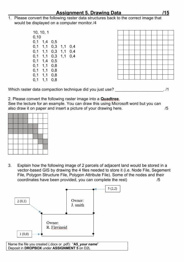
Assignment 5. Drawing Data /15 1. Please convert the following raster data structures back to the correct image that would be displayed on a computer monitor.14 10, 10, 1 0,10 0,1 1,4 0,5 0,1 1,1 0,3 1,1 0,4 0.1 1.1 0.3 1.1 0.4 0,1 1,1 0,3 1,1 0,4 0,1 1,4 0,5 0,1 1,1 0,8 0,1 1,1 0,8 0.1 1.1 0,8 0,1 1,1 0,8 /1 Which raster data compaction technique did you just use? 2. Please convert the following raster image into a Quadtree, See the lecture for an example. You can draw this using Microsoft word but you can also draw it on paper and insert a picture of your drawing here. /5 3. Explain how the following image of 2 parcels of adjacent land would be stored in a vector-based GIS by drawing the 4 files needed to store it (.e. Node File, Segement File, Polygon Structure File, Polygon Attribute File). Some of the nodes and their coordinates have been provided, you can complete the rest) 15 5 (2.2) 2 (0,1) Owner: J. Smith Owner: R. Flavinoid 1 (0,0) Name the file you created (.docx or .pdf): "A5_your name Deposit in DROPBOX under ASSIGNMENT 5 on D2L
Step by Step Solution
There are 3 Steps involved in it

Get step-by-step solutions from verified subject matter experts