

Question: first picture is needed to complete second chart Mean Included Angle Facel Swing Mean Decimal (deal Instrument Station Fore Station Included Angle Decimal (degl Back
first picture is needed to complete second chart 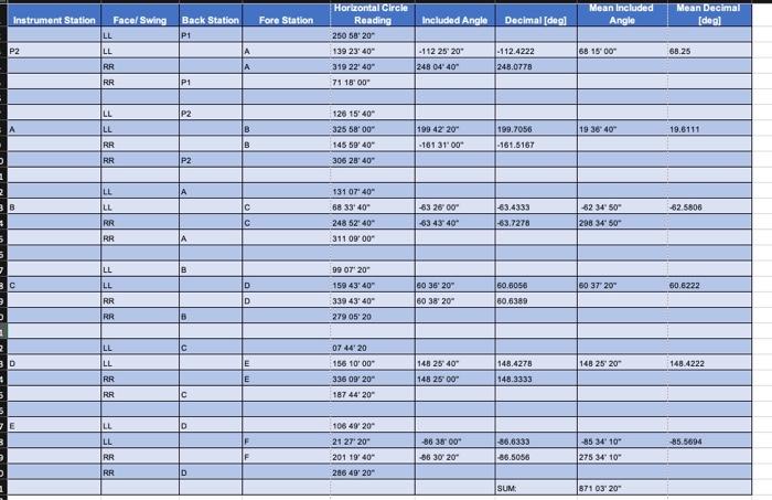
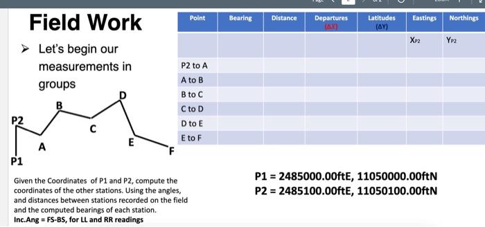
Mean Included Angle Facel Swing Mean Decimal (deal Instrument Station Fore Station Included Angle Decimal (degl Back Station P1 Horizontal Circle Reading 250 5820 139 23' 40" P2 58 15 00 68.25 - 112 25 20- 248 04' 40" - 112.4222 248.0778 A 319 22 40" P1 75 18'00" P2 126 15' 404 199 42 20" 19 3640" 19.5111 325 58'00" 145 5940 306 23' 40 199.7056 - 161.8167 B -161 31'00" P2 | B 53 26 00 -62 3450" 62.5806 131 07' 40" 68 3340 248 5240- 311 09:00 -63.4333 -63.7278 C 63 43' 40" 298 349 50 = = = = = = F F = = F F = = = = = = = = = = F F| B C 99 07 20 159 43' 40" 339 43' 40" 60 37" 20" 60.6222 60 36" 20" 60 38' 20" 60.6056 60,6389 D 6 2790520 C 07 44 20 156 10'00" D E 148 25 40 148 25' 20 148.4222 148.4278 148.3333 E 148 25 00 336 09' 20" 187 44' 20" c D 85.5694 106 49 20 21 27 20" 201 1940 286 49' 20" -86 3800" 36 30 20 -86.6333 86.5056 -85 34' 10" 275 34' 10" D SUM 871 03" 20" Point Bearing Distance Departures AN Latitudes (AY) Eastings Northings Xp2 YP2 Field Work Let's begin our measurements in groups B P2 A P1 P2 to A A to B to c Cto D Dto E E to F E F P1 = 2485000.00ft, 11050000.00ftN P2 = 2485100.00ft, 11050100.00ftN Given the Coordinates of P1 and P2, compute the coordinates of the other stations. Using the angles, and distances between stations recorded on the field and the computed bearings of each station. Inc.Ang = FS-BS, for LL and RR readings Mean Included Angle Facel Swing Mean Decimal (deal Instrument Station Fore Station Included Angle Decimal (degl Back Station P1 Horizontal Circle Reading 250 5820 139 23' 40" P2 58 15 00 68.25 - 112 25 20- 248 04' 40" - 112.4222 248.0778 A 319 22 40" P1 75 18'00" P2 126 15' 404 199 42 20" 19 3640" 19.5111 325 58'00" 145 5940 306 23' 40 199.7056 - 161.8167 B -161 31'00" P2 | B 53 26 00 -62 3450" 62.5806 131 07' 40" 68 3340 248 5240- 311 09:00 -63.4333 -63.7278 C 63 43' 40" 298 349 50 = = = = = = F F = = F F = = = = = = = = = = F F| B C 99 07 20 159 43' 40" 339 43' 40" 60 37" 20" 60.6222 60 36" 20" 60 38' 20" 60.6056 60,6389 D 6 2790520 C 07 44 20 156 10'00" D E 148 25 40 148 25' 20 148.4222 148.4278 148.3333 E 148 25 00 336 09' 20" 187 44' 20" c D 85.5694 106 49 20 21 27 20" 201 1940 286 49' 20" -86 3800" 36 30 20 -86.6333 86.5056 -85 34' 10" 275 34' 10" D SUM 871 03" 20" Point Bearing Distance Departures AN Latitudes (AY) Eastings Northings Xp2 YP2 Field Work Let's begin our measurements in groups B P2 A P1 P2 to A A to B to c Cto D Dto E E to F E F P1 = 2485000.00ft, 11050000.00ftN P2 = 2485100.00ft, 11050100.00ftN Given the Coordinates of P1 and P2, compute the coordinates of the other stations. Using the angles, and distances between stations recorded on the field and the computed bearings of each station. Inc.Ang = FS-BS, for LL and RR readings
Step by Step Solution
There are 3 Steps involved in it
1 Expert Approved Answer
Step: 1 Unlock

Question Has Been Solved by an Expert!
Get step-by-step solutions from verified subject matter experts
Step: 2 Unlock
Step: 3 Unlock