

Question: I essential I need to create a GUI in java code which is a interface that will display my balloon sat projects data that will
I essential I need to create a GUI in java code which is a interface that will display my balloon sat projects data that will be retrieved from the sensors data and complied on to individual txt files for each sensor. I have to take each new value and print it on the GUI interface. I will also need to be able to create an algorthm that will show the flight of the satellite using the given coordinates and display the location of where it is compared to our island map, the values coming from our GPS sensor. Lastly, the terminate button will need to send out a string to the our audrio to allow it to release our balloon. We are thinking of having the terminate button send a recognizable string to the arudrio will read and recognize allowing the parachute to deploy. Ill have a picture of what I want it to look like.
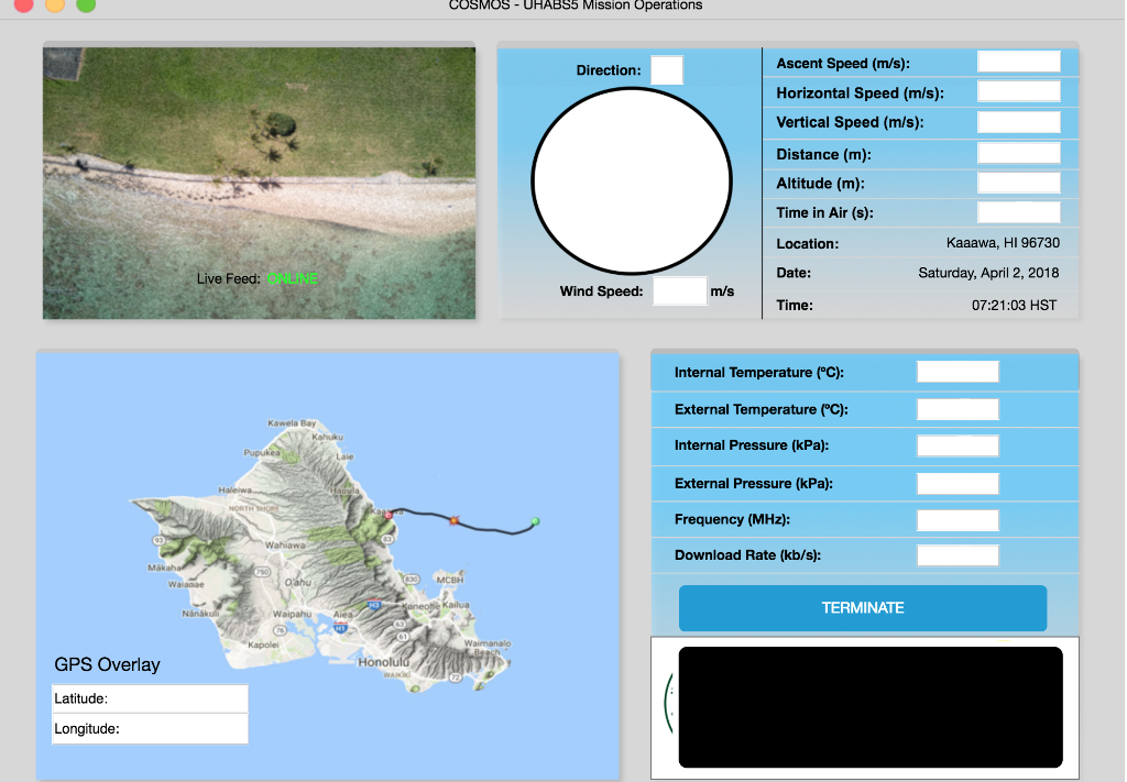 All the boxes will be seperate pictures. I just need to adjust it to where I need it located on the interface, and I need to know how to update the values of the sensors for each sensor box from the individual sensor txt data. The data will be contiously printed onto the txt file. We will need to print the newest value for each sensor on to the GUI. Until we close the GUI window, and our balloon satailte project has sucessfully landed.
COSMOS-UHABS5 Mission Operations Ascent Speed (m/s): Direction Horizontal Speed (m/s): Vertical Speed (m/s): Distance (m) Altitude (m): Time in Air (s): Location Date: Time: Kaaawa, HI 96730 Saturday, April 2, 2018 07:21:03 HST Feed: ONLINE Wind Speed: m/s Internal Temperature (C) External Temperature (C): Internal Pressure (kPa): External Pressure (kPa): Frequency (MHz) Download Rate (kb/s) Kawela Bay Mak MCBH TERMINATE Nink Kapole Waimanalo GPS Overlay Latitude Longitude COSMOS-UHABS5 Mission Operations Ascent Speed (m/s): Direction Horizontal Speed (m/s): Vertical Speed (m/s): Distance (m) Altitude (m): Time in Air (s): Location Date: Time: Kaaawa, HI 96730 Saturday, April 2, 2018 07:21:03 HST Feed: ONLINE Wind Speed: m/s Internal Temperature (C) External Temperature (C): Internal Pressure (kPa): External Pressure (kPa): Frequency (MHz) Download Rate (kb/s) Kawela Bay Mak MCBH TERMINATE Nink Kapole Waimanalo GPS Overlay Latitude Longitude
Step by Step Solution
There are 3 Steps involved in it

Get step-by-step solutions from verified subject matter experts