

Question: I. Using and calculating by Cartesian Coordinates ( lengths , angles, directions, polygonial & true km ' s ) 1 . 1 . Coordinates
I. Using and calculating by Cartesian Coordinates lengths angles, directions, polygonial & true kms
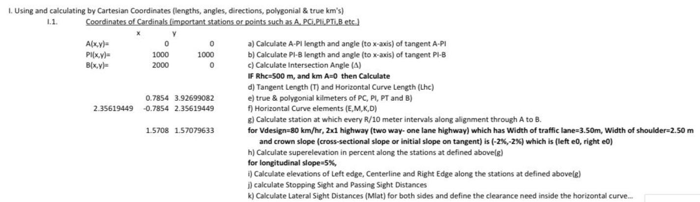
Coordinates of Cardinals important stations or points such as A PClPli,PTi, B etc.
IF Rhc m and km A then Calculate
d Tangent Length T and Horizontal Curve Length Lhc
e true & polygonial kilmeters of PC PI PT and B
f Horizontal Curve elements EMKD
g Calculate station at which every R meter intervals along alignment through A to B
for Vdesign kmhrx highway two way one lane highway which has Width of traffic lanem Width of shoulder m and crown slope crosssectional slope or initial slope on tangent is which is left e right e
h Calculate superelevation in percent along the stations at defined aboveg
for longitudinal slope
i Calculate elevations of Left edge, Centerline and Right Edge along the stations at defined aboveg
j calculate Stopping Sight and Passing Sight Distances
k Calculate Lateral Sight Distances Mlat for both sides and define the clearance need inside the horizontal curve...
Step by Step Solution
There are 3 Steps involved in it
1 Expert Approved Answer
Step: 1 Unlock

Question Has Been Solved by an Expert!
Get step-by-step solutions from verified subject matter experts
Step: 2 Unlock
Step: 3 Unlock