

Question: Name: Where Is the Nasty Stuff Going? A Using a pencil, make a topographic contour map of the water table at a contour interval
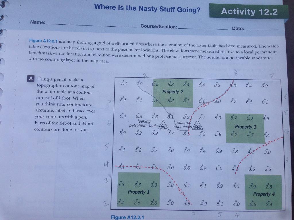
Name: Where Is the Nasty Stuff Going? A Using a pencil, make a topographic contour map of the water table at a contour interval of 1 foot. When you think your contours are accurate, label and trace over your contours with a pen. Parts of the 4-foot and 8-foot contours are done for you. Figure A12.2.1 is a map showing a grid of well-located sites where the elevation of the water table has been measured. The water- table elevations are listed (in ft.) next to the piezometer locations. The elevations were measured relative to a local permanent benchmark whose location and elevation were determined by a professional surveyor. The aquifer is a permeable sandstone with no confining layer in the map area. 6 5 7.4 6.8 6.4 5.9 5.1 Course/Section: -4.1-- 3.3 19 8 7.1 79 6.8 7.3 leaking petroleum tanks, 6.2 6.9 8.2 3.3 3.3 Property 1 8.3 8.4 8.4 Property 2 8.2 8.3 5.2 5.7 7.0 Figure A12.2.1 7.7 8.2 industrial chemicals/ 8. k 2.5 2.6 3.0 7.9 5.0 6.6 8.2 8.0 7.1 Activity 12.2 7.2 8.3 5.9 Date: 6.9 6.0 1.0 7.4 6.9 7.2 7.4 5.9 4.8 4.9 5.1 5.7 5.3 4.9 Property 3 5.8 5.2 4.7 5.1 6.1 5.9 4.0 4.1 3.6 6.8 4.0 4 6.3 2.9 4.4 3.8 3.3 2.8 Property 4 2.5 2.4 4
Step by Step Solution
3.41 Rating (151 Votes )
There are 3 Steps involved in it
70 60 50 40 30 74 68 64 59 33 80 79 82 83 84 84 83 80 Property ... View full answer

Get step-by-step solutions from verified subject matter experts