

Question: Solve using Excel The following network shows the major roads that would be part of the hurricane evacuation routes for Charleston, South Carolina: The destination
Solve using Excel
The following network shows the major roads that would be part of the hurricane evacuation
routes for Charleston, South Carolina:
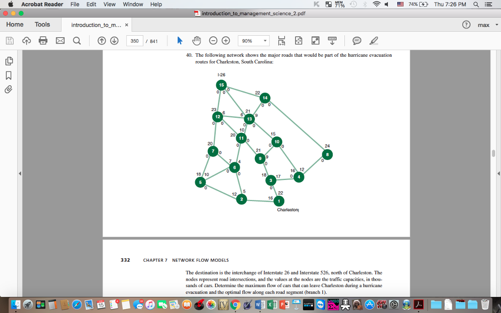
The destination is the interchange of Interstate 26 and Interstate 526, north of Charleston. The
nodes represent road intersections, and the values at the nodes are the traffic capacities, in thousands
of cars. Determine the maximum flow of cars that can leave Charleston during a hurricane
evacuation and the optimal flow along each road segment (branch 1). Solve in Excel
Acrobat Reader File Edit View Window Help E 74% Thu 7:26 PM 2 introduction to management science 2.pdf Home Tools introduction to m x 3500 84 9096 40. The following network shows the major roads that would be part of the hurricane evacuation routes for Charleston. South Carolina: 26 0 0 12 10 24 18 17 0 12 Charleston 332 CHAPTER 7 NETWORK FLOW MODELS The destination is the interchange of Interstate 26 and Interstate 526. north of Charleston. The nodes represent road intersections, and the values at the nodes are the traffic capacities, in thou- sands of cars. Determine the maximum flow of cars that can leave Charleston during a hurricane evacuation and the optimal flow along each road segment (branch 1)
Step by Step Solution
There are 3 Steps involved in it
StepbyStep Calculation for Maximum Flow Using the Network Flow Method We will calculate the maximum ... View full answer

Get step-by-step solutions from verified subject matter experts