

Question: The questions in this exercise are based on this contour line map with elevations shown in feet. North is to the top of the
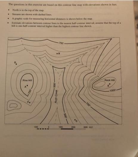
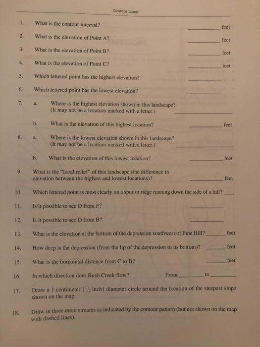
The questions in this exercise are based on this contour line map with elevations shown in feet. North is to the top of the map . Streams are shown with dashed lines A graphic scale for measuring horizontal distances is shown below the map Estimate elevations between contour lines to the nearest half-contour interval; assume that the top of a hill is one-half-contour interval higher than the highest contour line shown. Pine Hill TOOG COG Rush Creek -750 1000 100% 2000 -750 3000 FEET Rock Hill -1000- 1. 2. 3. 4. 5. 6. 7. 8. 9. 10. 11. 12. 13. 14. 15. 16. 18. 17. What is the contour interval? What is the elevation of Point A? What is the elevation of Point B? What is the elevation of Point C? Which lettered point has the highest elevation? Which lettered point has the lowest elevation? a. b. a Contour Lines b. Where is the highest elevation shown in this landscape? (It may not be a location marked with a letter.) What is the elevation of this highest location? Where is the lowest elevation shown in this landscape? (It may not be a location marked with a letter.) What is the elevation of this lowest location? From feet to feet feet feet feet What is the "local relief" of this landscape (the difference in elevation between the highest and lowest locations)? Which lettered point is most clearly on a spur or ridge running down the side of a hill? Is it possible to see D from F? Is it possible to see D from B? What is the elevation at the bottom of the depression southwest of Pine Hill? How deep is the depression (from the lip of the depression to its bottom)? What is the horizontal distance from C to B? In which direction does Rush Creek flow? Draw a 1 centimeter (/, inch) diameter circle around the location of the steepest slope shown on the map. feet feet feet feet feet Draw in three more streams as indicated by the contour pattern (but not shown on the map with dashed lines).
Step by Step Solution
3.41 Rating (160 Votes )
There are 3 Steps involved in it
Our experts were un... View full answer

Get step-by-step solutions from verified subject matter experts